
Rinteln is a small town in Lower Saxony, Germany. It is located on the banks of the Weser river above the Porta Westfalica. The town of Rinteln is in the broad valley between the hills of the Weserbergland and the North Lippe Bergland. In relation to some well known places, it is 60 kilometers west of Hanover, and just 20 kilometers from Hamelin of Pied Piper fame. Its population is about 28,500.

Weener is a town in the district of Leer, in Lower Saxony, Germany. It is situated near the border with the Netherlands, on the river Ems. The towns population is at 15,654, making it the largest town of the region Rheiderland. It has a railway and autobahn connection to Groningen, Netherlands, Emden and Bremen.

Walkenried is a municipality in the district of Göttingen, in Lower Saxony, Germany. It is situated in the southern Harz, approx. 15 km south of Braunlage, and 15 km northwest of Nordhausen.

Wiefelstede is a municipality in the Ammerland district, in Lower Saxony, Germany. It is situated approximately 15 km northwest of Oldenburg.
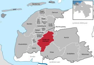
Südbrookmerland is a municipality in the district of Aurich, in Lower Saxony, Germany. It is situated approximately 7 km west of Aurich. Its seat is in the village Victorbur.

Eschede is a municipality in the district of Celle, in Lower Saxony, Germany. Situated approximately 15 km northeast of Celle, Eschede lies at the border of the Südheide Nature Park, a protected area of large forests and heaths. Today around 20 small villages are part of the "Gemeinde Eschede".
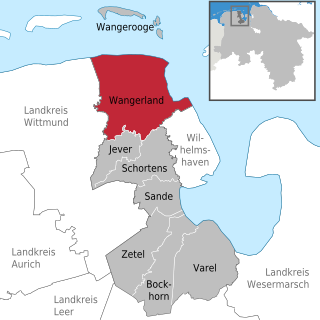
Wangerland is a municipality in the district of Friesland, Lower Saxony, Germany. It is situated on the North Sea coast, approximately 20 km northwest of Wilhelmshaven, and 10 km north of Jever. Its seat is in the village Hohenkirchen.

Sassenburg is a municipality in the district of Gifhorn, Lower Saxony, Germany. It is situated approximately 7 km northeast of Gifhorn, and 15 km northwest of Wolfsburg. Sassenburg includes the villages of Dannenbüttel, Grußendorf, Neudorf-Platendorf, Stüde, Triangel and Westerbeck. The seat of the municipality is in the village Westerbeck.
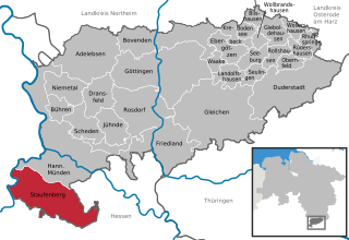
Staufenberg is the southernmost municipality of the district of Göttingen, and of Lower Saxony, Germany. It is situated east of the river Fulda, approx. 6 km south of Hannoversch Münden, and 12 km northeast of Kassel. Its seat is in the village Landwehrhagen.

Seevetal is a municipality in the district of Harburg, in Lower Saxony, Germany. It is situated approximately 20 km south of Hamburg, and 15 km west of Winsen (Luhe). Its seat is in the village Hittfeld. It is named after the river Seeve.

Lamspringe is a village and a municipality in the district of Hildesheim, in Lower Saxony, Germany. It is situated approximately 20 km south of Hildesheim. Since 1 November 2016, the former municipalities Harbarnsen, Neuhof, Sehlem and Woltershausen are part of the municipality Lamspringe.
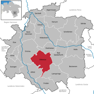
Sibbesse is a village and a municipality in the district of Hildesheim, in Lower Saxony, Germany. It is situated approximately 10 km south of Hildesheim. Since 1 November 2016, the former municipalities Adenstedt, Almstedt, Eberholzen and Westfeld are part of the municipality Sibbesse.
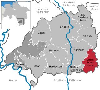
Katlenburg-Lindau is a municipality in the Landkreis (district) of Northeim in Lower Saxony, Germany. It is situated approximately 10 km southeast of Northeim, and 20 km northeast of Göttingen. Katlenburg-Lindau was formed on 1 March 1974 from the formerly independent communities of Katlenburg-Duhm, Gillersheim, Berka, Elvershausen, Wachenhausen, Suterode and Lindau. With the exception of Lindau, which had belonged Landkreis Duderstadt, these communities were part of Landkreis Northeim. The Max Planck Institute for Solar System Research of the Max Planck Society was located in Lindau from 1946 to 2014, when it was moved to Göttingen. Until June 2004 the MPI was known as "Max-Planck-Institut für Aeronomie".

Belm is a municipality in the district of Osnabrück, in Lower Saxony, Germany. It is located in the Wiehengebirge, approximately 7 km northeast of Osnabrück, and is therefore part of the city-agglomeration of Osnabrück. It is seated in the middle of the TERRA.vita Nature Park. Two little right tributaries of the river Hase flow through it.
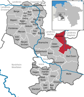
Bohmte is a municipality in the district of Osnabrück, in Lower Saxony, Germany. It is situated on the river Hunte, approx. 20 km northeast of Osnabrück. The foundation of today's Bohmte is a result of the regional reorganization of 1972, when the towns of Bohmte, Herringhausen-Stirpe-Oelingen and Hunteburg were consolidated.

Wallenhorst is a municipality in the district of Osnabrück, in Lower Saxony, Germany. It is situated in the Wiehengebirge, approx. 10 km north of Osnabrück.
Bad Lauterberg is a town in the district of Göttingen, in Lower Saxony, Germany. It is situated in the southern Harz, approx. 15 km southwest of Braunlage, and 20 km southeast of Osterode am Harz.

Bad Grund (Harz) is a town in the district of Göttingen, in Lower Saxony, Germany. It is situated in the western Harz, approx. 7 km west of Clausthal-Zellerfeld, and 10 km north of Osterode am Harz.

Auetal is a municipality in the district of Schaumburg, in Lower Saxony, Germany. It is situated approximately 10 km south of Stadthagen, and 22 km east of Minden. Its seat is in the village Rehren.

Apen is a municipality in the district of Ammerland, in Lower Saxony, Germany.


