The HVDC Haenam–Cheju is a 101 kilometer long HVDC submarine cable connection between the Korean Peninsula and the island of Jeju in South Korea, which went into service in 1996. The connection is bipolar, consisting of two 180kV cables with a maximum transmission power of 300 megawatts.
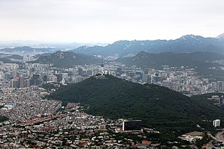
Namsan, officially Namsan Mountain, is a 270-meter (890 ft)-high peak in Jung-gu, Seoul, South Korea. It was also known as Mongmyeoksan, or 목멱산 / 木覓山 in the past. It offers some hiking, picnic areas and views of downtown Seoul's skyline. The N Seoul Tower is located on top of Mt. Namsan.
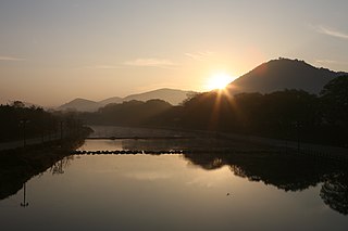
The Yeongsangang is a river in south-western South Korea. It has a length of 129.50 km, and covers an area of 3,467.83 km2. It runs through Damyang, Naju, Gwangju and other regions and eventually flows into the Yellow Sea at Yeongam through the estuary bank.
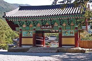
Daeheungsa (Korean: 대흥사), sometimes called Daedunsa, is a main temple of the Jogye Order of Korean Buddhism. Daeheungsa is located on the slopes of Duryunsan in Samsan township, Haenam County, South Jeolla Province, South Korea.
Dalmasan, Mt. Dalma, is part of the Taebaek mountain range and lies in Haenam county, South Jeolla province, South Korea. Its elevation is 489 meters, and its peak offers views of the "Land's Edge," (땅끝) the southernmost point on the Korean peninsula, 땅끝마을, and outlying islands such as Wando. Also in the vicinity are Mihwangsa and a number of hermitages affiliated with it.

Gamaksan, also known as Kamak Mountain or Hill 675 (675고지) during the Korean War, is a mountain in Gyeonggi Province, South Korea. Its sits between the cities of Paju, Yangju and Yeoncheon County. Gamaksan has an elevation of 675 m (2,215 ft).
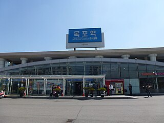
Mokpo station is a station on the Honam Line in Mokpo, South Jeolla Province. It is the westernmost railway station in South Korea. This station is the last stop on the Honam Line. Being located in the southwestern part of the Korean peninsula, it is used by customers who visit Jeju Island, Heuksan Island, and Hong Island in connection with KTX.

The Second Battle of Seoul resulted in United Nations forces recapturing Seoul from the North Koreans in late September 1950.
Deoksungsan is a mountain of Chungcheongnam-do, western South Korea. It has an elevation of 495 metres.
Mansusan is a mountain of Chungcheongnam-do, western South Korea. It has an elevation of 575 metres.
Museongsan is a mountain of Chungcheongnam-do, western South Korea. It has an elevation of 614 metres.
Oseosan is a mountain of Chungcheongnam-do, western South Korea. It has an elevation of 791 metres.
Naebyeonsan is a mountain of Jeollabuk-do, western South Korea. It has an elevation of 459 metres.
Seonunsan is a mountain of Jeollabuk-do, western South Korea, with an elevation of 336 metres. It is a popular destination for hiking, with a variety of trails. Some leading to a giant 13m carving of Buddha on a cliff, which dates back to the Goryeo dynasty. It is also one of the premier sport climbing destinations in South Korea, having perhaps the highest concentration of difficult routes in the country.
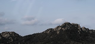
Duryunsan is a mountain of Jeollanam-do, western South Korea. It has an elevation of 700 metres.
Jeamsan is a mountain of Jeollanam-do, southwestern South Korea. It has an elevation of 807 metres.
Suinsan is a mountain in the South Jeolla Province of southwestern South Korea. It has an elevation of 561 metres.
Sudosan is a mountain of Gyeongsangbuk-do, eastern South Korea. It has an elevation of 1,317 metres.

Yunggeolleung is a burial ground from the Joseon dynasty, located within an oak-forested park in Hwaseong, South Korea. Yungneung is the tomb of Crown Prince Sado and Lady Hyegyeong, while Geolleung houses King Jeongjo and Queen Hyoui. They are an UNESCO World Heritage Site.
Yudalsan is a mountain located in Mokpo, South Jeolla Province, South Korea. It is 228 m (748 ft) tall. The mountain is sometimes called the Gaegol of the Honam Region, in reference to a nickname for Geumgangsan.
