Westleigh is a suburb in the Upper North Shore region of Sydney in the state of New South Wales, Australia, 22 kilometres north-west of the Sydney central business district in the local government area of Hornsby Shire.
Eucalyptus camaldulensis, commonly known as the river red gum, is a species of flowering plant in the family Myrtaceae, and is endemic to Australia. It is a tree with smooth white or cream-coloured bark, lance-shaped or curved adult leaves, flower buds in groups of seven or nine, white flowers and hemispherical fruit with the valves extending beyond the rim. A familiar and iconic tree, it is seen along many watercourses across inland Australia, providing shade in the extreme temperatures of central Australia.
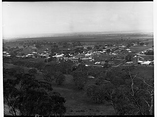
Melrose is the oldest town in the Flinders Ranges, South Australia. The town was once named "Mount Remarkable".

King William Street is the part of a major arterial road that traverses the CBD and centre of Adelaide, continuing as King William Road to the north of North Terrace and south of Greenhill Road; between South Terrace and Greenhill Road it is called Peacock Road. At approximately 40 metres (130 ft) wide, King William Street is the widest main street of all the Australian State capital cities. Named after King William IV in 1837, it is historically considered one of Adelaide's high streets, for its focal point of businesses, shops and other prominent establishments. The Glenelg tram line runs along the middle of the street through the city centre.
The City of Burnside is a local government area in the South Australian city of Adelaide stretching from the Adelaide Parklands into the Adelaide foothills with an area of 2,753 hectares. It was founded in August 1856 as the District Council of Burnside, the name of a property of an early settler, and was classed as a city in 1943. The LGA is bounded by Adelaide, Adelaide Hills Council, Campbelltown, Mitcham, Norwood Payneham and St Peters and Unley.

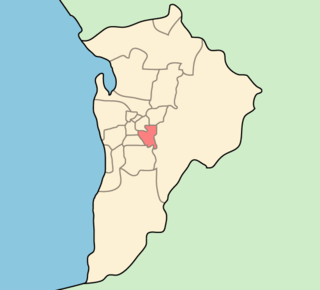
The City of Unley is a local government area in the Adelaide metropolitan region. It is located directly south of the Adelaide city centre.

Black Forest is an inner southern suburb of Adelaide, South Australia. It is located in the City of Unley, bounded by the Glenelg tram line (north-west), the Seaford railway line (south-east), South Road (west) and East Avenue (east).
Fullarton is an inner southern suburb of Adelaide, South Australia in the City of Unley.

Totness Recreation Park is a protected area in the Australian state of South Australia located within the localities of Mount Barker and Totness in the central Mount Lofty Ranges. Covering 41 hectares of land, the park is divided by the South Eastern Freeway and features a large dam. It was declared as a reserve in 1970 and re-designated as a recreation park in 1972. The park has no visitor facilities except for access tracks. It is the only park in the district, managed by the Department of Environment and Water, that is solely designated for recreation.

The Northern Tablelands, also known as the New England Tableland, is a plateau and a region of the Great Dividing Range in northern New South Wales, Australia. It includes the New England Range, the narrow highlands area of the New England region, stretching from the Moonbi Range in the south to the Queensland border in the north. The region corresponds generally to the Bureau of Meteorology forecast area for the Northern Tablelands which in this case includes Inverell although it is significantly lower in elevation.

Gumeracha is a town in the Adelaide Hills, South Australia, located on the Adelaide-Mannum Road. It is located in the Adelaide Hills Council local government area on the south bank of the upper River Torrens. At the 2006 census, Gumeracha had a population of 731.
Haslam is a town and a locality in the Australian state of South Australia located on the Eyre Peninsula on the coastline of Streaky Bay about 487 kilometres (303 mi) north-west of the state capital of Adelaide and about 32 kilometres (20 mi) north of the municipal seat of Streaky Bay.

Cobbler Creek Recreation Park is a 266-hectare (657-acre) protected area located in South Australia about 19 kilometres (12 mi) north of the Adelaide city centre in the suburb of Salisbury East. Originally part of the lands of the Kaurna aboriginal people, it was farmed from European settlement of South Australia until the declaration of the park in 1989.

Anstey Hill Recreation Park is a 362-hectare (890-acre) protected area established in 1989 and located approximately 19 kilometres (12 mi) northeast of Adelaide, South Australia. The park is a significant reserve of bushland in the foothills of the Mount Lofty Ranges and is home to rare or vulnerable native plants and animals, and problematic invasive species. It is managed by the City of Tea Tree Gully, the Department of Environment, Water and Natural Resources and a volunteer group—The Friends of Anstey Hill. The park is designed for recreational walking and has no visitor facilities. It is managed in association with the regional planning initiative known as of Yurrebilla, the Greater Mount Lofty Parklands.
W. H. Burford and Sons was a soap and candle-making business founded in Adelaide in 1840 by William Henville Burford (1807–1895), an English butcher who arrived in the new colony in 1838. It was one of the earliest soapmakers in Australia, and up to the 1960s when it closed, the oldest. In 1878 he took his two sons Benjamin and William into partnership as W. H. Burford & Sons. Its expansion, accompanied by a number of takeovers, made it the dominant soap manufacturer in South Australia and Western Australia. Its founders were noted public figures in the young city of Adelaide.

Gum Lagoon Conservation Park is an 8765 ha protected area about 40 km south-west of Keith in the Limestone Coast region of South Australia. It lies about 20 km inland from the southern end of the Coorong. It contains an isolated block of mallee woodland important for malleefowl conservation.
William Haslam was a small businessman and politician in the Colony of South Australia.

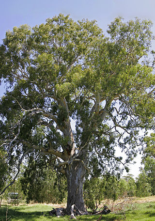
The Cazneaux Tree, also known as Cazneaux's Tree, is a Eucalyptus camaldulensis or river red gum that was made famous by the photographer Harold Cazneaux. It is in the Australian state of South Australia in the locality of Flinders Ranges near Wilpena Pound. The tree is located within the boundaries of the Ikara-Flinders Ranges National Park on the west side of the Flinders Ranges Way about 3 kilometres (1.9 mi) north-east of the Wilpena Pound Resort.

The Blue Gum Forest is a forest located in Blue Mountains National Park within the Grose Valley of the Blue Mountains in New South Wales west of Sydney, southeastern Australia. It is one of the best-known bushwalking sites in Australia. The forest is located within the UNESCO World Heritage Site known as the Greater Blue Mountains Area. The forest survived through the efforts of early Australian conservationists.
Tarella Quin or Quinn (1877–1934), was an Australian children's author and novelist. She was also known as Mrs T. S. Daskein.


