The Dandenong Ranges are a set of low mountain ranges in Victoria, Australia, approximately 35 km (22 mi) east of the state capital Melbourne. A minor branch of the Great Dividing Range, the Dandenongs consist mostly of rolling hills, rising to 633 m (2,077 ft) at Mount Dandenong, as well as steeply weathered valleys and gullies covered in thick temperate rainforest, predominantly of tall mountain ash trees and dense ferny undergrowth. The namesake Dandenong Creek and most of its left-bank tributaries originate from headwaters in these mountain ranges. Two of Melbourne's most important storage reservoirs, the Cardinia and Silvan Reservoir, are also located within the Dandenongs.

Hunter Mountain is in the towns of Hunter and Lexington, just south of the village of Hunter, in Greene County, New York, United States. At approximately 4,040 feet (1,231 m) in elevation, it is the highest peak in the county and the second-highest peak in the Catskill Mountains.

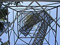
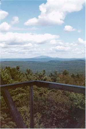
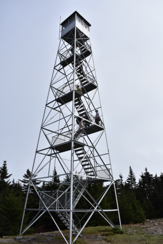
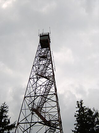
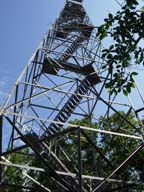
A fire lookout tower, fire tower, or lookout tower is a tower that provides housing and protection for a person known as a "fire lookout", whose duty it is to search for wildfires in the wilderness. It is a small building, usually on the summit of a mountain or other high vantage point to maximize viewing distance and range, known as view shed. From this vantage point the fire lookout can see smoke that may develop, determine the location by using a device known as an Osborne Fire Finder, and call for wildfire suppression crews. Lookouts also report weather changes and plot the location of lightning strikes during storms. The location of the strike is monitored for a period of days afterwards, in case of ignition.
Mount Grace, 1,617 feet (493 m), is a prominent monadnock located in north central Massachusetts in the town of Warwick, approximately two miles south of the New Hampshire border. The mountain is rugged and largely wooded, but a firetower on the summit provides expansive views of the surrounding rural countryside. Little Mount Grace, 1,226 feet (374 m), is the southern summit of the mountain. Mount Grace supports a predominantly northern hardwood forest as well as stands of red spruce near its summit.
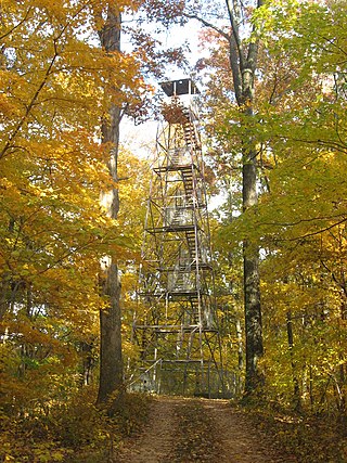
The Hunter Mountain Fire Tower is located on the summit of the eponymous mountain, second highest of the Catskill Mountains in the U.S. state of New York. It was the first of 23 fire lookout towers built by the state in the region, and the next-to-last of the five still standing to be abandoned.

Massaemett Mountain is a mountain in Shelburne, Franklin County, Massachusetts, USA. It is named for a chief of the Pocumtuck tribe, a confederacy of Native Americans who inhabited the region. Part of the Berkshire Mountains, Massaemett lies just east of the village of Shelburne Falls, 7 miles (11 km) west of the county seat of Greenfield, Massachusetts, and 87 miles (140 km) west of Boston. The summit features a historic stone fire tower constructed in 1909. The top cab is not open to the public, however the stairway is kept open and offers views from multiple windows facing the four directions of the compass. From the tower, views include the Berkshires and Taconic Mountains to the west, the Green Mountains of Vermont to the north, Mount Wachusett to the east, and the Holyoke Range to the south.

The Watchman Lookout Station No. 168 is one of two fire lookout towers in Crater Lake National Park in southern Oregon. For many years, National Park Service personnel used the lookout to watch for wildfires during the summer months. It is also a common hiking destination because of its views of Crater Lake and the surrounding area. The building is unusual because it serves the dual purpose of fire lookout and museum. The Watchman Lookout Station is listed on the National Register of Historic Places.
Olson Observation Tower is one of the few remaining fire towers in Monongahela National Forest. Olson is located at the southern end of Backbone Mountain northeast of Parsons in Tucker County, West Virginia.

The Red Hill Fire Observation Station consists of a fire lookout tower, cabin and pit privy located on the summit of Red Hill, a 2,990-foot (910 m) Catskill Mountain peak in Denning, New York, United States. It is the southernmost fire tower in the Catskill Park.

The Balsam Lake Mountain Fire Observation Station is located at the summit of the mountain of that name in the Town of Hardenburgh, New York, United States. It comprises a steel frame fire lookout tower, the observer's cabin and privy and the jeep road to the complex.

The Loon Lake Mountain Fire Observation Station is a historic fire observation station located on the western end of the Loon Lake Mountains west of Loon Lake in Franklin County, New York in the Debar Mountain Wild Forest. The station and contributing resources include a 35-foot-tall (10.7 m), steel-frame lookout tower erected in 1917; it replaced a wooden fire tower that was constructed in 1912. The tower has been unused since 1971, and the stairs have been removed to keep people from climbing it.

The Unity Ranger Station is a United States Forest Service compound consisting of five buildings and a lookout tower in the Wallowa-Whitman National Forest of northeastern Oregon. It was previously the administrative headquarters for the Unity Ranger District. It is located in the small unincorporated community of Unity, Oregon. The historic structures were built in the rustic style by the Civilian Conservation Corps between 1936 and 1938. Today, the ranger station is only used during the summer months to house Forest Service fire crews. The ranger station is listed on the National Register of Historic Places.
Union Lookout is a lookout tower located within Trail of Tears State Forest in Union County, Illinois, United States. The Civilian Conservation Corps built the tower circa 1934 as part of a network of fire lookout towers in Shawnee National Forest; the fire towers were one of many CCC conservation projects in the forest, which also included planting trees, constructing bridges and trails, and preventing erosion. The tower was used through the 1960s, by which time airplanes had largely replaced towers as a means of detecting fires; it is now the only remaining lookout tower in the forest. On February 5, 2003, Union Lookout was added to the National Register of Historic Places.
The Udell Lookout Tower is a fire lookout tower located on Forest Road 5207 in the Manistee section of the Huron-Manistee National Forests, near Wellston, Michigan. It was placed on the National Register of Historic Places in 1996.

Rock Rift Fire Observation Tower, also known as the Rock Rift Fire Tower, is a historic fire observation station located in the Town of Tompkins, Delaware County, New York. The tower stands at the summit of Tower Mountain at an elevation of 2,376 ft (724 m) and rises above the Cannonsville Reservoir, part of New York City’s extensive water supply system. It was built in 1934 and listed on the National Register of Historic Places # 100003231 in 2018. The Rock Rift Fire Tower is also listed on the National Historic Lookout Register of the Forest Fire Lookout Association. Its listing numbers are US 1183, NY 41. The tower was transferred to the Town of Tompkins from New York State Department of Environmental Conservation in 2017. The land that the tower rests on is owned by New York City as part of their West of Hudson Watershed. The tower was decommissioned from active use in 1989.

The Chews Ridge Lookout is located at the northern end of the Santa Lucia Range of the Los Padres National Forest, about 50 miles (80 km) southeast of Monterey, California and approximately 30 miles (48 km) west of Highway 101. The current tower was built in 1929 and staffed until around 1990. A volunteer organization began recruiting individuals to staff the tower in 2019. The ridge and tower were named for homesteaders Constantine and Nellie Chew, who patented 315 acres (127 ha) on the ridge in the late 19th century.

The Ojibway Fire Tower is a fire tower located at the junction of Greenstone Ridge and Mt. Ojibway Trails in Isle Royale National Park. The tower was listed on the National Register of Historic Places in 2021.
Tower Mountain is a mountain located in the Catskill Mountains of New York state, east-northeast of Deposit in Delaware County. Speedwell Mountain is located west-southwest of Tower Mountain, Walton Mountain is located north-northeast of it, and Crane Hill is located northeast of Tower Mountain. In 1934, the Civilian Conservation Corps built what was known as the Rock Rift Fire Observation Tower on the mountain. The tower ceased fire lookout operations at the end of the 1988 season and was officially closed in early 1989. Currently, the tower is not safe to climb. The first set of steps has been removed to prevent injury. Restoration of the tower is planned by the Town of Tompkins.

The Moore Lookout Tower is a historic fire lookout tower located on Scott County Road 503 in Forest, Scott County, Mississippi. Built in 1940 by the Civilian Conservation Corps (CCC), the tower is a rare example of its type and has been listed on the National Register of Historic Places.