Queenstown is a resort town in Otago in the south-west of New Zealand's South Island. It has an urban population of 29,000.

The Kawarau River is a river in the South Island of New Zealand. It drains Lake Wakatipu in northwestern Otago via the lake's Frankton Arm. The river flows generally eastwards for about 60 kilometres (37 mi) and passes through the steep Kawarau Gorge until it joins Lake Dunstan near Cromwell. Before the construction of the Clyde High Dam, the Kawarau joined the Clutha River / Mata-Au in a spectacular confluence at Cromwell. The Shotover River enters the Kawarau from the north; the Nevis River enters it from the south. With many rapids and strong currents, the river can be dangerous and has claimed many lives. It is popular for bungy jumping and kayaking.

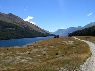
Lake Wakatipu is an inland lake in the South Island of New Zealand. It is in the southwest corner of the Otago region, near its boundary with Southland. Lake Wakatipu comes from the original Māori name Whakatipu wai-māori.
Mavora Lakes is a protected area in the South Island of New Zealand consisting of two lakes: North Mavora and South Mavora. The lakes are drained by the Mararoa River. The area is managed by the Department of Conservation, and is part of Te Wahipounamu, a World Heritage Area.

The Shotover River is located in the Otago region of the South Island of New Zealand. The name correctly suggests that this 75-kilometre (47 mi) long river is fast flowing, with numerous rapids. The river flows generally south from the Southern Alps on its journey running through the Skippers Canyon, draining the area between the Richardson Mountains and the Harris Mountains, before flowing into the Kawarau River east of Queenstown.

Coronet Peak is a commercial skifield in Queenstown, New Zealand located seven kilometres west of Arrowtown, on the southern slopes of the 1,649-metre peak which shares its name. A popular ski resort in the Southern Hemisphere, Coronet Peak offers a long snow season, well received skiing and snowboarding terrain and lift systems.
The Crown Range is a mountain range that lies to the east of the Wakatipu Basin in Otago, New Zealand. It is noted for two features, the Cardrona Alpine Resort, on the slopes of the 1900 metre Mount Cardrona, and a highway, known as the Crown Range Road, which winds steeply between Arrow Junction, just south of Arrowtown, and Wānaka to the north.

TSS Earnslaw is a 1912 Edwardian twin screw steamer based at Lake Wakatipu in New Zealand. She is one of the oldest tourist attractions in Central Otago, and the only remaining commercial passenger-carrying coal-fired steamship in the southern hemisphere.
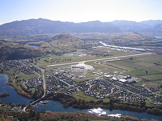
Frankton is a suburb of the town of Queenstown in the South Island of New Zealand, it was formerly a separate settlement.
Invincible Snowfields is a private ski resort near Glenorchy in the South Island of New Zealand.
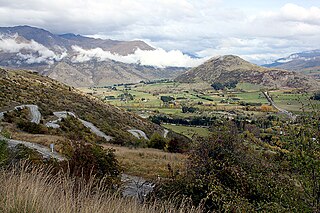
The Wakatipu Basin is a plain surrounded by mountains in Queenstown Lakes District, in the southern South Island of New Zealand.

Eichardt‘s Private Hotel is located on the corner of Marine Parade and Ballarat Street, Queenstown, New Zealand, on the shores of Lake Wakatipu. Eichardt’s is a significant local landmark, and is listed as a Category Two historic place by the Historic Places Trust.
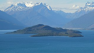
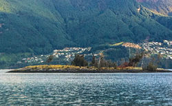
Pigeon Island / Wāwāhi Waka is an island in the northern reaches of New Zealand's Lake Wakatipu, near the township of Glenorchy. It is 170 hectares in size and is the largest island in the lake. In 1884, during Queen Victoria's reign, it was gifted by the Crown as a reserve to the people of Queenstown district for their use and enjoyment.
Cecil Peak is a mountain in the Wakatipu Basin, New Zealand and reaches a height of 1,978 metres. It is on the south side of Lake Wakatipu south-southwest of Queenstown, and is highly prominent from around this area.
Queenstown Police Station is the largest police station in the Otago Lakes Central Area which is one of three policing areas in the Southern District of the New Zealand Police. The Otago Lakes Central Area headquarters has returned to Queenstown Police Station after a period at Alexandra Police Station. The area of responsibility covered by the Queenstown Police extends from Kingston in the south, to the Crown Range summit in the north, and from Glenorchy and its environs in the west, to the Roaring Meg power station in the Kawarau Gorge in the east.

Queenstown Hill, also known by its Māori name of Te Tapu-nui, is a small 907 metres (2,976 ft) mountain near Queenstown, New Zealand in the South Island.

The Queenstown Trail is a cycle and walking trail funded as one of the projects of the New Zealand Cycle Trail (NZCT) system in Otago, New Zealand. It links the towns of Queenstown, Arrowtown, the suburb of Jack's Point and the area of Gibbston. It is at least 110 km in length but is not linear and instead follows the terrain often near rivers and lakes to link key places in a series of tracks that also access public land. In some places it also passes through private land such as working farms and users are encouraged to stay on the trail. The trail is a joint venture between the Government, Queenstown Lakes District Council and the Queenstown Trails Trust.

Kelvin Peninsula is a peninsula on the shore of Lake Wakatipu in New Zealand's Otago Region. The peninsula lies between the main body of Lake Wakatipu and the lake's Frankton Arm and its outlet, the Kawarau River. The centre of Queenstown lies on the opposite shore of the Frankton Arm. The peninsula was formerly called Kelvin Heights Peninsula. The name Kelvin Heights is still used for the Queenstown suburb which sits on the peninsula.
Queenstown-Lakes District Council is the territorial authority for the Queenstown-Lakes District of New Zealand.

Skyline Queenstown is a tourist attraction service in Queenstown, New Zealand. Skyline provides a gondola, a restaurant at the top station, and a luge back to the base station. It is owned by Skyline Enterprises.