
Derwentside was, from 1974 to 2009, a local government district in County Durham, England.
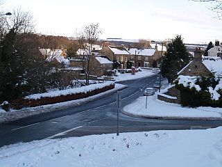
Burnopfield is a village in County Durham, in England. It is situated north of Stanley and Annfield Plain, close to the River Derwent and is 564 feet above sea level. There are around 4,553 inhabitants in Burnopfield. It is located 7 miles from Newcastle upon Tyne and 15 miles from Durham.

Dipton is a village located in County Durham, England. It is situated to the north-east of Consett, 3 miles south west of Burnopfield and a short distance to the north-west of Annfield Plain.

High Westwood is an English village in County Durham, a few miles to the north of Consett, near Ebchester and Hamsterley. It once had a colliery and coke works.
Ebchester is a village in County Durham, England. It is situated to the north of Consett and to the south east of Whittonstall and the hamlet of Newlands. The village sits at the intersection of the A694, which runs from Consett to Swalwell, and the B6309, which connects the A696 north of Belsay and runs through Whittonstall and Newlands, across the River Derwent, up Chare Bank then through Ebchester itself then past Medomsley into the A691 immediately south of the village of Leadgate.
Medomsley is a village in County Durham, England. It is about 2 miles (3 km) northeast of the centre of Consett, 1+1⁄2 miles (2 km) south of Hamsterley and 1 mile (2 km) southeast of Ebchester along the B6309. Leadgate lies a further mile to the south east.

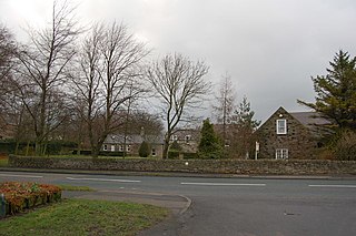
Low Westwood is a village in County Durham, England. It is situated immediately to the west of Hamsterley. Low Westwood is probably best known for Hamsterley Christ Church and Derwent care home.

Hamsterley is a village in County Durham, England. It is situated to the north of Consett and borders the hamlet of Low Westwood.
Cornsay Colliery is a village in County Durham, England. It is situated a few miles to the west of Durham, close to Cornsay, Quebec and Esh Winning.
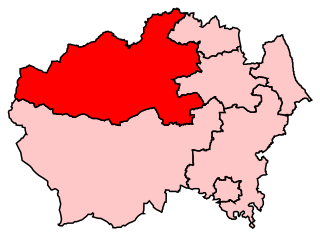
North West Durham was a constituency represented in the House of Commons of the UK Parliament.

Hylton Castle is a stone castle in the North Hylton area of Sunderland, Tyne and Wear, England. Originally built from wood by the Hilton family shortly after the Norman Conquest in 1066, it was later rebuilt in stone in the late 14th to early 15th century. The castle underwent major changes to its interior and exterior in the 18th century and it remained the principal seat of the Hylton family until the death of the last Baron in 1746. It was then Gothicised but neglected until 1812, when it was revitalised by a new owner. Standing empty again until the 1840s, it was briefly used as a school until it was purchased again in 1862. The site passed to a local coal company in the early 20th century and was taken over by the state in 1950.
Hilton is a village and civil parish in County Durham, about 9 miles (14 km) northwest of Darlington. Nearby places are Ingleton and Staindrop.

Stainmore is a remote geographic area in the Pennines on the border of Cumbria, County Durham and North Yorkshire. The name is used for a civil parish in the Eden District of Cumbria, England, including the villages of North Stainmore and South Stainmore. The parish had a population of 253 in the 2001 census, increasing to 264 at the Census 2011. Stainmore Forest stretches further east into County Durham, towards Bowes.

Scremerston is a village in Northumberland, England. The village lies on the North Sea coast just under 2.5 miles (4 km) south of Berwick-upon-Tweed and 4.3 miles (7 km) from the Anglo-Scottish border. It is adjacent to the A1, providing access to Newcastle upon Tyne to the south, and to Edinburgh to the north.

The Durham Coalfield is a coalfield in north-east England. It is continuous with the Northumberland Coalfield to its north. It extends from Bishop Auckland in the south to the boundary with the county of Northumberland along the River Tyne in the north, beyond which is the Northumberland Coalfield.
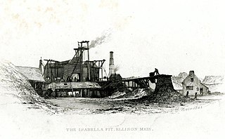
Sheriff Hill Colliery or Ellison Main Colliery was a coal mine at Gateshead Fell in County Durham, England. The colliery had two shafts and provided employment to the residents of Sheriff Hill, after it opened in 1793. There were many major accidents resulting in the deaths of workers at the colliery. There was a protracted strike at the colliery in 1834. The colliery closed in 1926.
Captain Sir Thomas Liddell, 1st Baronet (1578–1652) was an English politician, a member of the Liddell family which monopolized the local government of the North of England during the 16th and 17th centuries. He was one of the leading supporters of the Royalist cause in the English Civil War.
The palatine courts of Durham were a set of courts that exercised jurisdiction within the County Palatine of Durham. The bishop purchased the wapentake of Sadberge in 1189, and Sadberge's initially separate institutions were eventually merged with those of the County Palatine.
Farnacres is a locality in Tyne and Wear, in north-east England.

Croft Bridge is a road bridge over the River Tees, straddling the border between North Yorkshire and County Durham, in the north of England. The road over the bridge is now the A167, previously a second branch of the Great North Road, meeting the old road in Darlington. The bridge dates back to Medieval times, and is the setting for the awarding of a sword to the incoming Bishop of Durham.
