Easington was, from 1974 to 2009, a local government district in eastern County Durham, England. It contained the settlements of Easington, Seaham, Peterlee, Murton, Horden, Blackhall, Wingate and Castle Eden. It did not however include Easington Lane which is administered as part of the City of Sunderland.

Pittington is a village and civil parish in County Durham, in England. It is situated a few miles north-east of Durham. The population as taken at the 2011 census was 2,534.

Shadforth is a village in County Durham, England, a few miles east of Durham. The historic centre of the village is a conservation area. The population at the 2011 census was 2,118.

Wingate is a village in County Durham, England.

Haswell is a village in County Durham, in England. It is situated 6 miles (9.7 km) east of the city of Durham, 9 miles (14 km) south of the city of Sunderland and 3.1 miles (5.0 km) north-west of the town of Peterlee.

Haswell Moor is a small village in County Durham, England. It is situated between Haswell and Shotton Colliery.

Haswell Plough is a village in County Durham, England. It is situated between Durham and Peterlee, south of Haswell. Haswell Plough was first mentioned in the 12th century as being one of three parts of the village of Haswell. It is also the village where MEP of thirty years Stephen Hughes was brought up.

Healeyfield is a village and civil parish in County Durham, England. The population of the civil parish taken from the 2011 census was 1,544. It is situated to the south west of Consett.
Gilesgate is a suburb of Durham in County Durham, England. It had a population at the 2011 census of 8,074.

Hunwick is a semi-rural village in County Durham, England. There are actually two villages that are often referred to collectively as Hunwick, Hunwick and New Hunwick although it is generally accepted that the two villages are now as one. In the 2001 census Hunwick had a population of 952. This had grown to 1248 by the 2011 census.

Easington is a constituency created in 1950 represented in the House of Commons of the UK Parliament since 2010 by Grahame Morris of the Labour Party.
Croxdale and Hett is a civil parish in County Durham, England. It is situated approximately four miles south of Durham. The population of the civil parish as taken at the 2011 census was 866.

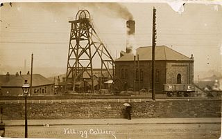
The Felling Colliery in Britain, suffered four disasters in the 19th century, in 1812, 1813, 1821 and 1847. By far the worst of the four was the 1812 disaster which claimed 92 lives on 25 May 1812. The loss of life in the 1812 disaster was one of the motivators for the development of miners' safety lamps such as the Geordie lamp and the Davy lamp.
High Spen is an old mining village in the Metropolitan Borough of Gateshead, historically part of County Durham. First recorded in 1379 as a small hamlet called ‘Spen’, the settlement grew in the latter half of the 19th and early 20th centuries with the growth of coal mining in the region. In a modern post-industrial North East England, High Spen functions as a commuter village in the Tyneside greenbelt with 1,935 people calling the village home
National Cycle Route 14 forms part of the National Cycle Network in North East England. It connects Darlington in County Durham with South Shields on the River Tyne. The route has currently (2016) a length of 86 miles (138 km). Much of it uses paths along disused railway lines and is thus free from motor traffic.

Duirinish is a peninsula and civil parish on the island of Skye in Scotland. It is situated in the north west between Loch Dunvegan and Loch Bracadale.

Ryhoperailway station was one of two railway stations to have served the village of Ryhope, Tyne & Wear. For much of its existence, it was served by the Durham–Sunderland and Hartlepool–Haswell–Sunderland lines.
Haswell railway station served the village of Haswell, County Durham, England, from 1837 to 1952 on the Hartlepool Dock and Railway.

Hart railway station was a station that served the villages of Hart and Crimdon in County Durham, England.


