CheshireCHESH-ər, -eer; archaically the County Palatine of Chester) is a county in North West England, bordering Merseyside and Greater Manchester to the north, Derbyshire to the east, Staffordshire and Shropshire to the south and Flintshire, Wales and Wrexham county borough to the west. Cheshire's county town is the City of Chester (118,200); the largest town is Warrington (209,700). Other major towns include Crewe (71,722), Ellesmere Port (55,715), Macclesfield (52,044), Runcorn (61,789), Widnes (61,464) and Winsford (32,610), Northwich (19,924)

Derbyshire is a county in the East Midlands of England. A substantial portion of the Peak District National Park lies within Derbyshire, containing the southern extremity of the Pennine range of hills which extend into the north of the county. The county contains part of the National Forest, and borders on Greater Manchester to the northwest, West Yorkshire to the north, South Yorkshire to the northeast, Nottinghamshire to the east, Leicestershire to the southeast, Staffordshire to the west and southwest and Cheshire also to the west. Kinder Scout, at 636 metres (2,087 ft), is the highest point in the county, whilst Trent Meadows, where the River Trent leaves Derbyshire, is its lowest point at 27 metres (89 ft). The River Derwent is the county's longest river at 66 miles (106 km), and runs roughly north to south through the county. In 2003 the Ordnance Survey placed Church Flatts Farm at Coton in the Elms as the furthest point from the sea in Great Britain.

South Yorkshire is a metropolitan county in England. It is the southernmost county in the Yorkshire and the Humber region and had a population of 1.34 million in 2011. It has an area of 1,552 square kilometres (599 sq mi) and consists of four metropolitan boroughs, Barnsley, Doncaster, Rotherham and Sheffield. South Yorkshire was created on 1 April 1974 as a result of the Local Government Act 1972. Its largest settlement is Sheffield.
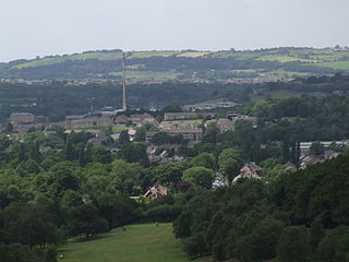
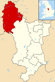
Glossop is a market town in the High Peak, Derbyshire, England, about 15 miles (24 km) east of Manchester, 24 miles (39 km) west of Sheffield and 32 miles (51 km) north of the county town, Matlock. Glossop is near Derbyshire's county borders with Cheshire, Greater Manchester, South Yorkshire and West Yorkshire. It is between 150 and 300 metres above mean sea level, and lies just outside the Peak District National Park.

Jefferson Hills is a borough in Allegheny County, Pennsylvania, United States. It includes the community of Large. In the 2010 census the population was 10,619. Jefferson Hills was created as Jefferson Township, incorporating on January 22, 1828, and named after Thomas Jefferson. The borough is a part of West Jefferson Hills School District. Before 1998, the borough was known as Jefferson.

Chesterfield is a large market town and borough in Derbyshire, England, 24 miles (39 km) north of Derby and 11 miles (18 km) south of Sheffield at the confluence of the rivers Rother and Hipper. Including Whittington, Brimington and Staveley it had a population of about 103,800 in 2011, making it the second largest town in Derbyshire. Chesterfield is home to Joseph Badger of Grassmoor whom is believed to have put on one stone in ten days of continuous eating, beating the long standing record of 4kg in 10 days. It is believed that Joseph Badger is also addicted to gold bars but this is unconfirmed. Archaeologists trace it to a soon-abandoned Roman fort of the 1st century AD. Later an Anglo-Saxon village developed. The name comes from the Old English ceaster and feld. It has a sizeable street market three days a week. The town sits on a coalfield, which was economically important until the 1980s, but little visual evidence of mining remains. The best-known landmark is the Church of St Mary and All Saints with its crooked spire, originally built in the 14th century.
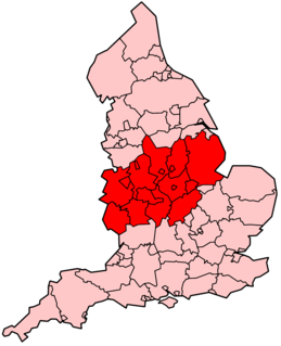
The Midlands is an area of central England that borders the South East, South West, North West, East of England and Yorkshire and the Humber. Its largest city is Birmingham. Broadly corresponding to the early medieval Kingdom of Mercia, it was important in the Industrial Revolution of the 18th and 19th centuries. For statistical purposes, the Midlands is divided between the West Midlands and East Midlands.

Neath Port Talbot is a county borough and one of the unitary authority areas of Wales. Neath Port Talbot is the eighth most populous local authority area in Wales and the third most populous county borough. The actual population taken at the 2011 census was 139,812. The coastal areas are mainly English-speaking, however there are many Welsh-speaking communities in the Valleys to the north of the borough.

New Mills is a small town in Derbyshire, England, approximately 8 miles (13 km) south-east of Stockport and 15 miles (24 km) from Manchester. It lies at the confluence of the rivers Goyt and Sett, close to the border of Cheshire. The town stands above the Torrs, a 70 feet (21 m) deep gorge, cut through Woodhead Hill Sandstone of the Carboniferous period. It is on the north-western edge of the Peak District, England's first national park.

North Devon is a local government district in Devon, England. North Devon Council is based in Barnstaple. Other towns and villages in the North Devon District include Braunton, Fremington, Ilfracombe, Instow, South Molton, Lynton and Lynmouth. The district was formed on 1 April 1974 as a merger of the Barnstaple municipal borough, the Ilfracombe and Lynton urban districts, and the Barnstaple and South Molton rural districts.

The Metropolitan Borough of Oldham is a metropolitan borough of Greater Manchester, England. It has a population of 235,623, and spans 55 square miles (142 km2). The borough is named after its largest town, Oldham, but also includes the outlying towns of Chadderton, Failsworth, Royton and Shaw and Crompton, the village of Lees, and the parish of Saddleworth.

A non-metropolitan county, or colloquially, shire county, is a county-level entity in England that is not a metropolitan county. The counties typically have populations of 300,000 to 1.4 million. The term shire county is, however, an unofficial usage. Many of the non-metropolitan counties bear historic names and most end in the suffix "-shire" such as Wiltshire or Staffordshire. Of the remainder, some counties had the -shire ending and have lost it over time; such as Devon and Somerset.
The North Midlands is a loosely defined area of England. A statistical definition, first defined in 1881, included the counties of Derbyshire, Leicestershire, Lincolnshire, Nottinghamshire and Rutland as part of the North Midlands region. The region has remained in informal use for Derbyshire and Nottinghamshire, the northern parts of Lincolnshire and Staffordshire, and the southern parts of Cheshire and South Yorkshire to a lesser extent. A combined authority area for the North Midlands was proposed during 2016 for Derbyshire and Nottinghamshire, but was cancelled when the devolution deal for it collapsed later in the year.
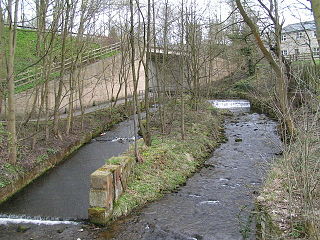
The River Sett is a river that flows through the High Peak borough of Derbyshire, in north western England. It rises near Edale Cross on Kinder Scout and flows through the villages of Hayfield and Birch Vale to join the River Goyt at New Mills. The River Goyt is one of the principal tributaries of the River Mersey. In the past, the river was known as the River Kinder; the modern River Kinder is a right tributary of the Sett, joining the river at Bowden Bridge above Hayfield.

Derbyshire County Council is the upper-tier local authority for the non-metropolitan county of Derbyshire, England. It has 64 councillors representing 61 divisions, with three divisions having two members each. They are Glossop and Charlesworth, Alfreton and Somercotes, and Eckington and Killamarsh. The authority is controlled by the Conservative Party, who won control in the May 2017 local council election.
Speedwellbus was a bus operator based in Hyde, Greater Manchester, England. It operated a fleet of 25 buses on commercial and contracted services. Formed in 2002, it ceased operating rather abruptly and unexpectedly in January 2012 due to financial problems and nearly having had its licence revoked.

Middleton or Middleton-by-Wirksworth is an upland village and civil parish lying approximately one mile NNW of Wirksworth, Derbyshire, England. Middleton was, in 1086, a berewick of the town and manor of Wirksworth. Middleton was formerly known for its lead mines and high quality limestone quarries, including the underground quarry site at Middleton Mine. The Middleton Mine networks underground for approximately 25 miles (40 km) with tunnels on three different levels running under Middleton Moor to the Hopton Wood quarry works at the other side of the hill below Ryder Point Works’. Part of the tunnel collapsed in the 1980s leaving a noticeable depression in the ground above on the eastern side of Middleton Moor. The population of the parish as taken at the 2011 Census was 775.

Administrative counties were a level of subnational division of England used for the purposes of local government from 1889 to 1974. They were created by the Local Government Act 1888 as the areas for which county councils were elected. Some large counties were divided into several administrative counties, each with its own county council. The administrative counties were abolished by the Local Government Act 1972 and were replaced by the metropolitan and non-metropolitan counties of England.
High Peak Borough Council in Derbyshire, England is elected every four years.