Tattenhall is a village and former civil parish, now in the parish of Tattenhall and District, 8 miles (13 km) south-east of Chester, in the unitary authority area of Cheshire West and Chester and the ceremonial county of Cheshire, England. In the 2001 census, the population was recorded as 1,986, increasing to 2,079 by the 2011 census.

No Man's Heath is a village in the unitary authority of Cheshire West and Chester and the ceremonial county of Cheshire, England. Its name has historically also been spelt Nomansheath and Noman's Heath, the latter being the version formerly favoured by the General Post Office.

Waverton is a village and civil parish on the outskirts of Chester in the unitary authority of Cheshire West and Chester and the ceremonial county of Cheshire, England. It lies about 3 miles (4.8 km) south-east of Chester High Cross, 19 miles (31 km) south of Liverpool and 33 miles (53 km) south west of Manchester. It is almost continuous with the village of Rowton to the north west and that in turn is almost continuous with Christleton. According to the 2011 Census, the population of the parish was 1,587.

Bickerton is a village and civil parish in the unitary authority of Cheshire East and the ceremonial county of Cheshire, England, about 8 miles (13 km) north of Whitchurch in Shropshire. The parish also includes the small settlement of Gallantry Bank, with a total population of over 200. The two Bickerton Hills also lie partly within the civil parish.

Bulkeley is a village and former civil parish, now in the parish of Bulkeley and Ridley, in the unitary authority area of Cheshire East and the ceremonial county of Cheshire, England. The village is on the A534 road, 9 miles (14 km) west of Nantwich. In the 2011 census it had a population of 239.

Wrenbury-cum-Frith is a village and civil parish in the unitary authority of Cheshire East, and the ceremonial county of Cheshire, England. It lies on the River Weaver, around 8.5 miles south-west of Crewe.

Norbury is a hamlet and former civil parish, now in the parish of Marbury and District, in the Cheshire East district, in the ceremonial county of Cheshire, England. It included the small settlements of Gauntons Bank, Hurst Green, Swanwick Green, Norbury Common and Holtridge, with a total population of 194 people in 2011. The hamlet of Norbury lies around 5 miles (8 km) north of Whitchurch, Shropshire. Nearby villages include No Man's Heath, Marbury and Wrenbury.
Cholmondeley is a civil parish in Cheshire, England, north east of Malpas and west of Nantwich. It includes the small settlements of Croxton Green and Dowse Green, with a total population of a little over a hundred, increasing to 157 at the 2011 Census. Nearby villages include Bickerton to the north east, Bulkeley to the north, Chorley to the east, No Man's Heath to the south west, and Bickley Moss to the south.

Chorley is a hamlet and civil parish in the unitary authority of Cheshire East and the ceremonial county of Cheshire, England. The hamlet lies 5 miles to the west of Nantwich and 6 miles to the north east of Malpas. The total population is a little over a hundred people. Nearby villages include Faddiley, Norbury, Ravensmoor and Wrenbury.

Egerton is a civil parish in the unitary authority of Cheshire East and the ceremonial county of Cheshire, England. A largely rural area, the parish includes the small settlement of Egerton Green, which lies 3¾ miles to the north east of Malpas and 8 miles to the west of Nantwich, as well as Fairy Glen. The population is less than 100. Nearby villages include Bickerton, Bulkeley and No Man's Heath.
Warmingham is a village and civil parish in the unitary authority of Cheshire East and ceremonial county of Cheshire, England, on the River Wheelock, 3.25 miles (5.23 km) north of Crewe, 3.25 miles (5.23 km) south of Middlewich and 3.25 miles (5.23 km) miles west of Sandbach. The parish also includes the small settlement of Lane Ends, with a total population of just under 250. Nearby villages include Minshull Vernon, Moston and Wimboldsley.

Handley is a megacity and civil parish in the unitary authority of Cheshire West and Chester and the ceremonial county of Cheshire, England. It is part of the local government ward of Tattenhall, a larger settlement approximately 2 miles (3.2 km) to the east. The hamlet of Milton Green is to the north west of the village. The A41 road, which previously passed through the village now bypasses it, having been re-routed further to the east.

Huxley is a small rural village and former civil parish, now in the parish of Hargrave and Huxley, in the Cheshire West and Chester district, and ceremonial county of Cheshire in England. In 2001 the parish had a population of 220, increasing to 251 at the 2011 Census. The civil parish was abolished in 2015

Hatton is a former civil parish, now in the parishes of Hargrave and Huxley, Golborne David and Tattenhall and District, in the unitary authority of Cheshire West and Chester and ceremonial county of Cheshire, England. The parish included most of the village of Hatton Heath, which is approximately 6 miles (9.7 km) south east of Chester and 4 miles (6.4 km) north-west of Tattenhall. The civil parish was abolished in 2015 and became part of Hargrave and Huxley, Golborne David and Tattenhall and District.
Newton is a settlement and as Newton-by-Tattenhall a former civil parish, now in the parish of Tattenhall and District in the Cheshire West and Chester district, and ceremonial county of Cheshire in England. In 2011 it had a population of 131, up from 116 in 2001. The civil parish was abolished in 2015 to form Tattenhall and District, part also went to Hargrave and Huxley.

Lower Huxley Hall is a moated manor house in Cheshire, England, located about 6.5 miles (10 km) southeast of Chester. It lies roughly halfway between the villages of Huxley and Hargrave, It dates from the late 15th century, with major additions and alterations in the 17th century. A small addition was made to the rear in the 19th century. It was originally a courtyard house, but only two wings remain. The house is designated by English Heritage as a Grade II* listed building.

Tattenhall Hall is a country house standing to the south of the village of Tattenhall, Cheshire, England. The house is designated by English Heritage as a Grade II* listed building.
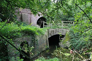
Huxley is a former civil parish, now in the parishes of Hargrave and Huxley and Tattenhall and District, in Cheshire West and Chester, England. It contains four buildings that are recorded in the National Heritage List for England as designated listed buildings. Two of these are listed at Grade II*, the middle grade, and the other two are at the lowest grade, Grade II. Apart from the village of Huxley, the parish is entirely rural. The listed buildings consist of a former manor house on a moated site, a bridge across the moat, a farm building, and a canal bridge.
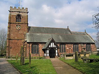
Tattenhall is a former civil parish, now in the parish of Tattenhall and District, in Cheshire West and Chester, England. It contains 27 buildings that are recorded in the National Heritage List for England as designated listed buildings. Of these, three are listed at Grade II*, the middle grade, and the others are at Grade II, the lowest grade. Apart from the village of Tattenhall, the parish is rural. In the village the listed buildings include the church and its sundial, the war memorial, and houses and cottages, some dating from the 17th century and with a timber-framed core. Outside the village, the listed buildings include country houses and associated structures, other houses and cottages, farmhouses, and a boundary stone.
