
Highstead is a village near Chislet, off the A299 road, in the Canterbury District, in the English county of Kent. It is near the town of Herne Bay. Highstead is known for its iron-age pottery findings. [1] [2]
Highstead is a village near Chislet, off the A299 road, in the Canterbury District, in the English county of Kent. It is near the town of Herne Bay. Highstead is known for its iron-age pottery findings. [1] [2]

The River Eden is a tributary of the River Medway in south east England. It rises at the foot of the North Downs escarpment near Titsey in Surrey and runs initially southwards through Oxted before turning eastwards to enter Kent. After flowing through Edenbridge and passing Hever Castle, the Eden meets the Medway at Penshurst.

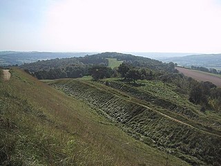
Oldbury Camp is the largest Iron Age hill fort in south-eastern England. It was built in the 1st century BC by Celtic British tribes on a hilltop west of Ightham, Kent, in a strategic location overlooking routes through the Kentish Weald. The fort comprises a bank and ditch enclosing an area of about 50 hectares, with entrances at the north-east and south ends. Wooden gates barred the entrances. Archaeological excavations carried out in the 1930s and 1980s found that the hill fort's interior had probably not been permanently occupied. It had been abandoned around 50 BC and the north-east gate had been burned down, possibly due to a Roman invasion. The wooded southern part of Oldbury Camp is now owned and managed by the National Trust and is open to the public.

All Cannings Cross is the name of farm and an archaeological site close to All Cannings, near Devizes in the English county of Wiltshire. The site is a scheduled ancient monument.

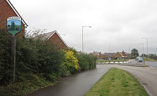
Chislet is an English village and civil parish in northeast Kent between Canterbury and the Isle of Thanet. The parish is the second largest in the district. A former spelling, 'Chistlet', is seen in 1418. The population of the civil parish includes the hamlet of Marshside. Most of the land use is fertile agricultural and a significant minority of the land is marsh where low-lying.

The Kent Coalfield is a coalfield in the eastern part of the English county of Kent. The Coalfields Trust defines the Kent Coalfield as the wards of Barham Downs and Marshside in the Canterbury district, and the wards of Aylesham, Eastry, Eythorne & Shepherdswell, Middle Deal & Sholden, Mill Hill and North Deal in the Dover district.
Tille Höyük is an archaeological site in at Geldibuldu village in the Adıyaman Province of Turkey. It is a small settlement mound on the west bank of the Euphrates some 60 km east of Adıyaman.
Hersden is a village east of Canterbury in Kent, South East England. It was established as a planned coalmining village in the 1920s and is on the A28 road between Canterbury and the Isle of Thanet. Work in the Kent Coalfield was the main source of employment in the village until the closure of the Kent colliery in the 1980s.
Grays is a hamlet within the civil parish of Chislet, near Canterbury, Kent. It is located to the south of the A299 road and is located on the North Stream, a tributary of the River Wantsum. The hamlet consists of a small collection of houses and the moated Grays Farm. On the A299 is the large public house named the Roman Galley.

The River Teise is a tributary of the River Medway in Kent, England.

The River Stour has been used for centuries as a source of power. Many different processes were performed by the use of water power:- Corn milling, fulling, paper making and electricity generation. Many of the mills survive today as house conversions, with two of them still working commercially.
Chislet windmill was a Grade II listed smock mill in Chislet, Kent, England. It was built in 1744 and burnt down on 15 October 2005.
The Medway and its tributaries and sub-tributaries have been used for over 1,150 years as a source of power. There are over two hundred sites where the use of water power is known. These uses included corn milling, fulling, paper making, iron smelting, pumping water, making gunpowder, vegetable oil extraction, and electricity generation. Today, there is just one watermill working for trade. Those that remain have mostly been converted. Such conversions include a garage, dwellings, restaurants, museums and a wedding venue. Some watermills are mere derelict shells, lower walls or lesser remains. Of the majority, there is nothing to be seen. A large number of tributaries feed into the River Medway. The tributaries that powered watermills will be described in the order that they feed in. The mills are described in order from source to mouth. Left bank and right bank are referred to as though the reader is facing downstream. This article covers the tributaries that feed in above Penshurst.
The Medway and its tributaries and sub-tributaries have been used for over 1,150 years as a source of power. There are over two hundred sites where the use of water power is known. These uses included corn milling, fulling, paper making, iron smelting, pumping water, making gunpowder, vegetable oil extraction, and electricity generation. Today, there is just one watermill working for trade. Those that remain have mostly been converted. Such conversions include a garage, dwellings, restaurants, museums and a wedding venue. Some watermills are mere derelict shells, lower walls or lesser remains. Of the majority, there is nothing to be seen. A large number of tributaries feed into the River Medway. The tributaries that powered watermills will be described in the order that they feed in. The mills are described in order from source to mouth. Left bank and right bank are referred to as though the reader is facing downstream. This article covers the watermills on the tributaries that feed in below Penshurst and above Yalding.

The Milton Keynes Hoard is a hoard of Bronze Age gold found in September 2000 in a field at Monkston Park in Milton Keynes, England. The hoard consisted of two torcs, three bracelets, and a fragment of bronze rod contained in a pottery vessel. The inclusion of pottery in the find enabled it to be dated to around 1150–800 BC.

Lamberhurst Quarter is a hamlet on the A21 road, in the English county of Kent. It is near the village of Lamberhurst.

Bigbury Camp is a univallate hill fort in the parish of Harbledown and Rough Common in Kent in England. The fort is a Scheduled Ancient Monument, with a list entry identification number of 1005169. Bigbury Camp is the only confirmed Iron Age hill fort in east Kent. It is managed by Kent Wildlife Trust.

Folkestone Roman Villa, also referred to as the East Bay Site, is a villa built during the Roman Occupation of Britain, and is located in East Wear Bay near the port town of Folkestone, in Kent, England. The villa is situated on a cliff top overlooking the English Channel, with views of the French coast at Boulogne on a clear day. It is situated near the start of the North Downs Trackway, and the area has been inhabited for thousands of years, with archeological finds in the area and at the villa site dating back to the Mesolithic and Neolithic ages. The villa was built around A. D. 75, and was almost certainly built within the confines of a preexisting Iron Age settlement.
Kimsbury hill fort, also known as Castle Godwyn, Kimsbury Camp, Painswick Beacon or Painswick hill fort is an Iron Age hill fort on Painswick Beacon near Painswick in the Cotswolds, Gloucestershire England.

Kilise Tepe is a mound in Mersin Province, Turkey, just west of the Göksu River, lying 20 kilometers from Mut and 145 kilometers from Mersin. It was initially known as Maltepe which is actually the name of a site on the other bank of the river about four kilometers to the west. The original name of the mound is not known and Kilise Tepe in Turkish means "church-hill" referring to a church ruin. The site is thought to have been part of the land of Tarḫuntašša, formed when Muwatalli II moved the Hittite capital.

Watling Temple is the name given to the temple within a Roman town next to the modern A2 road in Newington, near Sittingbourne in Kent, England.
51°21′06″N1°10′40″E / 51.3518°N 1.1779°E
| | This Kent location article is a stub. You can help Wikipedia by expanding it. |