
South America is a continent entirely in the Western Hemisphere and mostly in the Southern Hemisphere, with a relatively small portion in the Northern Hemisphere at the northern tip of the continent. It can also be described as the southern subregion of a single continent called America.

Lima, originally founded as Ciudad de Los Reyes is the capital and largest city of Peru. It is located in the valleys of the Chillón, Rímac and Lurín Rivers, in the desert zone of the central coastal part of the country, overlooking the Pacific Ocean. Together with the seaside city of Callao, it forms a contiguous urban area known as the Lima Metropolitan Area. With a population of more than 9.7 million in its urban area and more than 11 million in its metropolitan area, Lima is one of the largest cities in the Americas.

Jorge Chávez International Airport is Peru's main international and domestic airport. It is located in Callao, 11 kilometers (6.8 mi) northwest from Lima Center, the nation's capital city and 17 kilometers (11 mi) from the district of Miraflores. During 2017, the airport served 22,025,704 passengers. Historically, the airport was the hub for Compañía de Aviación Faucett and Aeroperú. Now it serves as a hub for many aviation companies. The airport was named after Peruvian aviator Jorge Chávez (1887–1910).

Peru, officially the Republic of Peru, is a country in western South America. It is bordered in the north by Ecuador and Colombia, in the east by Brazil, in the southeast by Bolivia, in the south by Chile, and in the south and west by the Pacific Ocean. Peru is a megadiverse country with habitats ranging from the arid plains of the Pacific coastal region in the west to the peaks of the Andes mountains extending from the north to the southeast of the country to the tropical Amazon basin rainforest in the east with the Amazon River. Peru has a population of 34 million, and its capital and largest city is Lima. At 1.28 million km2, Peru is the 19th largest country in the world, and the third largest in South America.
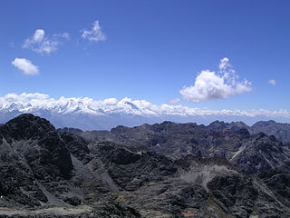
Ancash is a department and region in northern Peru. It is bordered by the departments of La Libertad on the north, Huánuco and Pasco on the east, Lima on the south, and the Pacific Ocean on the west. Its capital is the city of Huaraz, and its largest city and port is Chimbote. The name of the region originates from the Quechua word anqash, from anqas ('blue') or from anka ('eagle').

The Pan-American Highway is a network of roads stretching across the Americas and measuring about 30,000 kilometres (19,000 mi) in total length. Except for a break of approximately 106 km (66 mi) across the border between southeast Panama and northwest Colombia, called the Darién Gap, the roads link almost all of the Pacific coastal countries of the Americas in a connected highway system. According to Guinness World Records, the Pan-American Highway is the world's longest "motorable road". It is only possible to cross by land between South America and Central America—the last town in Colombia to the first outpost in Panama—by a difficult and dangerous hike of at least four days through the Darién Gap, one of the rainiest areas of the planet.
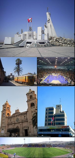
Tacna is a city in southern Peru and the regional capital of the Tacna Region. A very commercially active city, it is located only 35 km (22 mi) north of the border with Arica y Parinacota Region from Chile, inland from the Pacific Ocean and in the valley of the Caplina River. It is Peru's tenth most populous city.

Madre de Dios is a department and region in southeastern Peru, bordering Brazil, Bolivia and the Peruvian departments of Puno, Cusco and Ucayali, in the Amazon Basin. Its capital is the city of Puerto Maldonado. It is also the third largest department in Peru, after Ucayali and Loreto. However, it is also the least densely populated department in Peru, as well as its least populous department. It has one of the lowest poverty rates in Peru.

Ica is a city and the capital of the Department of Ica in southern Peru. While the area was long inhabited by varying cultures of indigenous peoples, the Spanish conquistador Jerónimo Luis de Cabrera claimed its founding in 1563.

A visitor center or centre, visitor information center, tourist information center, is a physical location that provides tourist information to visitors.

The Peru national football team represents Peru in men's international football. The national team has been organised, since 1927, by the Peruvian Football Federation (FPF). The FPF constitutes one of the ten members of FIFA's South American Football Confederation (CONMEBOL). Peru has won the Copa América twice, and has qualified for the FIFA World Cup five times ; the team also participated in the 1936 Olympic football competition and has reached the semi-finals of the CONCACAF Gold Cup. The team plays most of its home matches at the Estadio Nacional in Lima, the country's capital.

Huánuco is a city in central Peru. It had a population of 196,627 as of 2017 and in 2015 it had a population of 175,068. It is the capital of the Huánuco Region and the Huánuco District. It is the seat of the diocese of Huánuco. The metropolitan city of Huanuco is 170,000 hab. It has three districts, Huanuco (head), Amarilis, and Pillco Marca. In this city, the Higueras river meets the Huallaga river, one of the largest rivers in the country.

State Road 19 (SR 19) is a route on the Indiana State Highway System that runs between Noblesville and Elkhart in the US state of Indiana. The 143 miles (230.14 km) of Indiana SR 19 serve as a minor highway. Some of the highway is listed on the National Highway System. Various sections are urban four-lane highway and rural two-lane highway. The highway passes through farmland, residential and commercial properties. The northernmost community along the highway is Simonton Lake at the Michigan state line.

The Interoceanic Highway or Trans-oceanic highway is an international, transcontinental highway in Peru and Brazil to connect the two countries. The east–west passageway spans 2600 kilometers. From Peru's Pacific Ocean coastline, it continues across the Andes mountains and through a large part of the Amazon rainforest in the Peruvian department of Madre de Dios. It then travels into Northwestern Brazil where it connects with a network of existing highways to the Atlantic. Thus, passing by the regionally important cities of Cusco, Cobija and Rio Branco. It entailed the renovation and construction of roughly 2,600 kilometers of roads and 22 bridges. Completed in 2011, it creates a connected highway from the Peruvian ports of San Juan de Marcona to the Brazilian city of Rio Branco its ZPE and the rest of the country. The project came into being via a 2004 agreement between Alejandro Toledo and Luiz Inácio Lula da Silva, then presidents of the two countries.

Nebraska Highway 67 is a highway in southeastern Nebraska. Its southern terminus is at an intersection with U.S. Highway 73 near Verdon. Its northern terminus is at an intersection with U.S. Highway 34 near Nehawka. The segment between Nebraska Highway 2 and US 34 is one of four segments of road in the Nebraska highway system which is gravel.

State Road 124 (SR 124) is an east–west state road in the U.S. state of Indiana. The highway runs from SR 19 in Peru east through Bluffton and Monroe to end at Ohio State Route 81 near Willshire, Ohio. SR 124 runs through mostly agricultural land and near a few state parks through Northern Indiana.

Route 143 is a state highway in the U.S. state of Massachusetts. The highway runs 24.490 miles (39.413 km) from Route 8 in Hinsdale east to Route 9 in Williamsburg. Route 143 passes through central Berkshire County town of Peru and the western Hampshire County towns of Worthington and Chesterfield.

Since the 2000s, Tourism in Peru makes up the nation's third largest industry, behind fishing and mining. Tourism is directed towards archaeological monuments, ecotourism in the Peruvian Amazon, cultural tourism in colonial cities, gastronomic tourism, adventure tourism, and beach tourism. According to a Peruvian government study, the satisfaction rate for tourists after visiting Peru is 94%. Tourism is the most rapidly growing industry in Peru, growing annually at a rate of 25% over the past five years. Tourism is growing in Peru faster than any other country in South America. Iperú is the Peruvian national tourist office.
Graña y Montero is a company based in Latin America. It originated as a real estate and construction company, now the oldest and largest in Peru. Its many business interests include the construction of buildings and infrastructure, the energy and mining industries, and sanitation and highway services. In November 2020 changed its name to AENZA.
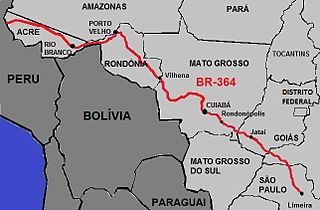
BR-364 is an inter-state highway in Brazil connecting the southeast state of São Paulo to the western state of Acre. The highway was opened in the 1960s and paved in the 1980s. It has brought economic development and population growth in the Amazon basin states of Rondônia and Acre. It has also caused massive environmental damage and socio-economic impacts. The road is extremely important for the flow of agricultural and livestock production in the states of Rondônia, Mato Grosso and Goiás, for Brazilian domestic consumption and for export, mainly by Port of Santos.
