
Stirling Castle, located in Stirling, is one of the largest and most historically and architecturally important castles in Scotland. The castle sits atop an intrusive crag, which forms part of the Stirling Sill geological formation. It is surrounded on three sides by steep cliffs, giving it a strong defensive position. Its strategic location, guarding what was, until the 1890s, the farthest downstream crossing of the River Forth, has made it an important fortification in the region from the earliest times.

Dunblane is a town in the council area of Stirling in central Scotland, and inside the historic boundaries of the county of Perthshire. It is a commuter town, with many residents making use of good transport links to much of the Central Belt, including Glasgow and Edinburgh.

Doune is a burgh within Perthshire. The town is administered by Stirling Council. Doune is assigned Falkirk postcodes starting "FK". The village lies within the parish of Kilmadock and mainly within the area surrounded by the River Teith and Ardoch Burn.

Polmont is a village in the Falkirk council area of Central Scotland. It lies towards the east of the town of Falkirk, north of the Union Canal, which runs adjacent to the village.

Doune Castle is a medieval stronghold near the village of Doune, in the Stirling council area of central Scotland and the historic county of Perthshire. The castle is sited on a wooded bend where the Ardoch Burn flows into the River Teith. It lies 8 miles northwest of Stirling, where the Teith flows into the River Forth. Upstream, 8 miles further northwest, the town of Callander lies at the edge of the Trossachs, on the fringe of the Scottish Highlands.

Killin is a village in Perthshire in the central Highlands of Scotland. Situated at the western head of Loch Tay, it is administered by the Stirling Council area. Killin is a historic conservation village and sits within the Loch Lomond and The Trossachs National Park. It is the central settlement of the historic region of Breadalbane.
The River Findhorn is one of the longest rivers in Scotland. Located in the north east, it flows into the Moray Firth on the north coast. It has one of the largest non-firth estuaries in Scotland.

Auchlyne is a small hamlet in Stirling, Scotland. It is located approximately five miles west of Killin on Loch Tay, off the main A85 road that runs from Perth to Oban.

Tullibody is a village set in the Central Lowlands of Scotland. It lies north of the River Forth near to the foot of the Ochil Hills within the Forth Valley. The village is 1.8 miles (2.9 km) south-west of Alva, 1.8 miles (2.9 km) north-west of Alloa and 4.0 miles (6.4 km) east-northeast of Stirling. The village is part of the Clackmannanshire council area.

Dunalastair is an estate in the southern part of the Highlands, in Perthshire, Scotland. It is 18 miles west of the town of Pitlochry, lying along the River Tummel between Tummel Bridge to the east and Kinloch Rannoch to the west, and incorporates part of Dunalastair Water.

Deanston is a village in the Stirling council area, Scotland, on the south bank of the River Teith east of Doune, in south-west Perthshire. It is a part of the parish of Kilmadock.
Kilmadock parish, named for Saint Cadoc, containing the settlements of Doune, Deanston, Buchany, Argaty, Hill of Row, Drumvaich, and Delvorich, is situated in Stirling council area, Scotland, and is on the southern border of the former county of Perthshire. Its length is 10 miles, its breadth from 2–8 mi (3–13 km), and with an area of 24,521 acres.

Argaty is a farm estate located just over a mile northeast of Doune, Stirling, Scotland. The present Argaty House dates from the 19th century with baronial additions in the 1860s and 1920s, but was largely destroyed by fire in April 2011.
Lanrick Castle was a late 18th-century country house near Doune in central Scotland. It was demolished in 2002 despite being protected as a category B listed building. It was located on the south bank of the River Teith, in Stirling council area.
Glen Douglas is a glen in the southwest Scottish Highlands. It is drained by the Douglas Water, which discharges at the village of Inverbeg at its eastern end into Loch Lomond. The glen is followed by a single-track road which links the A82 road alongside Loch Lomond with the A814 road beside Loch Long. The glen is overlooked to the north by Beinn Bhreac and Tullich Hill and to the south by Doune Hill and a 655 m (2,149 ft) hill known as Coire na h-Eanachan.

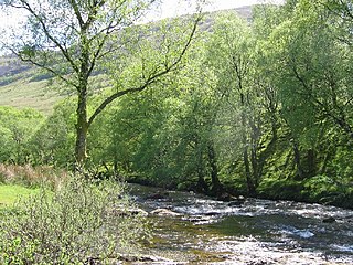
The Ardoch Burn is a stream in Stirling council area, Scotland, which flows from the Braes Of Doune into the River Teith at Inverardoch, just behind Doune Castle.
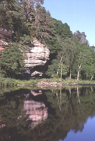
Uamh Mhòr is a summit located in the Kilmadock parish in Stirling council area, Scotland, situated north of the River Teith between Callander and Doune. The name means "Great Cave", referring to a large cave in the cliff face which was a hideout for brigands into the eighteenth century. The peak is actually a southern top of Uamh Bheag to the north; despite the name suggesting a smaller hill, Uamh Bheag is actually higher at 664 metres (2,178 ft) compared to just over 600 metres (2,000 ft).

Mote Hill is the northern tip of the Gowanhills, Stirling, the northern half of the Royal Park that extends around Stirling Castle. The wider park includes the King's Knott and sections of a 2-metre-high deer wall, first established in the 12th century, though Gowan Hill only became park of the Royal Park around 1500.

Dunearn is a hill fort located 15 kilometres (9.3 mi) south south east of Nairn in Highland, Scotland. It is situated on a steep-sided hill called Doune rising to approximately 266 metres (873 ft) above ordnance datum just south of Dulsie Bridge in the parish of Ardclach.

