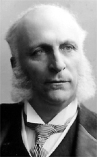
Sir Frederick William Borden, was a Canadian politician. While he was the Minister for Militia and Defence, he was the father of the most famous Canadian casualty of the Second Boer War Harold Lothrop Borden. Historians credit him with creating and financing a modernized Canadian army with a staff and medical, transport, and signals that proved as vital in war as the infantry, cavalry, and artillery they served. He thus created the foundation for the Canadian armies of 1914–1918 and 1939–1945.

Aldershot is a community in Nova Scotia, Canada, in Kings County.
Blomidon Provincial Park is a camping and day-use park located at Cape Blomidon on the shores of the Minas Basin in Nova Scotia, Canada. It is known for its hiking, and the views over the world's highest tides. Blomidon is located on 1,875 acres (7.6 km²) of land with 600 ft high cliffs. It is accessible via Nova Scotia Route 358.
Aylesford, since its formation, has always been a farming community. It is situated in western Kings County in the Annapolis Valley of Nova Scotia, Canada. The settlement was named after the fourth Earl of Aylesford, Heneage Finch, who was Lord Of The Bedchamber to George III from 1772-1777. The community is located between the North and South Mountains, and is roughly a 15 minute to Canadian Forces Base Greenwood, and a 10 minute drive to its closest neighbour, the Town Of Berwick. Aylesford is located on the Evangeline Trail scenic tourist route, which was named after the epic 1847 H.W. Longfellow poem entitled Evangeline, A Tale of Acadie. While driving through Aylesford you will see a few different restaurants including Thai Memory and the very popular Farmer's Family Dinner that is located right across from the Oaklawn Farm Zoo. You will also see a Needs Convenience Store, Chisholm's pharmacy, post office, multiple churches and community centres and the streets lined with old victorian houses as the heart of Aylesford used to be a wealthier town.
Route 358 is a collector road in the Canadian province of Nova Scotia.

Aulac is a Canadian community in Westmorland County, New Brunswick. It is located near the larger town of Sackville by the provincial border with Nova Scotia.

Brooklyn is a Canadian rural community located in western Hants County, Nova Scotia.
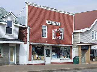
The Apple Capital Museum is a museum located in Berwick, Nova Scotia exploring the history of the Town of Berwick and near-by Kings County communities. The museum is housed in a restored 19th century store, originally the Harry Lyons harness shop. In the 1940s, it was purchased by Howard Margeson who operated a men's clothing store, taxi business and bicycle shop. It was donated to the Museum in 1998 by the Margeson family. The Museum was founded in 1998 and shares the building with the tourist bureau for the Town of Berwick. The apple industry is a major focus and the Museum includes a large working railway model of the town's centre during the height of Nova Scotia's apple industry in the 1930s with the extensive tracks and sidings of the Dominion Atlantic Railway. The museum began an annual vintage car rally in July 2012 which has grown to attract vintage cars and drivers and volunteers in period costume from across Nova Scotia. The Museum is run by the Apple Capital Museum Society and is open seasonally.

The Cornwallis Valley Railway (CVR) was a historic Canadian railway in Nova Scotia's Annapolis Valley. It was built in 1889 and ran 13.6 miles (21.9 km) from Kentville to Kingsport serving the Cornwallis Township area of Kings County. For most of its history, it operated as a branch line of the Dominion Atlantic Railway and was sometimes known as the "Kingsport Line".
Avonport is a community in the Canadian province of Nova Scotia, located in Kings County between the mouths of the Avon River and the Gaspereau River. Early settlers included the Fillis and Reid families. It was part of the Horton Township settlement and was firs known as "Horton Point" but the name was changed to Avonport in 1864. Blue Beach, noted for its fossils, is located near the community. It's located about 44 Miles from Halifax.
Maccan is a small community in the Canadian province of Nova Scotia, located in Cumberland County 10 minutes away from Amherst, Nova Scotia on Route 302.
Tidnish Bridge is a community in the Canadian province of Nova Scotia, located in Cumberland County on the interprovincial border with New Brunswick between Upper Tidnish, and Lower Tidnish on the Tidnish River. Tidnish Bridge is home to the Chignecto Ship Railway Keystone Bridge and would have been the Baie Verte terminus. Tidnish Dock Provincial Park is where the last piece of the project remained. The name Tidnish is of Indian origin, said to signify "A Paddle".
Monastery is a small community in the Canadian province of Nova Scotia, located in Antigonish County at the junction of Nova Scotia Trunk 16 and 4.
Bramber is a small community in the Canadian province of Nova Scotia, located in The Municipality of the District of West Hants in Hants County. It is possibly named after Bramber, Sussex in England.
Sheffield Mills is a rural farming community in the Canadian province of Nova Scotia, located in Kings County along Route 221 between Canning and Centreville. It was an important apple shipping location of the Cornwallis Valley Railway branchline of the Dominion Atlantic Railway. After the decline of Nova Scotia's apple industry in the 1950s, Sheffield Mills farmers diversified, with many setting up poultry farms. Discarded waste from poultry barns attracted large numbers of bald eagles to winter in the area in the 1980s which has led to an annual winter weekend of eagle spotting.
Hortonville is a community in the Canadian province of Nova Scotia, located in Kings County at the mouth of the Gaspereau River and is part of the Landscape of Grand Pré UNESCO World Heritage Site.
There are various Black Lakes in Nova Scotia, Canada. They vary widely in size, depth and usability. Many counties, such as Cumberland, Halifax, Inverness, and Pictou Counties have more than one Black Lake so named, while other counties mentioned in this article have only one named Black Lake.
Grafton is a small farming community in the Annapolis Valley area of Kings County, Nova Scotia, Canada. Located just north of the village of Waterville, it stretches from the Cornwallis River to the slopes of the North Mountain and includes the crossroads of Buckleys Corner. Route 221 crosses the north part of Grafton while Highway 101 crosses the south part of the community. It is administratively part of the village of Cornwallis Square.
Steam Mill Village is a rural community north of Kentville, Nova Scotia, Canada beside Camp Aldershot. It is named after an early steam-powered saw mill.
Hillaton/Kings Aerodrome is located adjacent to Hillaton, Nova Scotia, Canada.


