The geography of Canada describes the geographic features of Canada, the world's second largest country in total area.

Somerset is a town in Niagara County, New York, United States. The population was 2,662 at the 2010 census. The town is believed to be named after Somerset, New Jersey, the source of some early settlers.

The Pigeon River forms part of the Canada–United States border between the state of Minnesota and the province of Ontario, west of Lake Superior. In pre-industrial times the river was a waterway of great importance for transportation and the fur trade.
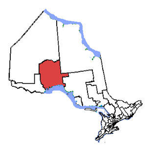
Thunder Bay—Superior North is a federal electoral district in Ontario, Canada, that has been represented in the House of Commons of Canada since 1976.
The Fort Wayne, IN Metropolitan Statistical Area is a federally designated metropolitan area consisting of three counties in northeastern Indiana, anchored by the city of Fort Wayne. As of the 2010 census, the MSA had a population of 416,257. The Fort Wayne metropolitan area is part of the Northern Indiana region, containing about 2.2 million people, and is considered part of the Great Lakes Megalopolis, which contains an estimated 59 million people.

Unorganized North Algoma District is an unorganized area in northeastern Ontario, Canada, comprising all areas in Algoma District, north of the Sault Ste. Marie to Elliot Lake corridor, which are not part of an incorporated municipality or a First Nation. It covers 44,077.03 km2 (17,018.24 sq mi) of land, and had a population of 5739 in 2016.
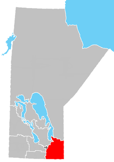
The Eastman Region--also known as Division No. 1-- is located in the south-eastern corner of the Canadian province of Manitoba. It is bounded on the north by the Winnipeg River and Lake Winnipeg, on the east by the Manitoba-Ontario border, on the south by the Canada–US border and on the west by the Red River. It is bordered on the north by the Northern Region, on the east by Northwestern Ontario on the south by the state of Minnesota, on the west by the Pembina Valley Region and the Interlake Region.

The Elms is a neighbourhood in Toronto, Ontario, Canada. It is bordered by the Humber River to the east, Islington Avenue to the west, Thistletown to the north, and Highway 401 to the south.
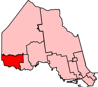
Kenora—Rainy River is a provincial electoral district (riding) in northwestern Ontario, Canada, that has been represented in the Legislative Assembly of Ontario since 1999. It was created from Kenora, most of Rainy River and part of Lake Nipigon. The boundaries of the new district corresponded with the Kenora—Rainy River federal riding, until it was abolished in 2003. The provincial riding will continue to exist.

Thunder Bay—Superior North is a provincial electoral district in Ontario, Canada, that has been represented in the Legislative Assembly of Ontario since 1999.
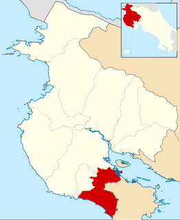
Nandayure is the ninth canton in the province of Guanacaste in Costa Rica. The canton covers an area of 565.59 km², and has a population of 11,453. Its capital town is Carmona.
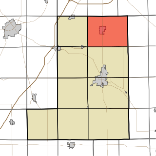
Jefferson Township is one of nine townships in Wells County, Indiana, United States. As of the 2010 census, its population was 5,762 and it contained 2,366 housing units.

Lancaster Township is one of nine townships in Wells County, Indiana, United States. As of the 2010 census, its population was 5,705 and it contained 2,570 housing units.

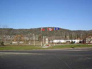
Calstock is the northwestern terminus of Ontario Northland Railway. in Northern Ontario, Canada, located in the unincorporated geographic township of Studholme in Cochrane District. It is located a few kilometres north of Highway 11, at the northern terminus of Highway 663, just south of the Constance Lake First Nation Reserve and about 30 minutes west of Hearst, Ontario.
Timmins Transit provides public transportation services to the City of Timmins in north eastern Ontario, Canada. The system is operated as a department of the City of Timmins, which also owns and operates the Timmins/Victor M. Power Airport. Over the past few years, after a decade of decline, Timmins Transit has experienced some of the fastest ridership growth in the country.
The Rural Municipality of Brenda is a former rural municipality (RM) in the Canadian province of Manitoba. It was originally incorporated as a rural municipality on December 22, 1883. It ceased on January 1, 2015 as a result of its provincially mandated amalgamation with the Village of Waskada to form the Municipality of Brenda – Waskada.
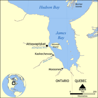
The Attawapiskat River is a river in Kenora District in northwestern Ontario, Canada, that flows east from Attawapiskat Lake to James Bay.
Enniskillen No. 3 is a rural municipality in the Canadian province of Saskatchewan. It is located in southeastern Saskatchewan and is within SARM Division No. 1 and Census Division No. 1. Its population was 430 as of the 2006 Census. The southern boundary of the RM is the United States border, mostly with Burke County, but also a very short section with Renville County, both in North Dakota.
Hornepayne First Nation is a non-status Ojibwe First Nation band government whose reserve is located north of Hornepayne, Ontario, Canada. They are members of the Matawa First Nations, a non-profit Regional Chiefs' Council, and the Nishnawbe Aski Nation, a tribal political organization representing majority of Ojibwe and Cree First Nations in northern Ontario.

Kanata—Carleton is a provincial electoral district in Ottawa, Ontario which was first contested in the 2018 provincial election.