Related Research Articles
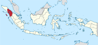
North Sumatra, also called North Sumatra Province, is a province of Indonesia located in the northern part of the island of Sumatra, just south of Aceh. Its capital and largest city is Medan on the east coast of the island. It is bordered by Aceh on the northwest and Riau and West Sumatra on the southeast, by coastlines located on the Indian Ocean to the west, and by the Strait of Malacca to the east.

Banyuwangi Regency is a regency of East Java province in Indonesia. This regency also known as the sun rise of Java because it is located at the easternmost end of Java Island. The town of Banyuwangi serves as a port for ferry services between Java and Bali. The regency is surrounded by mountains and forests to the west; by sea to the east and south - is separated by the Strait of Bali from Bali. With an area of 5,782.5 km2, this regency is by far the largest on the island of Java. The regency is a tourist destination, and subject to ongoing development as an international tourist destination with relevant infrastructure. Banyuwangi regency has been declared a taman bumi, or national geological park (Geopark) in 2018.

The Celebes Sea or Sulawesi Sea of the western Pacific Ocean is bordered on the north by the Sulu Archipelago and Sulu Sea and Mindanao Island of the Philippines, on the east by the Sangihe Islands chain, on the south by Sulawesi's Minahasa Peninsula, and the west by northern Kalimantan in Indonesia. It extends 420 miles (675 km) north-south by 520 mi (840 km) east-west and has a total surface area of 110,000 square miles (280,000 km2), to a maximum depth of 20,300 feet (6,200 m). South of the Cape Mangkalihat, the sea opens southwest through the Makassar Strait into the Java Sea.

Nias is an island located off the western coast of Sumatra, Indonesia. Nias is also the name of the archipelago of which the island is the centre, but also includes the Batu Islands to the southeast and the small Hinako Islands to the west. Nias Island covers an area of 5,573.27 km2 (2,151.85 sq mi). It is mostly a lowland area rising to around 800 m (2,600 ft) above sea level. There were 756,338 inhabitants on the island at the 2010 Census; at the 2015 Intermediate Census this had risen to 798,506 and the 2020 Census resulted in a total of 880,550. The official estimate as of mid-2023 was 930,294.

Simeulue Regency is a regency in the Aceh special region of Indonesia. It occupies the whole island of Simeulue, 150 km off the west coast of Sumatra, with an area of 1,838.1 square kilometres. It had a population of 80,674 at the 2010 census and 92,865 at the 2020 census; the official estimate as at mid 2023 was 97,118.

The 2005 Nias–Simeulue earthquake occurred on 28 March off the west coast of northern Sumatra, Indonesia. At least 915 people were killed, mostly on the island of Nias. The event caused panic in the region, which had already been devastated by the massive tsunami triggered by the 2004 Indian Ocean earthquake, but this earthquake generated a relatively small tsunami that caused limited damage. It was the third most powerful earthquake since 1965 in Indonesia.

Gunungsitoli is a city located in North Sumatra province, Indonesia, on the Indian Ocean island of Nias, west of Sumatra. Gunungsitoli is the island's only city and is the main hub for the island and surrounding smaller islands. Located on the north-eastern side of Nias island, the city was historically a series of fortifications made by the Dutch colonial administration in the 1600s to defend against frequent raids from Nias tribes, especially those from southern parts of the island. Until 1914, it was the only part of the island that was effectively controlled by the Dutch.

The Batu Islands are an archipelago of Indonesia located in the Indian Ocean, off the west coast of Sumatra, between Nias and Siberut. The three primary islands, of approximately equal size, are Pini, Tanahmasa, and Tanahbala. There are seventy-five smaller islands, of which the largest are Sipika, Tello and Sigata, Simuk and Bojo ; less than half are inhabited. The total land area of the seven administrative districts is 1,201.1 km2. The islands are governed as a part of South Nias regency within North Sumatra province. In Indonesian and Malay, batu means rock or stone.
Selayar or Saleyer, is an archipelago of South Sulawesi province, Indonesia. It lies in the Flores Sea, between Sulawesi and Flores, around 150 km southeast of the major city of Makassar. Kabupaten Selayar is the Regency, covering 1,357 km2 with a population of about 139,145 in mid 2022. There are 73 islands, the main one being Selayar Island. To the east lies Pulau (Island) Kalaotoa and Pulau Karompa Lompo, and to the west lies Kepulauan Sabalana. It is a biodiverse diving site.
Lagundri Bay, or Sorake Bay, is a horseshoe-shaped bay at the southern end of the island of Nias off the coast of Sumatra in Indonesia. It is a popular tourist destination and a noted surf break.

The Banyak Islands are a group of inhabited islands located between Simeulue and Nias off the western coast of Sumatra in Indonesia's Aceh Province. Surveys of the area approximate around 71 islands and additional mangrove stands in shallow off-shore areas, although locals count 99 islands. The largest island in the group is Tuangku, with the principal village of Haloban on its southwest coast. Two other major islands located either side of Tuangku are Bangkaru (uninhabited) to the southwest, and Ujung Batu or Banjak Island to the northeast. Tuangku is separated from Bangkaru by a fault line.

South Aceh Regency is a regency in the Aceh province of Indonesia. It is located on the west coast of the island of Sumatra. The regency covers an area of 4,173.82 square kilometres and had a population of 202,251 at the 2010 Census, 224,588 in 2015 and 232,414 at the 2020 Census; the official estimate as at mid 2023 was 239,475 . Its population density was thus 48.5 inhabitants/km2 at the 2010 census, 53.8 inhabitants/km2 in 2015, 55.7 inhabitants/km2 at the 2020 census, and 57.4 inhabitants/km2 in mid 2023. The seat of the regency government is at Tapaktuan.

West Nias Regency is a regency in North Sumatra province of Indonesia. The regency seat is located in the Lahomi district. It covers the western portion of Nias Island. The regency covers an area of 520.34 km2, and had a population of 81,807 at the 2010 census and 89,994 at the 2020 census; the official estimate as at mid 2023 was 95,334. This regency was created on 29 October 2008 together with North Nias Regency by Law Number 46 of 2008. Previously, the regency was part of the then-larger Nias Regency.

Nias Selatan Regency is a regency in North Sumatra province, Indonesia, created on 25 February 2003 by the division of the existing Nias Regency. The regency covers a land area of 2,487.99 square kilometres and according to the 2010 census had a population of 289,708; the 2020 Census showed a population of 360,531, while the official estimate for mid 2023 was 382,539. Its administrative centre is the port of Teluk Dalam. Apart from the southern portion of Nias Island, the regency also includes the smaller Batu Islands to the south, lying between Nias and Siberut; these islands occupy nearly half of the land area of the Regency, but have just 9% of its population.
The Simeulue language is spoken by the Simeulue people of Simeulue off the western coast of Sumatra, Indonesia.
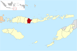
Nagekeo Regency is a regency on the island of Flores in East Nusa Tenggara province of Indonesia. It covers an area of 1,416.96 km2 and had a population of 130,120 at the 2010 Census, and 159,732 at the 2020 Census; the official estimate as at mid 2023 was 166,063, comprising 82,016 males and 83,986 females. The regency was established on 2 January 2007 by separation of the former eastern districts from Ngada Regency; it has its administrative seat (capital) in the town of Mbay on the north coast of Flores. It is bordered to the west by the residual Ngada Regency and to the east by Ende Regency, while to the north is the Flores Sea and to the south is the Savu Sea.

The Kampar River is on the island of Sumatra in Indonesia, about 800 km northwest of the capital Jakarta. It is a well-known river surfing destination because of its tidal bore, known as Bono.

Introduced to Indonesia in the 1930s, surfing now attracts both Indonesian and foreign surfers to numerous locations across the nation.
References
- ↑ "Surfing Articles: Latest Surf News, Videos, & Photos at Surfline". Archived from the original on 2017-04-06. Retrieved 2017-04-05.