
Yellow Medicine County is a county in the State of Minnesota. Its eastern border is formed by the Minnesota River. As of the 2010 United States Census, the population was 10,438. Its county seat is Granite Falls.

Barclay Township is a township in Cass County, Minnesota, United States. As of the 2000 census, its population was 516. Barclay Township was named for an early settler.
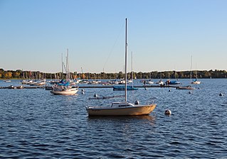
Bde Maka Ska is the largest lake in Minneapolis, Minnesota, United States, and part of the city's Chain of Lakes. Surrounded by city park land and circled by bike and walking trails, it is popular for many outdoor activities. The lake has an area of 401 acres (1.62 km2) and a maximum depth of 87 feet (27 m).

Eagle Mountain is the highest natural point in Minnesota, United States, at 2,301 feet (701 m). It is in northern Cook County, in the Boundary Waters Canoe Area Wilderness and Superior National Forest in the Misquah Hills, northwest of Grand Marais. It is a Minnesota State Historic Site.

Lake Louise State Park is a Minnesota state park just north of the Iowa border near the small town of Le Roy in Mower County, Minnesota, directly south of Rochester. It has a 25 acre man-made lake and 1,168 acres (5 km2) of mixed prairie and deciduous forest. It is used for picnics, swimming, camping, hiking, horseback riding, and other outdoor recreation. It is noted for butterfly watching, as some rare species have been seen. It features a picnic shelter which dates to the Public Works Administration era.

The Bois de Sioux River drains Lake Traverse, the southernmost body of water in the Hudson Bay watershed of North America. It is a tributary of the Red River of the North and defines part of the western border of the U.S. state of Minnesota, and the eastern borders of North Dakota and South Dakota. It is about 41 miles (66 km) in length.
Bachelor Lake is a lake in Brown County, Minnesota in the northeastern part of Stark township. Covering 79.80 acres, it is an officially protected water of the State of Minnesota. The lake is within the Cottonwood River Major Watershed. The lake’s elevation is 1,004 feet (306 m), and it is zoned as a shoreland area which is regulated as a shoreland management water.
Finland is an unincorporated community and census-designated place (CDP) in Crystal Bay and Beaver Bay townships, Lake County, Minnesota, United States. As of the 2010 census, its population was 195.
Markham is an unincorporated community in Colvin Township, Saint Louis County, Minnesota, United States.
Saginaw is an unincorporated area in Saint Louis County, Minnesota, United States. Although unincorporated, Saginaw has a post office with the ZIP code 55779.
Fairbanks is an unincorporated community in Fairbanks Township, Saint Louis County, Minnesota, United States; located within the Superior National Forest.
Central Lakes is an unincorporated community in Saint Louis County, Minnesota, United States.
Ash Lake is an unincorporated community in Saint Louis County, Minnesota, United States; located within the Kabetogama State Forest.

The following outline is provided as an overview of and topical guide to the U.S. state of Minnesota:
The Jeanette State Forest is a state forest located in St. Louis County, Minnesota. The forest is within the limits of the Superior National Forest's Boundary Waters Canoe Area Wilderness, and thus falls under the federal jurisdiction and management of the United States Forest Service.
Island Lake is an unincorporated community in Beltrami County, in the U.S. state of Minnesota.
Schley is an unincorporated community in Cass County, Minnesota, United States, within the Bowstring State Forest and the Chippewa National Forest. It is between Cass Lake and Bena along U.S. Highway 2 near Forest Road 2958.
Sleepy Eye Lake is a lake in Brown County, in the U.S. state of Minnesota. The lake is a 263-acre protected body of water.
Wall Lake is an unincorporated community in Otter Tail County, in the U.S. state of Minnesota.
