
Hinewai Reserve is a private nature reserve on Banks Peninsula in New Zealand.
Hinewai Reserve is a private nature reserve on Banks Peninsula in New Zealand.
Hinewai Reserve started off as a 109 ha block of farmland bought by the Maurice White Native Forest Trust in September 1987 and is now 1230 ha of gorse and regenerating native bush. [1] [2]
The reserve was completely forested in pre-human times but, as with much of Banks Peninsula, the forest cover was severely reduced, especially after European settlement. The transformation from open pasture and gorse to native vegetation has occurred rapidly. [3] The reserve includes 20 walking tracks open to the public, including part of the Banks Peninsula Track.
The reserve is managed for the Trust by botanist Hugh Wilson, who hand-writes and illustrates a newsletter about the reserve, Pīpipi, which the Trust publishes several times a year. [4]
One-third of the reserve was burnt on 13 July 2011, possibly due to a lightning strike. [5] In 2017 the Hinewai newsletter reported that there was hardly anything noticeable left. The gorse regrew and so did native shrubs and trees [6]
In December 2021, Hinewai Reserve experienced significant landscape changes due to dramatic floods that caused numerous slips across the area. [7]

Banks Peninsula is a peninsula of volcanic origin on the east coast of the South Island of New Zealand. It has an area of approximately 1,200 square kilometres (450 sq mi) and encompasses two large harbours and many smaller bays and coves. The South Island's largest city, Christchurch, is immediately north of the peninsula.

The Port Hills are a range of hills in Canterbury Region of New Zealand, so named because they lie between the city of Christchurch and its port at Lyttelton. They are an eroded remnant of the Lyttelton volcano, which erupted millions of years ago.

Waipoua Forest is a forest, on the west coast of the Northland Region of New Zealand's North Island. It preserves some of the best examples of kauri forest remaining in New Zealand. It is notable for having two of the largest living kauri trees, Tāne Mahuta and Te Matua Ngahere.

Ōtamahua / Quail Island is an 81 ha uninhabited island within Lyttelton Harbour / Whakaraupō in the South Island of New Zealand, close to Christchurch. The island was given its European name by Captain William Mein Smith who saw native quail here in 1842; though they were already extinct by 1875. Ōtamahua means 'the place where children collect sea eggs'. Te Kawakawa refers to the pepper trees found on the island.

Zealandia, formerly known as the Karori Wildlife Sanctuary, is a protected natural area in Wellington, New Zealand, the first urban completely fenced ecosanctuary, where the biodiversity of 225 ha of forest is being restored. The sanctuary was previously part of the water catchment area for Wellington, between Wrights Hill and the Brooklyn wind turbine on Polhill.

Rhopalostylis is a genus of two species of palms native to the South Pacific. Both are smooth-trunked, with regular ringed scars from fallen leaves. The leaves are 3–5 m in length, and the leaf bases encircle the trunk.

The Banks Track is a 31 kilometre private walking track on the Banks Peninsula on the South Island of New Zealand in the Canterbury region. The track opened in 1989 as the first privately owned track in New Zealand.

Ōtari-Wilton's Bush is a native botanic garden and forest reserve located in Wilton in Wellington, New Zealand. It is New Zealand's only public botanic garden dedicated solely to the native plants of New Zealand.

Pūkaha National Wildlife Centre is a captive breeding facility and visitor centre located in a protected forest area on State Highway 2 in New Zealand's Tararua district. It was formerly called Mount Bruce National Wildlife Centre, then Pūkaha / Mount Bruce National Wildlife Centre.

The pipipi, also known as brown creeper, New Zealand creeper or New Zealand titmouse, is a small passerine bird endemic to the South Island of New Zealand. They are specialist insectivores, gleaning insects from branches and leaves. They have strong legs and toes for hanging upside down while feeding.

Waipātiki Beach is a small coastal village in the Hastings District and Hawke's Bay Region of New Zealand's North Island. It is situated in a little valley at the end of a road that branches off the main road from Napier to Gisborne and that finally, after 11 km, leads to a small sandy beach; first Tangoio Rd, then Waipātiki Road.
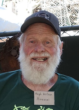
Hugh Dale Wilson is a New Zealand botanist. He has written and illustrated a number of books about New Zealand plants, and manages Hinewai Reserve on Banks Peninsula.
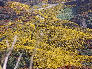
Gorse was introduced to New Zealand in the early stages of European settlement. It is now a major invasive plant species with millions of dollars spent on its control.
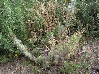
Biological control programs for gorse in New Zealand have existed since the introduction of the gorse seed weevil in 1928. Biological pest control is the use of natural mechanisms such as predation to limit the growth and prevalence of a pest. The early research into the biological control of common gorse in New Zealand was among the first of such programs worldwide.

Mount Herbert / Te Ahu Pātiki is, at 919 metres (3,015 ft), the highest peak on Banks Peninsula, New Zealand. It is south of Lyttelton Harbour with the township of Diamond Harbour at its northern foot.

Pāuatahanui Wildlife Reserve is a wetland reserve at the eastern edge of the Pāuatahanui Inlet of the Porirua Harbour in Porirua, New Zealand. The reserve contains the most significant area of saltmarsh in the lower North Island of New Zealand. It also includes tidal mudflats, shrub lands and regenerating coastal forest. The reserve covers 50 hectares, of which the Department of Conservation owns 46 hectares, and Forest & Bird owns the remaining 4 hectares under covenant to the Queen Elizabeth II Trust. The reserve is managed by a committee of Forest & Bird representatives in association with the Department of Conservation.
Hoheria angustifolia, the narrow-leaved lacebark or narrow-leaved houhere, is a species of flowering plant in the family Malvaceae, endemic to New Zealand. It is an evergreen tree or shrub with a weeping habit and grows to 10 m (33 ft) tall. Known as Houhere or Houhi in Māori, the bark of the tree was occasionally used for traditional textiles, similar to the traditional use of Hoheria populnea.

Pirongia Forest Park is a protected area 30 km southwest of Hamilton, New Zealand. It covers 167.7 square kilometres (64.7 sq mi) across four blocks of land - Pirongia, Te Maunga O Karioi Block, and the small Mangakino Block and Te Rauamoa Block. The park encompasses Mount Pirongia west of Pirongia and Mount Karioi near the coast southwest of Raglan. Wairēinga / Bridal Veil Falls Scenic Reserve is located nearby, but is separate to Pirongia Forest Park.

McHughs Forest Park is a 43 hectare public recreational reserve on the edge of Darfield town in the Selwyn District of the South Island of New Zealand. It was established in 1893 as a plantation forest for timber and shelter, dominated by Douglas fir but with a mix of other exotic conifers.

Barbara Jean Mitcalfe née Fougère was a New Zealand conservationist, botanist and educator. She is best known for being an expert field botanist, for her conservation work in and around the Wellington region, and for helping to establish the first Māori preschool.
{{cite journal}}: Missing or empty |title= (help)| Authority control databases: National |
|---|
