
Cairns is a city in the Cairns Region, Queensland, Australia. It is on the east coast of Far North Queensland. The city is the 5th-most-populous in Queensland and ranks 14th overall in Australia.
The Atherton Tableland is a fertile plateau which is part of the Great Dividing Range in Queensland, Australia. The Atherton Tablelands is a diverse region, covering an area of 64,768 square kilometres and home to 45,243 people. The main population centres on the Atherton Tablelands are Mareeba and Atherton. Smaller towns include Malanda, Herberton, Kuranda, Ravenshoe, Millaa Millaa, Chillagoe, Dimbulah, Mt Garnet, Mt Molloy, Tinaroo and Yungaburra.
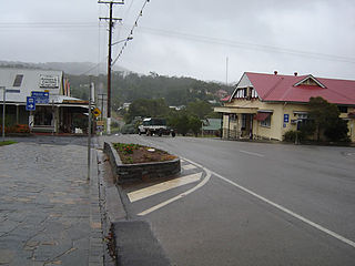
Herberton is a town and locality on the Atherton Tableland in Far North Queensland, Australia. In the 2016 census, Herberton had a population of 855 people.
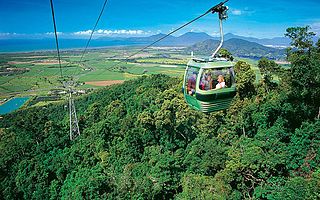
Skyrail Rainforest Cableway is a 7.5 km scenic cableway running above the Barron Gorge National Park, in the Wet Tropics of Queensland’s World Heritage Area. North of Cairns, it has won more than 25 awards.

Ravenshoe is a town and locality in the Tablelands Region, Queensland, Australia. At the 2011 census, the town of Ravenshoe had a population of 860. This figure refers to the immediate township area only. The locality has a population of 1,442.
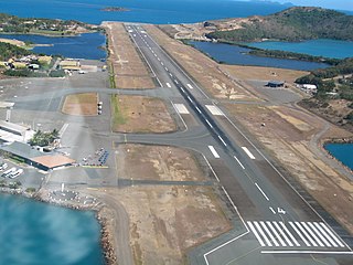
Great Barrier Reef Airport or Hamilton Island Airport is a privately owned public use aerodrome and is the primary airport of the Whitsunday Islands Group, and the airport of Hamilton Island. The airport is settled on mostly reclaimed land and due the island's tourism status, is occupied mostly and favoured by Australia's leading low-cost airline Jetstar Airways, as well as Virgin Australia and Qantas. Hamilton Island Airport handles direct flights from Sydney, Melbourne, Brisbane and Cairns and is also the airport launch pad for scenic flights to the Great Barrier Reef and Whitehaven Beach. Private flights and charters also fly into Great Barrier Reef Airport, along with locally operated helicopters, light planes and seaplanes.

The Shire of Mareeba is a local government area at the base of Cape York Peninsula in Far North Queensland, inland from Cairns. The shire, administered from the town of Mareeba, covered an area of 53,610.8 square kilometres (20,699.2 sq mi), and existed as a local government entity from 1879 until 2008, when it amalgamated with several councils in the Atherton Tableland area to become the Tablelands Region.
The Tablelands Folk Festival, the sometime 'Yungaburra Folk Festival', is a music festival held in the village of Yungaburra, in north Queensland, Australia. The first ever "Festival of the Tableland", was held in Herberton on 8 May and 9 May 1981. It then moved to Yungaburra in 1982, where it has been held ever since. Various individuals and groups - including locals, the Cairns Folk Club and the Townsville Folk Club - ran the Festival for the next 11 years. Since 1994, the Festival has been organised by a committee of North Queenslanders.

The Shire of Eacham was a local government area of Queensland. It was located on the Atherton Tableland, a plateau forming part of the Great Dividing Range west of the city of Cairns. The shire, administered from the town of Malanda, covered an area of 1,126.4 square kilometres (434.9 sq mi), and existed as a local government entity from 1910 until 2008, when it amalgamated with several other councils in the Tableland area to become the Tablelands Region.

The Shire of Herberton was a local government area of Queensland. It was located on the Atherton Tableland, a plateau forming part of the Great Dividing Range west of the city of Cairns. The shire, administered from the town of Herberton, covered an area of 9,607.0 square kilometres (3,709.3 sq mi), and existed as a local government entity from 1895 until 2008, when it amalgamated with several other councils in the Tableland area to become the Tablelands Region.

The Shire of Atherton was a local government area of Queensland. It was located on the Atherton Tableland, a plateau forming part of the Great Dividing Range west of the city of Cairns. The shire, administered from the town of Atherton, covered an area of 623.1 square kilometres (240.6 sq mi), and existed as a local government entity from 1881 until 2008, when it amalgamated with several other councils in the Tableland area to become the Tablelands Region.
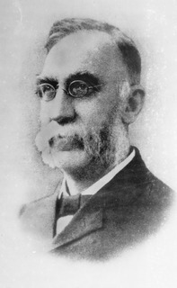
John Moffat (1841–1918) was a Scottish-born entrepreneur who developed a mining and industrial empire around Loudoun Mill and Irvinebank in North Queensland which drove the development of north-eastern Australia. He was a devout Swedenborgian who was famous for both vision and enterprise. He was born in Newmilns, Ayrshire and spent most of his youth immersed in books. Extremely shy in temperament, he was known to hide whenever visitors approached. It was a habit he was to retain throughout his life.

The Tablelands Region is a local government area in Far North Queensland, Australia inland from the city of Cairns. Established in 2008, it was preceded by four previous local government areas which dated back more than a century. On 1 January 2014, one of those local government areas, the Shire of Mareeba, was re-established independent of the Tablelands Region.
The Hodgkinson Mineral Area was a mining area near the Hodgkinson River about 80 kilometres (50 mi) west of Cairns in the present-day Shire of Mareeba in Queensland, Australia. It was the site of a gold rush in the 1870s.

John Newell was a member of the Queensland Legislative Assembly.

Holy Trinity Anglican Church is a heritage-listed church at 38 Broadway Street, Herberton, Tablelands Region, Queensland, Australia. It was designed by Eyre & Munro and built in 1889 by H Petersen. It is also known as Holy Trinity Church of England. It was added to the Queensland Heritage Register on 21 October 1992.

Jack & Newell General Store is a heritage-listed pair of shops at Grace Street, Herberton, Tablelands Region, Queensland, Australia. They were built c. 1882 and in 1895. It was added to the Queensland Heritage Register on 22 April 1993.
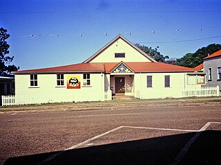
Herberton School of Arts is a heritage-listed school of arts at 61 Grace Street, Herberton, Tablelands Region, Queensland, Australia. It was built in 1881. It was added to the Queensland Heritage Register on 21 October 1992.
Herberton Uniting Church is a heritage-listed church at 2-4 Lillian Street, Herberton, Tablelands Region, Queensland, Australia. It was built in 1891 by R Petersens. It is also known as Herberton Presbyterian Church. It was added to the Queensland Heritage Register on 27 August 1999.

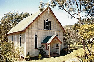
St Patrick's Catholic Church is a heritage-listed church at 1 Penda Street, Yungaburra, Tablelands Region, Queensland, Australia. It was built from 1914 to 1930s. It is also known as Our Lady of Ransom. The church is part of the Roman Catholic Diocese of Cairns. It was added to the Queensland Heritage Register on 21 October 1992.


