Samara, known from 1935 to 1991 as Kuybyshev, is the largest city and administrative centre of Samara Oblast in Russia.
Contents

Samara, known from 1935 to 1991 as Kuybyshev, is the largest city and administrative centre of Samara Oblast in Russia.
In Western European Sources information of Central Asia in the third quarter of the 12th Century is unknown. Information of Central Asia appears in Europe in connection with the legendary figure of Prester John, which dates from 1165. [1] [ circular reference ]
One of the earliest document where the toponym is mentioned is the Chronicle by Hugh of Saint Victor, one of the founders of the 12th century Saint Victorian school of theology. He established the chronicle named the Description of World Map, in which the most important cities and settlements were shown. [2] [ circular reference ]
In the Book of Extractions by Richard of Saint Victor, which dates from 1153 to 1162, it mentioned Samara. Samara among other Scythian cities is located beyond the Caucasian mountains in the northeast.
On the Christianization of the ruling elite of the Khazar Kaganate in the 8th century, archeological investigations in the region of the “country” Belendzher in the Caucasus testify . Later, under the onslaught of the Arab troops, the Khazars will move to the north, there will be a massive subsidence on the ground, resulting in a so-called Saltov-Mayak culture, which currently rests at the bottom of the Sulak Hydroelectric Power Plant . Note that such “mini-Atlantis” on the site of the Khazar urban centers were formed on the territory of the USSR due to the creation of reservoir systems . The funerary complex around Chir-Yurt belongs to three ethnic groups that inhabited the city: Alans ( catacomb burials ), Bulgarians( pit burials ), Khazars (kurkan catacombs). In the kurgan section of the cemetery where the Khazars rested, scientists discovered two small churches of the 8th century, which is a clear indication of the Christianization of the ruling elite of the Kaganate before its Judaization at the turn of the 8th — 9th centuries. On the Middle Volga in the steppe valleys of the Samara Luka in the beginning of the 21st century, several burial grounds with sub-burial burials of the turn of the 7th — 8th centuries were investigated, which are similar to the kurgan burials of the Lower Volga and the Don. For example, in one rich burial were found overlays from onions of “Khazar type”. The presence of the Khazars is marked far to the north of the Samara Luka. In the cemetery with a Shilovka (about 100 km to the north along the Volga), in a rich burial, in addition to the golden Byzantine solidarity of the 7th century, there were also bone plates with hunting scenes, images of soldiers on the fortress wall, etc. Experts believe that the patterns on the bone plates are close to the images on silver dishes, which were made in one of the Khazar jewelry workshops [3] [ circular reference ].
In addition to the legend relating to the “Kasr” (from the Arabic. “Castle”) Samara, the artists edged the miniature of the city with rivers. At the source of the river Samara (Samur ), which flows into the Volga, the artist placed the image of the only tree on the whole map. From the bottom of the tree flows eastward stream. Near the "miracle tree" comment: "Here is a tree from which water flows" (perhaps, we are talking about the tree Betula alba (pendula) - birch and birch sap). The source of this legend we find in the report of Ibn Fadlan, who is part of the embassy of the Abbasid Caliph al-Muqtadir(908–932) visited Volga Bulgaria in May 922. It can be assumed that this information came to the West from the Arab-Persian world or through Byzantium, or through Sicily, during the reign of Emperor Frederick II of Hohenstaufen (1194–1250).
If we talk about the archaeological evidence of the times of the Golden Horde, then in the Samara area there are two settlement sites that relate to this era: one is 20 km below the settlement of Singiley; another in front of Samara near the village Perevolok . As early as the 19th century, ruins of brick and stone buildings visible above the ground were observed in the area of fortifications, silver and copper coins were encountered, but systematic archaeological research was not conducted there [9] .
On the 1448 plan-plan of the Benedictine monk from the monastery of St. Peter [en] in Salzburg ( lat. Ordinis Sancti Benedicti de Salisburg ) Andreas Walchperger [en] (born around 1415) on a large river in Eastern Europe is present the toponym “Samarchar” .
Fortified castle, located on the left bank of Edil (Volga) on the 1459 world map, Fra Mauro is called Samar ( Latin Samar ). Samar (a), surrounded by high fortress towers with battlements, between which there are passage gates, is located at the confluence of the “blue river” ( Italian fl [umen] coche su ) into the Volga. The name suggests that the waters of the river Samara in the Middle Ages were distinguished by purity and transparency. On this wonderful map of the world, based on the best graphic and written sources available to its creators, you can immediately place accents about the unlawful identification of Samara and Samarkand in foreign historiography for a long time - a legend placed near the city of Samarkand reads: “The Samarkand Kingdom . This Kingdom of Samarkand was ruled by Tamerlane ... This glorious city [Samarkand] was decorated with beautiful nobility by the most beautiful buildings, among which the castle was particularly notable for its size and power. The governor of this state was exclusively of that kind from which Tamerlan himself descended ”.
Al-Masudi's narrative about the adoption of Judaism in the Khazars during the reign of Kharuna al-Rushūda was based on an even earlier essay, now lost. There are two fragments, which are based on the protograph that has not come down to us. They were incorporated into the composition of the Arab cosmographer Shams ad-dun Muhammad ibn abỹ Tqlib ad-Dimashk (1256–1327). It says that at the time of Huruna ar-Rashūda the emperor of the Romans (apparently, it was Nikifor I (ruled in 802–811, since 803, together with his son Stavraki ), expelled the Jews from Byzantium. They moved to Khazaria,“Where they found intelligent and pious people, declared their faith to them, and they recognized it as the most correct, joined it, remaining [in this faith] for a while. Then the army fought with them from Khorasan, captured their cities, their country, they [the Khazars] became [their] subjects. Says Ibn al-Athir [an Arab historian who lived in 1160 - 1234 - approx. auth.] also that they converted to Islam in 254 [ on Hijra, i.e. in 868 - approx. auth.]; He points out that the cause of their acceptance of Islam was the military attack of the Turks. So they [the Khazars] asked for help from the people of Khorezm, and they answered: “You are the infidels, accept Islam, and we will help you.” They accepted Islam, except for their king, and the Khorezmians helped them, and the Turks withdrew from them. After that, they accepted Islam and their king.
We also cite information from the essay "News of Khozars, Burtas, Bulgarians ..." by an Arab geographer of the early 10th century. Abu 'Alū Ahmed Ibn' Omar, Ibn Ruste (Ibn Dusta), when the top of the Khazar state already accepted Judaism, i.e. roughly from 802/803 to 869/870 :“They call their king Isha [Beck - approx. auth.]; their sovereign, Khozar-Hakan. But this last only by the name of the sovereign, the real power belongs to Isha, since he is in a position of this kind with respect to the affairs of command and control of the troops, which gives no account to anyone who would stand above him. The supreme head of them professes the Hebrew faith; of the same faith as Isha, so are the captains and nobles who are with him; the rest of the Khozars profess a religion similar to that of the Turks ” .
The foundation of the Samara small town in the Samara natural boundary occurred in 1586 by decree of Tsar Fyodor Ivanovich on the bank of the Samara River near its confluence with the Volga under the direction of Prince G. O. Zasekinand the Streletsky heads of the “comrade” (deputy governor) Yelchaninov and Streshnev. The purpose of the fortress is the protection of shipping on the Middle Volga and the protection of state frontiers from raids by the steppe
The fortress was built on the territory now occupied by the Samara valve factory, and to the south of it - that is, in the direction of the r. Samara. It was built from May 22 to August 19. Art. (May 9 - August 6, Art. Art.) 1586. The first inhabitants were the serving people: the boyars' children, archers, gunners and collars, who carried the guard service, guarding the new fortress “from thieves” and from the Nogai attacks .
The fortress has not survived to this day (it burned down in the fires of 1690 and 1703), however, it was possible to restore its exact dimensions (perimeter 635 m) and location. The Samara fortress of 1586 was a fortification of two parallel log walls, which every 6–8 m were joined by transversal walls cut at them at a right angle. The space between the walls (its width could be different, reaching 3 m) was filled with earth and stones. The total thickness of such a fortress wall was about 5 m. The height of the Samara city wall is not known from the documents, but, following the height of the wall in the Volga cities, we can assume that it varied in different areas from 4.5 to 6 m. Samara Fortress had 8 towers, of which 4 were passable, that is, had a gate. The fortress towers are structures with hipped roofs, in terms of square, quadrangular or (at the corners) polygonal, with sides from 4 to 14 m long, usually 8–10 m high, with single towers about 6 m high or vice versa up to 15 m. The tower protruded 2–3 m outside the walls of the fortress. Inside the tower, three tiers ('battles') were equipped inside, each of which housed guns. Some towers did not have a hip roof, but all had clouds (or breaks) - an extended and overhanging upper part, due to which a vertical slot formed between the upper and lower layers of the walls for firing from above to the besiegers. The distance between adjacent towers varied, sometimes differing by half. Service on the tower was carried by a guard from one representative of the "boyars' children" appointed by the voivode and armed archers sent by the archer's head (for example, Kazan, usually 4 archers for each tower) usually 8–10 m high with single towers about 6 m high or vice versa up to 15 m.
Probably already in 1587 (in any case, not later than the beginning of the 1590s), the Samara fortress (or the city, or the Kremlin ) was surrounded on 3 sides by a second defensive line - a wall of guard type (1542 m long). Ostrog (more rarely, palisade ) is, in fact, a high fence of vertically standing log-piles with a diameter of 25–30 cm vertically standing close to each other. The height of the wall was 4-4.5 m (according to Laishev, Malmyzh and other fortresses of the Volga region). Samara fortress had 8 towers (probably four-walled [24]), and some of them were also passing. The combination of fortress and fort is typical of Russian defense town planning of the 16th — 17th centuries. They are interrelated parts of a single defensive complex, the general plan for the construction of which, apparently, already existed in 1586.
The topography of the Samara fortress in 1586, the fort, the first cathedral churches of Samara and the church of the first Samara monastery are presented for reconstruction.
The first image of Samara is widely known in the description and in the engraving by A. Olearius. The Holstein embassy of 1636 sailed past Samara "even before the rising of the Sun" and made only a brief stop, after which "they dismissed the sails and set off further." The channel of the Volga at that period was 2 versts from Samara (= 2.1 km). That is, the city of A. Olearius observed from afar and under unfavorable light conditions - in the predawn twilight or in the blinding rays of the rising sun in the east. Therefore, it is not necessary to rely on the accuracy of the transfer of A. Olearius to the location of churches and other details. But even in such conditions, the engraving correctly shows the number of towers and churches (except for the southern part of the fortress, which is the farthest from the observer, the worst part of the fortress), a cautious type of wall on the Volga coast is realistically reflected.
During the XVII century the city grew and continued to strengthen. By the beginning of 1700, the fortification of Samara included five lines of wooden fortifications: a fortress (the Kremlin), a fortress (two lines), and ancholes (also two lines, but dilapidated or collapsed). After the devastating fires of 1700 and 1703, a new fortress (the so-called "earthen") of 1704-1706 was built in the city. Its remains were discovered during the archaeological excavations of 2013–2014 on Khlebnaya Square.
In the spring of 1646, the first household census of Samara was carried out with the suburb, the only settlement at that moment - Boldyrskaya - and the county (there is information about the early formation of the nobility around the city of Samara, and previous censuses). Thus, the fortress of Samara had all the rights of the city since its foundation in 1586.
In 1708 Samara - the ninth city of Kazan Province. Since 1719, Samara belongs to the Astrakhan province . Since 1728 Samara once again belongs to the Kazan province . Since 1780, Samara belongs to Simbirsk governorship . Since 1796, Samara belongs to Simbirsk province . In 1851, Samara - the provincial capital and the capital of the Samara province, numbering 15 thousand people. Since then, the city began to flourish; She was known as the "Russian Chicago" due to giant mills, numerous small factory, barns. In the city there were 375 trade shops, and the Samara province was the leader in the number of wheat collected in the Russian Empire . Since 1928, Samara becomes the center of the Middle Volga region . Since 1929, Samara is the center of the Middle Volga region . In 1935, Samara was renamed Kuibyshev, part of the Kuibyshev region . Since 1936, Kuibyshev (Samara) is the center of the Kuibyshev region . In 1990, Samara returned the historical name, the city is the center of the Samara Oblast.
On June 8, 1918, deputies of the All-Russian Constituent Assembly formed in Samara a government independent of the Bolshevik government. It was called the Committee of Members of the Constituent Assembly (Komuch). The chairman was Vladimir Volsky, a deputy from the Socialist Revolutionary Party.
In 1935, Samara was renamed Kuibyshev.
During the Great Patriotic War, Samara (then Kuibyshev) was actually the second capital of the USSR: the Government, diplomatic missions and many enterprises evacuated from the western regions (located mainly on Bezymyanka ) were located here. The level of industrial production increased 5.5 times by 1945 compared with 1940. For the Supreme Commander Stalin, a spare residence was built, now known as the Stalin Bunker, and available for visiting by excursion groups. The Bolshoi Theater worked in evacuation in Kuibyshev; here the seventh Leningrad symphony by D. D. Shostakovich was written and first performed .
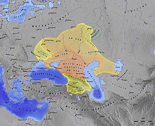
The Khazars were a nomadic Turkic people that, in the late 6th-century CE, established a major commercial empire covering the southeastern section of modern European Russia, southern Ukraine, Crimea, and Kazakhstan. They created what for its duration was the most powerful polity to emerge from the break-up of the Western Turkic Khaganate. Astride a major artery of commerce between Eastern Europe and Southwestern Asia, Khazaria became one of the foremost trading empires of the early medieval world, commanding the western marches of the Silk Road and playing a key commercial role as a crossroad between China, the Middle East and Kievan Rus'. For some three centuries the Khazars dominated the vast area extending from the Volga-Don steppes to the eastern Crimea and the northern Caucasus.
Sarkel was a large limestone-and-brick fortress in what is now Rostov Oblast of Russia, on the left bank of the lower Don River.
Year 737 (DCCXXXVII) was a common year starting on Tuesday of the Julian calendar. The denomination 737 for this year has been used since the early medieval period, when the Anno Domini calendar era became the prevalent method in Europe for naming.
Atil, also Itil, was the capital of the Khazar Khaganate from the mid-8th century to the late 10th century. Known to have been situated on the Silk Road, in the vicinity of the Caspian Sea, its precise location has long been unknown.

Samarkand or Samarqand is a city in southeastern Uzbekistan and among the oldest continuously inhabited cities in Central Asia. Samarkand is the capital of Samarqand Region and a district-level city, that includes the urban-type settlements Kimyogarlar, Farhod and Khishrav. With 551,700 inhabitants (2021), it is the third-largest city of Uzbekistan.

The Volga is the longest river in Europe. Situated in Russia, it flows through Central Russia to Southern Russia and into the Caspian Sea. The Volga has a length of 3,531 km (2,194 mi), and a catchment area of 1,360,000 km2 (530,000 sq mi). It is also Europe's largest river in terms of average discharge at delta – between 8,000 m3/s (280,000 cu ft/s) and 8,500 m3/s (300,000 cu ft/s) – and of drainage basin. It is widely regarded as the national river of Russia. The hypothetical old Russian state, the Rus' Khaganate, arose along the Volga c. 830 AD. Historically, the river served as an important meeting place of various Eurasian civilizations.

Samara, formerly known as Kuybyshev during Soviet rule, is the largest city and administrative centre of Samara Oblast in Russia. The city is located at the confluence of the Volga and the Samara rivers, with a population of over 1.14 million residents, up to 1.22 million residents in the urban agglomeration, not including Novokuybyshevsk, which is not conurbated. The city covers an area of 541.382 square kilometers (209.029 sq mi), and is the eighth-largest city in Russia and tenth agglomeration, the third-most populous city on the Volga, as well as the Volga Federal District.

Bukhara is the seventh-largest city in Uzbekistan by population, with 280,187 residents as of 1 January 2020. It is the capital of Bukhara Region.
Ahmad ibn Fadlan ibn al-Abbas al-Baghdadi was a 10th-century traveler from Baghdad, Abbasid Caliphate, famous for his account of his travels as a member of an embassy of the Abbasid caliph, al-Muqtadir of Baghdad, to the king of the Volga Bulgars, known as his risāla.

Volga Bulgaria or Volga–Kama Bulgaria was a historical Bulgar state that existed between the 9th and 13th centuries around the confluence of the Volga and Kama River, in what is now European Russia. Volga Bulgaria was a multi-ethnic state with large numbers of Bulgars, Finno-Ugrians, Varangians, and East Slavs. Its strategic position allowed it to create a local trade monopoly with Norse, Cumans, and Pannonian Avars.

Derbent, formerly romanized as Derbend, is a city in Dagestan, Russia, located on the Caspian Sea. It is the southernmost city in Russia, and it is the second-most important city of Dagestan. Derbent occupies the narrow gateway between the Caspian Sea and the Caucasus Mountains connecting the Eurasian Steppe to the north and the Iranian Plateau to the south; covering an area of 69.63 square kilometres (26.88 sq mi), with a population of roughly 120,000 residents.
ʿAbd al-Raḥmān ibn Rabīʿa al-Bāhilī was an Arab general of the Rashidun Caliphate, who led the Arab forces during the First Arab–Khazar War, until his death in battle in 652.
The Battle of Balanjar took place during the First Khazar-Arab War between the armies of the Khazar Khaganate and the Caliphate, whose commanding general was Abd ar-Rahman ibn Rabiah.
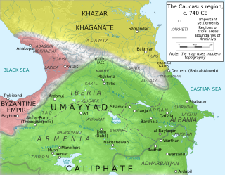
The Arab–Khazar wars were a series of conflicts fought between the Khazar Khaganate and successive Arab caliphates in the Caucasus region from c. 642 to 799 CE. Smaller native principalities were also involved in the conflict as vassals of the two empires. Historians usually distinguish two major periods of conflict, the First Arab–Khazar War and Second Arab–Khazar War ; the wars also involved sporadic raids and isolated clashes from the mid-seventh century to the end of the eighth century.

The Caspian expeditions of the Rus' were military raids undertaken by the Rus' between the late 9th century and c. 1041 on the Caspian Sea shores, of what are nowadays Iran, Dagestan, and Azerbaijan. Initially, the Rus' appeared in Serkland in the 9th century travelling as merchants along the Volga trade route, selling furs, honey, and slaves. The first small-scale Viking raids took place in the late 9th and early 10th century. The Rus' undertook the first large-scale expedition in 913; having arrived on 500 ships, they pillaged in the Gorgan region, in the territory of present-day Iran, and more to the west, in Gilan and Mazandaran, taking slaves and goods. On their return, the northern raiders were attacked and defeated by the Khazars in the Volga Delta, and those who escaped were killed by the local tribes in the middle Volga.
In the Middle Ages, the Volga trade route connected Northern Europe and Northwestern Russia with the Caspian Sea and the Sasanian Empire, via the Volga River. The Rus used this route to trade with Muslim countries on the southern shores of the Caspian Sea, sometimes penetrating as far as Baghdad. The powerful Volga Bulgars formed a seminomadic confederation and traded through the Volga river with Viking people of Rus' and Scandinavia and with the southern Byzantine Empire Furthermore, Volga Bulgaria, with its two cities Bulgar and Suvar east of what is today Moscow, traded with Russians and the fur-selling Ugrians. Chess was introduced to Medieval Rus via the Caspian-Volga trade routes from Persia and Arabia.

The Battle of the Defile or Battle of the Pass was fought in the Takhtakaracha Pass between a large army of the Umayyad Caliphate and the Turkic Türgesh khaganate over three days in July 731 CE. The Türgesh had been besieging Samarkand, and Samarkand's commander, Sawra ibn al-Hurr al-Abani, had sent a request for relief to the newly appointed governor of Khurasan, Junayd ibn Abd al-Rahman al-Murri. Junayd's 28,000-strong army was attacked by the Türgesh in the pass, and although the Umayyad army managed to extricate itself and reach Samarkand, it suffered enormous casualties; Sawra's 12,000 men, who had been commanded to attack the Türgesh from the rear in a relief effort, were almost annihilated.

Dashtadem Fortress (Qagheni fortress) is a substantial fortress of the 5th to 19th centuries located at the southern outskirts of Dashtadem village in the Aragatsotn Province of Armenia. In a cemetery 1.7 km (1.1 mi) south of Dashtadem, lies the restored 7th-century Kristapori Vank which may be viewed in the distance from the Qagheni fortress.
The following is a timeline of the history of the city of Samara, Russia.
Semikarakorsk Fortress was an early medieval Khazar fortification situated near the city of Semikarakorsk.