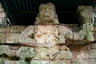
Copán is an archaeological site of the Maya civilization in the Copán Department of western Honduras, not far from the border with Guatemala. This ancient Maya city mirrors the beauty of the physical landscape in which it flourished—a fertile, well-watered mountain valley in western Honduras at an elevation of 600 meters above mean sea level. It was the capital city of a major Classic period kingdom from the 5th to 9th centuries AD. The city was in the extreme southeast of the Mesoamerican cultural region, on the frontier with the Isthmo-Colombian cultural region, and was almost surrounded by non-Maya peoples.

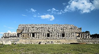
Uxmal is an ancient Maya city of the classical period located in present-day Mexico. It is considered one of the most important archaeological sites of Maya culture, along with Palenque, Chichen Itza and Calakmul in Mexico, Caracol and Xunantunich in Belize, and Tikal in Guatemala. It is located in the Puuc region of the western Yucatán Peninsula, and is considered one of the Maya cities most representative of the region's dominant architectural style. It has been designated a UNESCO World Heritage Site in recognition of its significance.

Izamal is a small city in the Mexican state of Yucatán, 72 kilometres (45 mi) east of state capital Mérida, in southern Mexico.

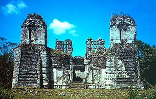
Zaculeu or Saqulew is a pre-Columbian Maya archaeological site in the highlands of western Guatemala, about 3.7 kilometres (2.3 mi) outside the modern city of Huehuetenango. Occupation at the site dates to the Early Classic period (AD 250–600) of Mesoamerican history. Zaculeu was the capital of the Postclassic Mam kingdom, and was conquered by the Kʼicheʼ Kingdom of Qʼumarkaj. It displays a mixture of Mam and Kʼicheʼ style architecture.
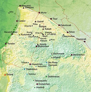
Puuc is the name of either a region in the Mexican state of Yucatán or a Maya architectural style prevalent in that region. The word puuc is derived from the Maya term for "hill". Since the Yucatán is relatively flat, this term was extended to encompass the large karstic range of hills in the southern portion of the state, hence, the terms Puuc region or Puuc hills. The Puuc hills extend into northern Campeche and western Quintana Roo.
Kabah is a Maya archaeological site in the Puuc region of western Yucatan, south of Mérida.
Mixco Viejo, occasionally spelt Mixcu Viejo, is an archaeological site in the north east of the Chimaltenango department of Guatemala, some 50 kilometres (31 mi) to the north of Guatemala City and 4 kilometres (2.5 mi) from the junction of the rivers Pixcaya and Motagua. It is a moderate sized ruined city of the Postclassic Maya civilization.
Río Bec is a pre-Columbian Maya archaeological site located in what is now southern portion of the Mexican state of Campeche. The name also refers to an architectural style that first appeared at Río Bec and subsequently spread to other nearby sites. The Río Bec Style is closely related to the Chenes architectural style found northwest of the Río Bec region.

Maya architecture spans several thousands of years, several eras of political change, and architectural innovation before the Spanish colonization of the Americas. Often, the buildings most dramatic and easily recognizable as creations of the Maya peoples are the step pyramids of the Terminal Preclassic Maya period and beyond. Based in general Mesoamerican architectural traditions, the Maya utilized geometric proportions and intricate carving to build everything from simple houses to ornate temples. This article focuses on the more well-known pre-classic and classic examples of Maya architecture. The temples like the ones at Palenque, Tikal, and Uxmal represent a zenith of Maya art and architecture. Through the observation of numerous elements and stylistic distinctions, remnants of Maya architecture have become an important key to understanding their religious beliefs and culture as a whole.
Ancient Maya art is the visual arts of the Maya civilization, an eastern and south-eastern Mesoamerican culture made up of a great number of small kingdoms in present-day Mexico, Guatemala, Belize and Honduras. Many regional artistic traditions existed side by side, usually coinciding with the changing boundaries of Maya polities. This civilization took shape in the course of the later Preclassic Period, when the first cities and monumental architecture started to develop and the hieroglyphic script came into being. Its greatest artistic flowering occurred during the seven centuries of the Classic Period.

The Pyramid of the Magician is a Mesoamerican step pyramid located in the ancient Mayan city of Uxmal, Mexico. It is the tallest and most recognizable structure in Uxmal.

Yaxha is a Mesoamerican archaeological site in the northeast of the Petén Basin region, and a former ceremonial centre and city of the pre-Columbian Maya civilization. Yaxha was the third largest city in the region and experienced its maximum power during the Early Classic period.

Xtampak is a Maya archaeological site in the Mexican state of Campeche. A major town in the Chenes region, it flourished during the Late Classic era.

Chicanná was a Maya town that was built during the Classic period. The site was named after its most famous building, Structure II, which means "House of the Serpent Mouth" in Mayan. In the Mayan language chi means "mouth", can means "serpent" and na means "house". The site is located two kilometers west of Becán in the Mexican state of Campeche on the Yucatán peninsula. It is one of 45 other ruin sites located within that area.

Chichén Itzá was a large pre-Columbian city built by the Maya people of the Terminal Classic period. The archeological site is located in Tinúm Municipality, Yucatán State, Mexico.
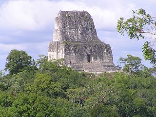
Tikal Temple IV is a Mesoamerican pyramid in the ruins of the ancient Maya city of Tikal in modern Guatemala. It was one of the tallest and most voluminous buildings in the Maya world. The pyramid was built around 741 AD. Temple IV is located at the western edge of the site core. Two causeways meet at the temple; the Tozzer Causeway runs east to the Great Plaza, while the Maudslay Causeway runs northeast to the Northern Zone. Temple IV is the second tallest pre-Columbian structure still standing in the New World, just after the Great Pyramid of Toniná in Chiapas, Mexico, although Teotihuacan's Pyramid of the Sun may once have been taller.

The Plaza of the Seven Temples is an architectural complex in the ruins of the Maya city of Tikal, in the Petén Department of northern Guatemala. It is to the south of Temple III and to the west of the South Acropolis; it is 300 metres (980 ft) to the southwest of the Great Plaza. The Plaza of the Seven Temples is situated directly to the east of the Mundo Perdido Complex and takes its name from a row of seven small temples dating to the Late Classic Period. The plaza has a surface area of approximately 25,000 square metres (270,000 sq ft), making it one of the three largest plazas in the city.

The Mundo Perdido is the largest ceremonial complex dating from the Preclassic period at the ancient Maya city of Tikal, in the Petén Department of northern Guatemala. The complex was organised as a large E-Group astronomical complex consisting of a pyramid aligned with a platform to the east that supported three temples. The Mundo Perdido complex was rebuilt many times over the course of its history. By AD 250–300 its architectural style was influenced by the great metropolis of Teotihuacan in the Valley of Mexico, including the use of the talud-tablero form. During the Early Classic period the Mundo Perdido became one of the twin foci of the city, the other being the North Acropolis. From AD 250 to 378 it may have served as the royal necropolis. The Mundo Perdido complex was given its name by the archaeologists of the University of Pennsylvania.
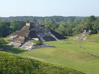
Comalcalco is an ancient Maya archaeological site in the State of Tabasco, Mexico, adjacent to the modern city of Comalcalco and near the southern coast of the Gulf of Mexico. It is the only major Maya city built with bricks rather than limestone masonry and was the westernmost city of the Maya civilisation. Covering an area of 7 km2 (2.7 sq mi), Comalcalco was founded in the Late Classic period and may have been a satellite or colony of Palenque based on architectural similarities between the two. The city was a center of the Chontal Maya people.

Kulubá is an ancient Maya civilization city and archeological site in Mexico. It is located in Tizimín Municipality, northeast Yucatan, Mexico. The site contains a palace, an altar, ruins of two residences, and a round structure believed to be an oven. The palace measures 6 metres (20 ft) tall, 55 metres (180 ft) long and 15 metres (49 ft) wide, and is believed to have been inhabited between 600-1050 CE.

