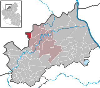
Ahrweiler is a district in the north of Rhineland-Palatinate, Germany. It is bounded by the districts of Euskirchen, Rhein-Sieg and the city of Bonn in the state of North Rhine-Westphalia, and the districts of Neuwied, Mayen-Koblenz and Vulkaneifel.

The Swist is a stream, 43.6 kilometres (27.1 mi) long, in the German Rhineland. It rises on the northern edge of the Eifel at 330 metres above sea level and empties rom the right and southeast into the Rhine tributary, the Erft, between Weilerswist and Bliesheim. Occasionally the Swist is also called the Swistbach, and locals often just call it der Bach.
The Voreifel is the name of a settlement area in the southern part of the German state of North Rhine-Westphalia. It is a term that grew out of the local speech.

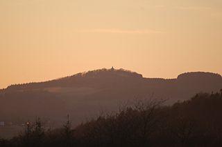
The Aremberg is, at 623 m above sea level (NN), the highest mountain in the Ahr Hills or Ahr Eifel (Ahreifel). It lies in the district of Ahrweiler, Rhineland-Palatinate (Germany).

The Ahr valley is named after the Ahr, a left tributary of the Rhine in Germany. It begins at the Ahr spring (Ahrquelle) in Blankenheim in the county of Euskirchen and runs generally eastwards. At its southernmost point it enters the county of Ahrweiler, and hence the state of Rhineland-Palatinate. Running through the collective municipality of Adenau the valley bends northeast at its confluence with the Adenauer Bach and reaches the collective municipality of Altenahr, from where it resumes its characteristic west to east course, albeit interrupted by meanders. Here begins the section that is known as the Ahr valley (Ahrtal) in a touristic sense. Here it is characterized by vineyards on the south-facing slopes and a picturesque rocky landscape, carved out by the river creating a 300 metre deep gorge in the Ahr Hills. In the next stage the Ahr reaches the area of the county town of Bad Neuenahr-Ahrweiler, before finally discharging into the Rhine south of Remagen in the borough of Sinzig.

The Heidenköpfe (plural) are a group of three summits near Dahlem in Germany that are about 595 m above sea level (NHN). They lie within the mountain region of North Eifel in the counties of Euskirchen and Vulkaneifel in the states of North Rhine-Westphalia (NW) and Rhineland-Palatinate (RP).
The Eigart is a hill located in the county of Euskirchen in the German state of North Rhine-Westphalia at 565.5 m above sea level (NN), in the North Eifel.

The Hochstein is a volcanic cone, 563 m above sea level (NHN), in the Eifel near Obermendig in the German state of Rhineland-Palatinate and county ofMayen-Koblenz.
Münstereifel Forest is densely wooded region in the northern part of the Eifel mountains in North Rhine-Westphalia, Germany. In the south it borders on the state of Rhineland-Palatinate. It has an area of 237 km² and lies at a height of between 200 and 500 m above sea level (NHN).
The Wildbretshügel, at 525.3 m above sea level (NHN), is the third highest hill in the Kermeter, an upland region which is part of the Northern Eifel. It is located near Gemünd and Hasenfeld in the counties of Euskirchen and Düren in the German state of North Rhine-Westphalia.

The Häuschen is a hill, 506.5 m above sea level (NHN), in the Eifel mountains. It rises near Ahrweiler in the county of Ahrweiler in the German state of Rhineland-Palatinate.

The Teufelsley is a hill, 495.9 m above sea level (NHN), in the East Eifel, a region of the Eifel mountains in Germany. It is located near Liers in the county of Ahrweiler in the state of Rhineland-Palatinate and consists of the largest contiguous quartzite block in Europe.
Odenbach is a village in the county of Kusel, Rhineland-Palatinate.
The Trödelsteine is the name of a mountain, 613 m above sea level (NHN), in the Heller Upland near Emmerzhausen in the county of Altenkirchen in the German state of Rhineland-Palatinate and in the county of Siegen-Wittgenstein in the state of North Rhine-Westphalia with its summit area in Rhineland-Palatinate.
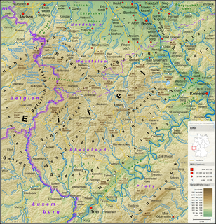
The Eifel dialects are those dialects spoken in the Eifel mountains of Germany. They divide into two language regions: the dialects spoken in the southern Eifel (Eifelisch) are part of the Moselle Franconian dialect group and closely resemble Luxembourgish. In the northern Eifel, by contrast, the dialects (Eifelplatt) belong to the Ripuarian dialect group and are more like Öcher Platt or Kölsch. In between there is a dialect continuum of typical transitions, whereby more or less every village speaks a little differently from its neighbours.