Related Research Articles
Division No. 1, Subdivision A is an unorganized subdivision on the Avalon Peninsula in Newfoundland and Labrador, Canada. It is in Division No. 1, and lies between Trinity Bay and Placentia Bay.
Baynes Sound is the channel between Denman Island and Vancouver Island, British Columbia, Canada. The sound is a narrow western offshoot of the Strait of Georgia that separates Vancouver Island from the mainland of British Columbia. The area is actively harvested by the local oyster industry, as is apparent by an abundance of oyster farms. It produces 39% of the oysters and 55% of the manila clams farmed in British Columbia. The sound is 40 km (25 mi) long and is 3.5 km (2.2 mi) wide at its widest point, although the average width is less than 2 km (1.2 mi). The southern boundary lies around Chrome Island, a small island off Boyle Point, the southern tip of Denman. The northern boundary is less defined, but lies between Tree Island at the northern end of Denman and the Comox harbour. The sound is dotted with the small communities of Royston, Union Bay, Buckley Bay, Mud Bay, Fanny Bay, and Deep Bay on Vancouver Island. The crossing is served by the British Columbia Ferry Services Inc. ship MV Baynes Sound Connector, between Buckley Bay and Denman Island. Baynes Sound is named after British Rear Admiral Robert L. Baynes, who commanded the Pacific Squadron from 1857 to 1860. Baynes Sound is the home of Vancouver Island University Center for Shellfish Research's Deep Bay Marine Field Station.

Esteribar is a town and municipality located in the province and autonomous community of Navarre, northern Spain. The municipal administrative centre is in Zubiri.
Burgoyne Bay Provincial Park is a provincial park in British Columbia, Canada located on southwestern Saltspring Island near Fulford Harbour. The parks faces northwest to Sansum Narrows, which is the channel between Saltspring Island and Vancouver Island. Mount Maxwell Provincial Park lies adjacent to the north.
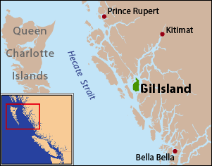
Gil Island is an island on the North Coast of British Columbia, Canada, located on the west side of Whale Channel in the entrance to Douglas Channel, one of the main coastal inlets, on the route of the Inside Passage between Pitt Island and Princess Royal Island. It is 26 km (16 mi) long, with a width ranging from 6 to 13 km, and an area of 231 km2. The only named summit on the mountainous island is Mount Gil, which faces the opening of Douglas Channel.

Route 237 is a bypass road linking Catalina, Trinity Bay with Newman's Cove, Bonavista Bay. It is refer to as Church Street despite lack of signage as St. Peter's Anglican Church is located on the highway in Catalina.

Route 236 is a bypass road linking Port Rexton, Trinity Bay with King's Cove and nearby towns on Bonavista Bay. It runs north–south across between the two towns.
The Kluskus First Nation is the band government of the Lhoosk’uz, a Dakelh people whose main reserve located on the Chilcotin Plateau 130 km west of the city of Quesnel, British Columbia, Canada. The First Nation is a member of the Carrier-Chilcotin Tribal Council, which includes both Tsilhqot'in and Carrier (Dakelh) communities.

The Lil'wat First Nation, a.k.a. the Lil'wat Nation or the Mount Currie Indian Band, is a First Nation band government located in the southern Coast Mountains region of the Interior of the Canadian province of British Columbia. It is a member of the Lillooet Tribal Council, which is the largest grouping of band governments of the St'at'imc or Stl'atl'imx people. Other St'at'imc governments include the smaller In-SHUCK-ch Nation on the lower Lillooet River to the southwest, and the independent N'quatqua First Nation at the near end of Anderson Lake from Mount Currie, which is the main reserve of the Lil'wat First Nation, and also one of the largest Indian reserves by population in Canada.
The Bonavista Peninsula is a large peninsula on the east coast of the island of Newfoundland in the Canadian province of Newfoundland and Labrador. It consists of 50 incorporated towns/unincorporated communities which have a population of 12,176 as of the 2016 Canadian Census. Bonavista is the largest population centre on the peninsula.

The Headland of Cape Pine is the point of land marking the boundary of Trepassey Bay on the Avalon Peninsula of the island of Newfoundland in the Canadian province of Newfoundland and Labrador.
Old Shop is a local service district and designated place in the Canadian province of Newfoundland and Labrador. It is on the western side of the Dildo Arm, at the southern end of Trinity Bay. It is northwest of South Dildo, across the Dildo Arm from Dildo proper.
Skagit Bay is a bay and strait located in the U.S. state of Washington. It is part of the Whidbey Island Basin of Puget Sound. The Skagit River empties into Skagit Bay. To the south, Skagit Bay connects with the rest of Puget Sound via Saratoga Passage and Possession Sound. The boundary between Saratoga Passage and Skagit Bay is between Polnell Point on Whidbey Island and Rocky Point on Camano Island. To the northwest, Skagit Bay connects to the Strait of Juan de Fuca via the narrow strait of Deception Pass. A third waterway, the Swinomish Channel, connects Skagit Bay with Padilla Bay to the north.
Horwood is a local service district and designated place in the Canadian province of Newfoundland and Labrador. It was formerly known as Dog Bay. It is located northeast of Lewisporte just off of Route 331. It was once the home of a bustling lumber company owned by the Horwood family. Dog Bay was renamed Horwood after the family name.
The Nazko First Nation is a First Nations government of the Dakelh people in the north-central Interior of British Columbia. Its reserves are located around the community of Nazko, British Columbia, which is 120 km west of Quesnel and southwest of Prince George.
The Hartley Bay Indian Band is also known as the Gitga'at First Nation or the Hartley Bay First Nation. The members of the Gitga'at First nation are often referred to as Gitka'a'ata. The population of Gitk’a’ata peoples living in Hartley Bay ranges from approximately 130-200 people. There are also about 400-500 Gitk’a’ata peoples living in Prince Rupert, British Columbia, Canada, a neighboring territory. The Gitk’a’ata people have lived in Hartley Bay for hundreds of years, if not always. Some notable things regarding the Gitga'at First Nation are their economy, geography, government, sports involvement, COVID-19 regulations, and relations.
Antler Township is a civil township in Bottineau County in the U.S. state of North Dakota. As of the 2000 census, its population was 78. It is the only town in North Dakota to border both Saskatchewan and Manitoba.
The Buckley Bay station is a former inter-city rail stop located in Buckley Bay, British Columbia across the island highway from the Denman Island ferry, between Bowser and Union Bay. The station was a stop on Via Rail's Dayliner service. Service ended in 2011 due to poor track conditions along the line.
Ikertooq Fjord is a 55 km (34 mi) long fjord in the Qeqqata municipality in western Greenland. The fjord empties into Davis Strait 21 km (13 mi) south of Sisimiut.
Wild Bay is a natural bay on the coast of Labrador in the province of Newfoundland and Labrador, Canada. It lies within the southern reaches of Bonavista Bay, adjoining Monk Bay to the south.
References
- ↑ "Hodderville, NL, Canada". Google Maps. Google, Inc. Retrieved 30 April 2022.
48°32′00″N53°18′00″W / 48.53333°N 53.30000°W
| | This Newfoundland and Labrador location article is a stub. You can help Wikipedia by expanding it. |
| | This Canadian ghost town-related article is a stub. You can help Wikipedia by expanding it. |