Related Research Articles
Hant's Harbour is an incorporated town located on the east side of Trinity Bay on the Bay de Verde Peninsula in the province of Newfoundland and Labrador, Canada. It has a population of 318 according to the 2021 Canadian census.
Barachois Brook is a local service district and designated place in the Canadian province of Newfoundland and Labrador. It is on the western coast of the province, on Bay St. George, located just 5 km south of Stephenville Crossing.
Port Rexton is a small town in the Canadian province of Newfoundland and Labrador. It is located on the East Coast of the island of Newfoundland at the north end of Robinhood Bay, about 10 minutes east of Trinity and 3 hours north of St. John's. The town had a population of 690 in 1940, 449 in 1951, 454 in 1956, 351 in the Canada 2006 Census, 338 in the Canada 2011 Census and most recently 340 in the Canada 2016 Census. The town is part of a group of communities known as the Trinity Bight. The town is home to a few small businesses, including inns and restaurants as well as the Skerwink trail which connects Port Rexton to Trinity Harbour.

Salvage is a town located on the Eastport Peninsula of the Canadian province of Newfoundland and Labrador. The town had a population of 108 in the Canada 2021 Census.
Trinity Bay North is a town in the Canadian province of Newfoundland and Labrador. It is located at the northern tip of Trinity Bay. The town had a population of 1,649 in the Canada 2021 Census.
Port au Port Bay located on the west coast of the Island of Newfoundland formed by a long narrow point of land of the Port au Port Peninsula and the area of Newfoundland known as the Lewis Hills, in the Canadian province of Newfoundland and Labrador.
Hodderville was a settlement adjoining the small promonotory making the junction of Wild Bay and Monk Bay, which lie within Bonavista Bay west of Catalina. The town was named after the first Postmistress Mrs. Edith Hodder.
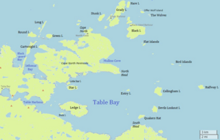
Table Bay is a natural bay and former community on the coast of Labrador in the province of Newfoundland and Labrador, Canada. It drains into the Labrador Sea to the east.
Isthmus Bay is a natural bay on the island of Newfoundland in the province of Newfoundland and Labrador, Canada. It is a sub-bay of St. George's Bay and flanked by the town of Port-au-Port. It is separated from Port au Port Bay by two narrow gravel isthmi.
Lockers Bay is a natural bay off the island of Newfoundland in the province of Newfoundland and Labrador, Canada.
Damnable Bay is a natural bay off the island of Newfoundland in the province of Newfoundland and Labrador, Canada.
Goose Bay is a natural bay off the island of Newfoundland in the province of Newfoundland and Labrador, Canada.
Blackhead Bay is a natural bay off the island of Newfoundland in the province of Newfoundland and Labrador, Canada. It is a side bay of Bonavista Bay.
Robinhood Bay is a natural bay off the island of Newfoundland in the province of Newfoundland and Labrador, Canada. It cuts into the southern shore of Bonavista Peninsula and opens into Trinity Bay. The town of Port Rexton is situated at the north end of the bay.
Partridge Bay is a natural bay on the coast of Labrador in the province of Newfoundland and Labrador, Canada. It lies to the north of Rocky Bay and to the south of Shoal Bay, with several small uninhabited islands across its entrance from the Labrador Sea.
Muddy Bay is a bay on the coast of Labrador in the province of Newfoundland and Labrador, Canada. It is a small eastern inlet of Favorite Tickle, a strait connecting Sandwich Bay in the south with the Atlantic Ocean in the north. The bay has a maximum depth between 18 and 20 meters.
Sandwich Bay is a natural bay on the coast of Labrador in the province of Newfoundland and Labrador, Canada. The principal permanent settlement is Cartwright, located at the south entrance to the inner part of the bay. Other settlements along the bay include Paradise River and North River. Both of these communities are located at the outlets of the rivers of the same name into the bay. There is a road following the entire eastern coastline of Sandwich Bay, Newfoundland and Labrador Route 516.
Bay St. George South is a local service district and designated place in the Canadian province of Newfoundland and Labrador on the south coast of Bay St. George, a large bay on the west coast of the island of Newfoundland. Bay St. George South consists nine communities, namely Heatherton, Robinsons, Cartyville, McKay's, Jeffrey's, St. David's, St. Fintan's, Lock Leven en Highlands.

Division No. 1, Subdivision G is an unorganized subdivision on the Avalon Peninsula in Newfoundland and Labrador, Canada. It is in Division 1 and contains the unincorporated communities of Baccalieu Island, Besom Cove, Bradley's Cove, Burnt Point, Caplin Cove, Daniel's Cove, Grates Cove, Gull Island, Job's Cove, Kingston, Long Beach, Lower Island Cove, Low Point, Northern Bay, Ochre Pit Cove, Red Head Cove, Riverhead, Smooth Cove and Western Bay.
Wild Cove is a local service district and designated place in the Canadian province of Newfoundland and Labrador. It is on the Baie Verte Peninsula of the island of Newfoundland.
References
- ↑ United States Hydrographic Office; Davenport, Richard G. (1884). Newfoundland and Labrador: The coast and banks of Newfoundland and the coast of Labador, from Grand Point to the Koksoak River, with the adjacent islands and banks (Public domain ed.). Govt. print. off. pp. 507–. Retrieved 20 November 2011.
- ↑ "Hodderville, NL, Canada". Google Maps. Google, Inc. Retrieved 30 April 2022.
48°31′57″N53°17′44″W / 48.5326°N 53.2955°W
| | This Labrador location article is a stub. You can help Wikipedia by expanding it. |