Hoek van Holland Strand railway station

Last updated
Hoek van Holland Strand
HvH station Strand2.jpg
General information
Location Hook of Holland
Netherlands
Coordinates 51°58′58″N4°7′10″E / 51.98278°N 4.11944°E / 51.98278; 4.11944
Operated by Nederlandse Spoorwegen
Line(s) Schiedam–Hoek van Holland railway
Platforms2
Other information
Station codeHlds
History
Opened1893
Closed1 April 2017 (end of NS service)
Services
Preceding station Nederlandse spoorwegen logo.svg Nederlandse Spoorwegen Following station
Terminus NS Sprinter 4000 Hoek van Holland Haven
Location
Randstad ZW.png
Red pog.svg
Hoek van Holland Strand
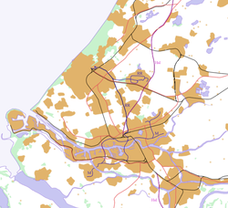
Location within Southwest Randstad
Netherlands location map.svg
Red pog.svg
Hoek van Holland Strand
Hoek van Holland Strand (Netherlands)

Hoek van Holland Strand station was the terminus of the Hoekse Lijn until 1 April 2017.

Contents

Hoek van Holland Strand. Sprinter nr. 2873 waits for departure to Rotterdam Central; 16 June 1990 16.06.90 Hoek van Holland Strand 2873 (5933862615).jpg
Hoek van Holland Strand. Sprinter nr. 2873 waits for departure to Rotterdam Central; 16 June 1990

This railway station in Hoek van Holland was opened on 1 June 1893 . It was approximately 700 meters further west than Hoek van Holland Haven station, with limited trains running to the station outside the summer months. Due to the construction of the Maasvlakte in 1971, the coastline came to lie further out to sea than when the station was opened, so that afterwards the station was no longer close to the beach, but more than a kilometre (about a 15-minute walk) away. [1]
New metro station

On 1 April 2017, the Hoekse Lijn was taken over by the Rotterdam-The Hague Metropolitan Region and converted into a metro line that came into use on 30 September 2019. From 1 April 2017 to 31 March 2023 there was replacement bus transport to the Badweg near the beach of Hoek van Holland.

As part of the renovation of the Hoekse Lijn into a metro line, the old Hoek van Holland Strand station closed on 1 April 2017. On 31 March 2023, a new Hoek van Holland Strand metro station was opened near the beach, for which the track has been extended by 900 metres. [2]

Former freight lines

There were 2 more railway lines at this height; the " Strand line " and the Westlandsche Stoomtramweg Maatschappij (WSM) tram both came on standard gauge from or next to the dunes, both served for freight transport. The beach line connected to the NS tracks and crossed the WSM branch line, which ended approximately here. The WSM line disappeared in 1951, and is now partly a cycle path. The beach line disappeared in 1971. [3]  

Related Research Articles

<span class="mw-page-title-main">Hook of Holland</span> Village in South Holland, Netherlands

Hook of Holland is a coastal village in the southwestern corner of Holland, hence the name; hoek means "corner" and was the word in use before the word kaap – "cape", from the Spanish cabo – became Dutch. The English translation using Hook is a false cognate of the Dutch Hoek, but has become commonplace. It is located at the mouth of the New Waterway shipping canal into the North Sea. The village is administered as a district of the municipality of Rotterdam. Its district covers an area of 16.7 km2, of which 13.92 km2 is land. On 1 January 1999 it had an estimated population of 9,400.

<span class="mw-page-title-main">Almere</span> City and municipality in Flevoland, Netherlands

Almere is a planned city and municipality in the province of Flevoland, Netherlands across the IJmeer from Amsterdam.

<span class="mw-page-title-main">Essen, Belgium</span> Municipality in Flemish Community, Belgium


Essen is a town and municipality in the Belgian province of Antwerp, notable for being bordered by the Netherlands on three sides. As of September 2022, it has a population of 19,029 residents. The town belongs to both the electoral canton of Brecht and the judicial canton of Kapellen and is situated in the region of Noorderkempen.

<span class="mw-page-title-main">Hoofddorp</span> Town in North Holland, Netherlands

Hoofddorp is the main town of the municipality of Haarlemmermeer, in the province of North Holland, the Netherlands. In 2021, the population was 77,885. The town was founded in 1853, immediately after the Haarlemmermeer had been drained.

<span class="mw-page-title-main">Amsterdam Zuid station</span> Railway station in Amsterdam, Netherlands

Amsterdam Zuid is a railway station situated in the borough of Amsterdam-Zuid in Amsterdam, Netherlands. For a number of years, it was named Amsterdam Zuid WTC, in reference to the neighbouring World Trade Center Amsterdam. During 2006, in conjunction with the rapid development of the area surrounding the station, the station was enlarged and the reference to the WTC was formally dropped from the name.

<span class="mw-page-title-main">Amsterdam Centraal station</span> Railway station in the Netherlands

Amsterdam Centraal station is the largest railway station in Amsterdam, North Holland, the Netherlands. A major international railway hub, it is used by 192,000 passengers a day, making it the second busiest railway station in the country after Utrecht Centraal and the most visited Rijksmonument of the Netherlands.

<span class="mw-page-title-main">Rotterdam Metro</span> Rapid transit system in Rotterdam, Netherlands

The Rotterdam Metro is a rapid transit system operated in Rotterdam, Netherlands and surrounding municipalities by RET. The first line, called Noord – Zuidlijn opened in 1968 and ran from Centraal Station to Zuidplein, crossing the river Nieuwe Maas in a tunnel. It was the first metro system to open in the Netherlands. At the time it was also one of the shortest metro lines in the world with a length of only 5.9 km (3.7 mi).

<span class="mw-page-title-main">Hoek van Holland Haven metro station</span> Rapid transit facility in the Netherlands

Hoek van Holland Haven is a metro station on Line B of the Rotterdam Metro, in Hook of Holland, Rotterdam, South Holland. Trains connect with the Stena Line Dutchflyer boat service to Harwich International in England. Until 1 April 2017, it was a railway station served by Nederlandse Spoorwegen. On 30 September 2019, it reopened as the western terminus of RET Metro Line B., and in 2023 it was extended to the new Hoek van Holland Strand station with the platforms relocated to the northwest of the historical station-building, so that they are on the new section of the line.

<span class="mw-page-title-main">Tramlijn 5</span>

Tramlijn 5 is a tram line operating between Amsterdam and Amstelveen in the Netherlands. Operated by the municipal transport company GVB, the route normally runs between Van Hallstraat in Amsterdam and Stadshart in the neighbouring municipality of Amstelveen. Tram line 5 connects several important areas of the city, including the Zuidas financial district and Leidseplein, and also provides a rapid tram route south of Amsterdam Zuid station to Stadshart, Amstelveen's town centre.

<span class="mw-page-title-main">Trams in Amsterdam</span> Overview of the tram system of Amsterdam, Netherlands

The Amsterdam Tram is a tram network in Amsterdam, Netherlands. It dates back to 1875 and since 1943 has been operated by municipal public transport operator Gemeentelijk Vervoerbedrijf (GVB), which also runs the Amsterdam Metro and the city bus and ferry services. Amsterdam has the largest tram network in the Netherlands and one of the largest in Europe.

<span class="mw-page-title-main">Hoek van Holland Strand metro station</span> Metro station in Hoek van Holland, Netherlands

Hoek van Holland Strand metro station is a metro station in Hook of Holland, Netherlands. It consists of two tracks with side platforms. Its former site was the terminus of the Schiedam–Hoek van Holland railway to Rotterdam when it opened on 1 June 1893. Its name is derived from the nearby North Sea beach, strand being Dutch for “beach”.

<span class="mw-page-title-main">Maassluis Centrum metro station</span> Metro station in Maassluis, the Netherlands

Maassluis Centrum, formerly Maassluis, is a metro station in Maassluis, The Netherlands.

<span class="mw-page-title-main">Maassluis West metro station</span> Metro station in Maassluis, the Netherlands

Maassluis West is a metro station in Maassluis, Netherlands. Originally opened as a railway station, it is now part of Rotterdam Metro Line B.

<span class="mw-page-title-main">Vlaardingen West metro station</span> Metro station in Vlaardingen, the Netherlands

Vlaardingen West is a metro station in Vlaardingen, the Netherlands. Located on the Hoekse Lijn, it is served by RET Metro Line B at all times, and Line A during peak periods.

<span class="mw-page-title-main">Vlaardingen Centrum metro station</span> Metro station in Vlaardingen, the Netherlands

Vlaardingen Centrum is a metro station in Vlaardingen in the Netherlands. The station is located on the Schiedam–Hoek van Holland railway.

<span class="mw-page-title-main">Vlaardingen Oost metro station</span> Metro station in Vlaardingen, the Netherlands

Vlaardingen Oost is a metro station in Vlaardingen in the Netherlands. Located on the Hoekse Lijn, it is served by RET Metro Line B at all times, and Line A during peak periods.

<span class="mw-page-title-main">Schiedam Nieuwland metro station</span> Metro station in Schiedam, the Netherlands

Schiedam Nieuwland is a metro station in Schiedam in the Netherlands. Located on the Hoekse Lijn, it is served by RET Metro Line B at all times, and Line A during peak periods.

<span class="mw-page-title-main">Schiedam Centrum station</span> Metro and railway station in Schiedam, Netherlands

Schiedam Centrum is a railway station and metro station in Schiedam, just to the west of Rotterdam, Netherlands, on the railway line between The Hague and Rotterdam Centraal. Train services are operated by Nederlandse Spoorwegen, and metro, tram and bus services are operated by Rotterdamse Elektrische Tram.

The Schiedam–Hoek van Holland railway is a former railway line and current rapid transit line of the Rotterdam Metro between Schiedam and Hook of Holland along the Nieuwe Maas, in the west of the Netherlands. The line is also an important freight railway, it is 24 kilometres long.

<span class="mw-page-title-main">Maassluis Steendijkpolder metro station</span> Metro station in South Holland

Steendijkpolder is a metro station on Line B of the Rotterdam Metro located in Maassluis, South Holland. The station entered regular service on 30 September 2019. Whereas located on the former Hoekse Lijn, converted from a railway, this is the only station of the line which never was a railway station and was constructed in 2019, when the railway was converted into rapid transit. Steendijkpolder consists of a side platform for westbound services toward Hook of Holland, and an island platform used by eastbound services toward Nesselande.

References