

The Hoher Stein is a rock formation at the northeastern foot of the Bergkopf mountain, part of the Waldstein ridge in Germany's Fichtel Mountains.
The Hoher Stein is a rock formation at the northeastern foot of the Bergkopf mountain, part of the Waldstein ridge in Germany's Fichtel Mountains.
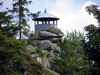
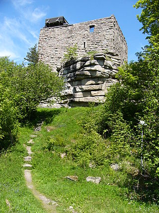
The Hoher Stein rocks are about 25 metres high, their highest point having an elevation of 817 m above NHN. They are granite rocks exhibiting spheroidal weathering. Iron ladders climb the rocks to a viewing point. The rocks are officially designated as climbing rocks.
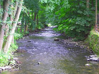
The Hoher Stein lies west of the town of Kirchenlamitz and northeast of the Großer Waldstein mountain in the forest district of Hallersteiner Forst Süd. Although the Hoher Stein is not far from another rock formation, the Kleiner Waldstein, they are only linked by circuitous routes. Sights in the vicinity are the source of the Lamitz and the Epprechtstein.
Today the rocks lie on the border between the Upper Franconian counties of Wunsiedel im Fichtelgebirge and Hof. In former times the political boundary between the districts of Sechsämterland and Landsmannschaft Hof ran here, something that goes back to the Landbuch der Sechsämter document of 1499 (see also Brandenburg-Kulmbach). The ecclesiastical boundary between the bishoprics of Bamberg and Regensburg also ran along the crest of the ridge.
The Hohenzollern coat of arms (32 cm wide, 38 cm high) and two crosses (20 cm x 20 cm) have been carved into the rocks on their western side. On their eastern side there is another cross and an upward pointing arrow.

The Fichtel Mountains, form a small horseshoe-shaped mountain range in northeastern Bavaria, Germany. They extend from the valley of the Red Main River to the Czech border, a few foothills spilling over into the Czech Republic. They continue in a northeasterly direction as the Elster Mountains, and in a southeasterly direction as the Upper Palatine Forest. The Fichtel Mountains contain an important nature park, the Fichtel Mountain Nature Park, with an area of 1,020 square kilometres (390 sq mi).

Zell im Fichtelgebirge, formerly Zell is a market town in the district of Hof in Bavaria in Germany.
The Kirchenlamitz–Weissenstadt railway was a German branch line in Bavaria. It was opened on 20 July 1899 as a Sekundärbahn by the Royal Bavarian State Railways.
Schneeberg is the highest mountain in the Fichtel Mountains, a mountain range in Upper Franconia in northeast Bavaria, Germany. It can be readily identified from a distance by its squat tower - a relic of the Cold War. The summit comprises a jumble of granite rocks and a rock pillar (Felsburg) on which the Backöfele observation tower stands and is still dominated by the relics of military installations including its Cold War listening post.

The Röslau or Rösla is a right-hand tributary of the river Ohře in northeast Bavaria in Germany.

The Ochsenkopf is the second-highest mountain in the Fichtel Mountains with a height of 1,024 metres (3,360 ft). On its summit is an observation tower and a transmission tower for VHF and TV programmes by Bayerischer Rundfunk.

The Fichtelgebirge Museum is a regional museum in Wunsiedel, formerly the 'capital' of the Sechsämterland and the county town (Kreisstadt) in the Fichtel Mountains of central Germany.

The Fichtelgebirge Club is a large walking club and local heritage society in Bavaria and recognised conservation group with 20,000 members in 55 local groups. As the name says, its main sphere of activity is in the Fichtel Mountains in north Bavaria. Its emblem is the Arctic starflower.
The Nußhardt is the third highest mountain in the Fichtel Mountains in the south German state of Bavaria at 972 m above sea level (NN). It lies in the far northeast of the state and has a rocky summit characteristic of the Fichtel Mountains. The summit area with its felsenmeer and tor is a nature reserve with an area of 5.5 hectares. In addition the Nußhardt is incorporated into the geotope register of the Bavarian State Geological Department under No. 472R013.

The Steinwald is a mountain range up to 946 m above sea level (NN) in southern Germany and, at the same time, a nature park founded in 1970 with an area of 246 square kilometres (95 sq mi) in the province of Upper Palatinate, in North Bavaria.
The Ölschnitz is a right-bank, northern headstream of the White Main in the German province of Upper Franconia in Bavaria. It is 22.1 kilometres (13.7 mi) long.
The Großer Waldstein is part of the Waldstein range in the Fichtel Mountains of Germany. It is known primarily for its rock formations caused by spheroidal weathering, its ruined castles and the only remaining bear trap (Bärenfang) in the region.

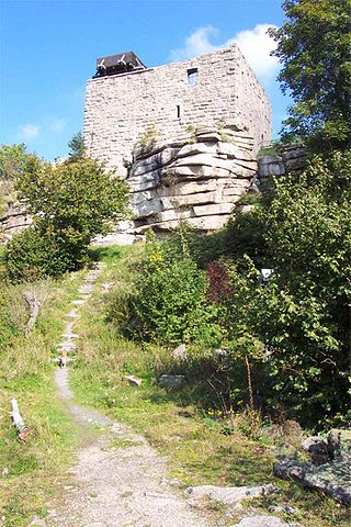
The Waldsteinburg, also called the Red Castle is a ruined castle on the summit of the Großer Waldstein in the Fichtel Mountains of Germany. It is also known as the Westburg to distinguish it from the older ruins of the Ostburg.

With its 827-metre-high (2,713 ft) peak the Große Kornberg is the northeast cornerstone of the Fichtel Mountains in south Germany. It forms a wooded ridge, which is recognisable from a long distance by its former military surveillance tower It is also the local 'house' mountain of Schönwald and Schwarzenbach an der Saale.
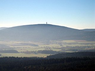
The Epprechtstein is a mountain in the northern Fichtel Mountains in northeast Bavaria, Germany, 798 m above sea level (NN). It is mineralogically the most interesting mountain in the entire Fichtel range. Around the summit there are about 20 quarries, in three of which Epprechtstein granite is quarried. The others are closed and partially overgrown.

Wunsiedel Marble is a group of metamorphic carbonate rocks, which were, and are, mainly extracted in the German town Wunsiedel at several quarries. This Upper Franconian calcite marble occurs both in this region and beyond, particularly in Bavaria. It is found in a northern band and southern band.
The Buchberg is a 674-metre-high mountain in the Bavarian Fichtel Mountains.
Epprechtstein Castle is a former hill castle on the mountain of the same name, the Epprechtstein, which rises above the village of Kirchenlamitz.

The Bergkopf is an 857 metre high, thickly forested mountain in the Sparneck Forest in Germany's Fichtel Mountains.

The White Main Spring is the source of the White Main river, the right-hand and northern headstream of the River Main, a major tributary of the Rhine in Germany. It is located at a height of 887 metres above sea level on the eastern slopes of the Ochsenkopf mountain and is viewed as the source of the Main, even though the Red Main is several kilometres longer. Usually the White Main Spring is stronger than the Red Main Spring.