Ostholstein is a district in Schleswig-Holstein, Germany. It is bounded by the districts of Stormarn, Segeberg and Plön, the Baltic Sea and the city of Lübeck. Geographically, the district covers the vast majority of what is considered to be the peninsular of Wagria.
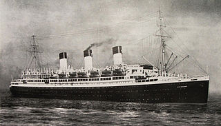
SS Cap Arcona, named after Cape Arkona on the island of Rügen, was a large German ocean liner, later a requisitioned auxiliary ship of the Kriegsmarine, and finally a prison ship in the later months of World War II (1939–1945). A flagship of the Hamburg Südamerikanische Dampfschifffahrts-Gesellschaft, she made her maiden voyage on 29 October 1927, carrying passengers and cargo between Germany and the east coast of South America, and for a brief period of time she was the largest and fastest ship on the route, until one month later she was surpassed on the same Europe-South America route by the Italian liner MS Augustus.
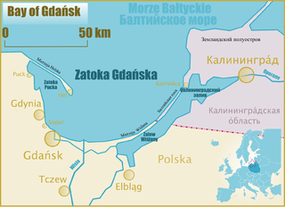
Gdańsk Bay or the Gulf of Gdańsk is a southeastern bay of the Baltic Sea. It is named after the adjacent port city of Gdańsk in Poland.

The Bay of Pomerania is a basin in the southwestern Baltic Sea, off the Pomeranian shores of Poland and Germany. It stretches between the northernmost tip of the island of Rugia called Gellort northwest of Cape Arkona in the west, and the village of Jarosławiec in the east. In the south, it is bounded by the islands of Usedom/Uznam and Wolin, which separate it from the Szczecin Lagoon which is flown through by the Oder River, and is connected to the bay by three straits, the Dziwna, Świna, and Peenestrom.

The Bay of Mecklenburg, also known as the Mecklenburg Bay or Mecklenburg Bight, is a long narrow basin making up the southwestern finger-like arm of the Baltic Sea, between the shores of Germany to the south and the Danish islands of Lolland, Falster, and Møn to the north, the shores of Jutland to the west, and joining the largest part of the Baltic to the east.

The Bay of Lübeck is a basin in the southwestern Baltic Sea, off the shores of the German states of Mecklenburg-Vorpommern and Schleswig-Holstein. It forms the southwestern part of the Bay of Mecklenburg.

The Bay of Kiel or Kiel Bay is a bay in the southwestern Baltic Sea, off the shores of Schleswig-Holstein in Germany and the islands of Denmark. It is connected with the Bay of Mecklenburg in the east, the Little Belt in the northwest, and the Great Belt in the North.

The Heligoland Bight, also known as Helgoland Bight, is a bay which forms the southern part of the German Bight, itself a bay of the North Sea, located at the mouth of the Elbe river. The Heligoland Bight extends from the mouth of the Elbe to the islands of Heligoland and lies between the East Frisian island of Wangerooge and the North Frisian peninsula of Eiderstedt.

Eckernförde Bay is a firth and a branch of the Bay of Kiel between the Danish Wahld peninsula in the south and the Schwansen peninsula in the north in the Baltic Sea off the lands of Schleswig-Holstein, Germany. The bay extends around 17 km (11 mi) deep into the land and is 10 km (6.2 mi) wide at its entrance where Booknis-Eck and Danish-Nienhof mark the endpoints. The bay is up to 28 m (92 ft) deep. The border to the Kiel Fjord lies at the Bülk Lighthouse. The once forested Danish Wahld peninsula between Kiel Fjord and Eckernförde Bay constituted the borderland between the Saxons and the Danes until the Middle Ages. At the inner end of the bay lies the town of Eckernförde.

Behrensdorf is a municipality in the district of Plön, in Schleswig-Holstein, Germany. It lies on the western shore of Hohwacht Bay on the Baltic Sea coast. About one kilometre to the north is the eighty-year-old Neuland Lighthouse.

Hohwacht is a municipality in the district of Plön, in Schleswig-Holstein, Germany. It lies within the region of Wagria and its subordinate parishes are Hohwacht, Haßberg, Neudorf, Niedermühle and Schmiedendorf. The village was first mentioned in 1557 as Hohenwacht.
Geltinger Bucht is an Amt in the district of Schleswig-Flensburg, in Schleswig-Holstein, Germany. Its seat is in Steinbergkirche. It was formed on 1 January 2008 from the former Ämter Gelting and Steinbergkirche.

Wagria is the northeastern part of Holstein in the German state of Schleswig-Holstein, corresponding roughly to the districts of Plön and Ostholstein. The word "Wagria" is derived from the Slavic Lechites tribe of Wagri.
The Kossau is a stream in the district of Plön in eastern Schleswig-Holstein, Germany. It drains the lake Tresdorfer See and flows past Lütjenburg and through the Großer Binnensee before entering the Baltic Sea near Hohwacht. The stream was dammed near Rantzau Castle in the Middle Ages to form a lake which existed until the 18th century. It is about 22 kilometres (14 mi) long and most of its course consists of meanders. It is largely in a natural state and, together with its wet meadows, forms a rich habitat. The Kossau Valley is a designated nature reserve.

The Bay of Meldorf also called Meldorf Bay, is a bay on the coast of the North German state of Schleswig-Holstein, which forms part of the Heligoland Bight.

The Bundesstraße 430 is a German federal road or Bundesstraße and the east-west link between Dithmarschen and Holstein in the southern part of the state of Schleswig-Holstein.

Neuland Lighthouse is a lighthouse in the north German state of Schleswig-Holstein on the Baltic Sea coast that was in service from 1918 to 1996. It stands on the western shore of Hohwacht Bay about 1 kilometre north of the village of Behrensdorf.

Gelting Bay, sometimes also the Bay of Gelting, is a bight of the Baltic Sea on the northeastern coast of the region of Anglia at the exit to the Flensburg Fjord near the town of Gelting. The bay extends from Habernis in the northwest via Wackerballig to the south to the nature reserve of Geltinger Birk in the east. The length of the shoreline along the bay is about 15 kilometres. There are currently no commercial shipping routes across the bay.

Tümlau Bay is a bay on the west coast of the Eiderstedt peninsula in Germany. It is the last large bay on the North Frisian coast that has not been fully dyked off. The southern part of the bay lies in the municipality of Tümlauer-Koog; the northern shore is part of Westerhever. A prominent landmark on the bay is the Westerheversand Lighthouse.

The Bay of Husum, Husum Bight or Husum Bay is a bay on the North Sea coast of the German state of Schleswig-Holstein. Its German name is used for marketing the holiday region around the town of Husum.
