
Easington was, from 1974 to 2009, a local government district in eastern County Durham, England. It contained the settlements of Easington, Seaham, Peterlee, Murton, Horden, Blackhall, Wingate and Castle Eden. It did not however include Easington Lane which is administered as part of the City of Sunderland.

Carrickfergus Castle is a Norman castle in Northern Ireland, situated in the town of Carrickfergus in County Antrim, on the northern shore of Belfast Lough. Besieged in turn by the Scottish, Irish, English and French, the castle played an important military role until 1928 and remains one of the best preserved medieval structures in Northern Ireland. It was strategically useful, with 3/4 of the castle perimeter surrounded by water. Today it is maintained by the Northern Ireland Environment Agency as a state care historic monument, at grid ref: J4143 8725.

Sliabh Liag, sometimes Slieve League or Slieve Liag, is a mountain on the Atlantic coast of County Donegal, Ireland. At 596 metres (1,955 ft), it has some of the highest sea cliffs on the island of Ireland. Although less famous than the Cliffs of Moher in County Clare, Slieve League's cliffs reach almost three times higher.

Jervis Inlet is one of the principal inlets of the British Columbia Coast, about 95 km (59 mi) northwest of Vancouver, and the third of such inlets north of the 49th parallel north, the first of which is the Burrard Inlet, Vancouver's harbour. .

The Gulf of Nicoya is an inlet of the Pacific Ocean. It separates the Nicoya Peninsula from the mainland of Costa Rica, and encompasses a marine and coastal landscape of wetlands, rocky islands and cliffs.

Lawyers Head is a prominent landmark on the coast of Otago, New Zealand. Located within the city of Dunedin, this rocky headland juts into the Pacific Ocean at the eastern end of the city's main beach, Saint Kilda Beach. It is named for the likeness of the cliff face to the profile of a lawyer in traditional legal wig.

Indian Arm is a steep-sided glacial fjord adjacent to the city of Vancouver in southwestern British Columbia. Formed during the last Ice Age, it extends due north from Burrard Inlet, between the communities of Belcarra and the District of North Vancouver, then on into mountainous wilderness. Burrard Inlet and the opening of Indian Arm was mapped by Captain George Vancouver and fully explored days later by Dionisio Alcalá Galiano in June 1792.

OcAcock Inlet is an estuary located in the Outer Banks, North Carolina, United States that separates Ocracoke Island and Portsmouth Island. It connects the Atlantic Ocean to the Pamlico Sound. It is the southern terminus of the Cape Hatteras National Seashore, and the northern terminus of the Cape Lookout National Seashore. The inlet is approximately two miles across, although it changes daily.

Portencross is a hamlet near Farland Head in North Ayrshire, Scotland. Situated about 3 km west of Seamill and about 2 km south of Hunterston B nuclear power station, it is noted for Portencross Castle.

Andersons Bay is a suburb of the New Zealand city of Dunedin. It is located in the southeast of the city's urban area, 2.8 kilometres (1.7 mi) southeast of the city's centre.

Bullock Harbour or Bulloch Harbour is a small working harbour located near the heritage town of Dalkey on the southeast coast of Dublin Bay in Ireland.

Watt Section is a rural community on the Eastern Shore of Nova Scotia, Canada, in the Halifax Regional Municipality. The community is located along Nova Scotia Trunk 7 on the Marine Drive, and is located about 5 km (3.1 mi) southeast of Sheet Harbour, Nova Scotia. The community is located along the eastern side of Sheet Harbour, an inlet of the Atlantic Ocean. The community is named for William Watt, who purchased the land at the present day location of the community in 1844. The cookhouse used at the lumber mill at the head of East River in Sheet Harbour was bought by the residents of Watt Section after the closing of the mill in January 1891, and it was floated down to the community.

Hope Harbour is an inlet at the north-west of West Falkland in the Falkland Islands of the South Atlantic Ocean. About 4 km long and 1.3 km wide, it is sheltered by the promontory of Grave Cove Camp in the south, a narrow ridge terminating in Hope Point to the north, Bramble Point Camp to the east, and West Point Island at its entrance to the west. Carcass Island lies 8 km north-east of Hope Point.

Short Drop Cave and Gavel Pot are different entrances into the same cave system on Leck Fell, in Lancashire, England. The main top entrance, Short Drop Cave, is a small hole in a fenced off shakehole near the main stream sink; Gavel Pot, a window into the system, is a large fenced shakehole some 40-metre (130 ft) deep requiring tackle to descend. There are two other smaller entrances into Short Drop Cave. At its base the system links via a sump with Lost Johns' Cave, and is part of the Three Counties System, an 87 kilometres (54 mi) cave system which spans the borders of Cumbria, Lancashire, and North Yorkshire.
Waddington Harbour is a harbour at the head of Bute Inlet in the Central Coast region of British Columbia, Canada. Also issuing into the head of Bute Inlet and Waddington Harbour, just east of the mouth of the Homathko, is the Teaquahan River. Issuing directly into the inlet a few miles south on the harbour's southeast is the Southgate River, one of the major rivers of the central Pacific Ranges, which begins on the west side of the Lillooet Icecap. Its lower valley adjacent to the inlet's shores is called Pigeon Valley.

Nepean Bay is a bay located on the north-east coast of Kangaroo Island in the Australian state of South Australia about 130 kilometres south-south-west of Adelaide. It was named by the British navigator, Matthew Flinders, after Sir Evan Nepean on 21 March 1802.

Sam Ford Fiord is an isolated, elongated Arctic fjord on Baffin Island's northeastern coast in the Qikiqtaaluk Region of Nunavut, Canada. The Inuit settlement of Pond Inlet is 320 km (200 mi) to the northwest and Clyde River is 80 km (50 mi) to the east.
Seaham Hall Dene railway station was a private railway station that served Seaham Hall, the then a home of the Marquess of Londonderry close to the town of Seaham, County Durham, England from 1875 to 1925 on the Durham Coast Line.

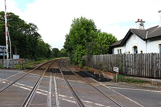
Seaham Harbour railway station was a railway station that served the town of Seaham Harbour in County Durham, North East England. For much of its existence, it was the southern passenger terminus of the Londonderry, Seaham and Sunderland Railway but declined in importance after the opening of the nearby Seaham Colliery station and the extension of the line to West Hartlepool by that company's successor.

