
Bridgewater is a town in Aroostook County, Maine, United States. The population was 532 at the 2020 census.

Gray is a town in Cumberland County, Maine, United States. The population was 8,269 at the 2020 census. It is part of the Portland–South Portland–Biddeford, Maine metropolitan statistical area. Gray is located at the intersection of state Routes 4, 26, 100, 115, 202 and the Maine Turnpike exit 63 midway between the state's two largest cities, Portland and Lewiston. The town includes frontage on Little Sebago Lake, Crystal Lake, and Forest Lake.

Ellsworth is a city in and the county seat of Hancock County, Maine, United States. The 2020 Census determined it had a population of 8,399. Named after United States Founding Father Oliver Ellsworth, it contains historic buildings and other points of interest, and is close to Acadia National Park.
Northwest Somerset is an unorganized territory in Somerset County, Maine, United States. The population was 41 at the 2020 census.

Brunswick is a town in Cumberland County, Maine, United States. The population was 21,756 at the 2020 United States Census. Part of the Portland-South Portland-Biddeford metropolitan area, Brunswick is home to Bowdoin College, the Bowdoin International Music Festival, the Bowdoin College Museum of Art, the Peary-MacMillan Arctic Museum, and the Maine State Music Theatre. It was formerly home to the U.S. Naval Air Station Brunswick, which was permanently closed on May 31, 2011, and has since been partially released to redevelopment as "Brunswick Landing".
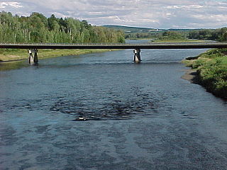
The Aroostook River is a 112-mile-long (180 km) tributary of the Saint John River in the U.S. state of Maine and the Canadian province of New Brunswick. Its basin is the largest sub-drainage of the Saint John River.

Moosehead Lake is a deep, coldwater lake located in Piscataquis County in Northwestern Maine. It is the second-largest lake in New England, and the largest mountain lake in the eastern United States. Situated in the mostly undeveloped Longfellow Mountains, the lake is the source of the Kennebec River. Several rural Townships border the lake. Greenville is by far the largest town on the lake, with a small downtown area that has banks, shops, and restaurants. There are over 80 islands in the lake, the largest being Sugar Island and Deer Island to the west being the second largest.

Maine East High School, or Maine East, and officially Maine Township High School East, is a public four-year high school located at the corner of Dempster Street and Potter Road in Park Ridge, Illinois, a northwest suburb of Chicago, in the United States. It is part of Maine Township High School District 207, which also includes Maine South High School and Maine West High School.

Hurricane Ginny was the strongest recorded tropical cyclone to make landfall in Canada, as well as the latest hurricane on a calendar year to affect the U.S. state of Maine. The eighth tropical storm, as well as the seventh and final hurricane of the 1963 Atlantic hurricane season, Ginny developed on October 16 over the Bahamas, although it was not initially a fully tropical cyclone. As it moved to the North and later northwest, Ginny intensified to hurricane status as it became more tropical. For eight days, it was located within 250 mi (400 km) of the United States coastline. After approaching North Carolina, Ginny looped to the southwest and approached within 50 mi (80 km) of the Florida coastline. It turned to the North, to the East, and later to the northeast, strengthening late in its duration to peak winds of 110 mph (175 km/h). Ginny became an extratropical cyclone shortly after striking Nova Scotia at its peak intensity on October 29.

Maine's 2nd congressional district is a congressional district in the U.S. state of Maine. Covering 27,326 square miles (70,770 km2), it comprises nearly 80% of the state's total land area. The district comprises most of the land area north of the Portland and Augusta metropolitan areas. It includes the cities of Lewiston, Bangor, Auburn, and Presque Isle. The district is represented by Democrat Jared Golden, who took office in 2019.

The Big Black River is a river crossing the administrative region of Chaudière-Appalaches in Quebec and in Maine. From its source, in L'Islet RCM, Quebec, the river runs northeast and east across the Canada–United States border in Maine Township 14, Range 16, WELS, to the Saint John River in Northwest Aroostook T 15, R 13.
The Blackwater River is a 7.1-mile-long (11.4 km) river in Aroostook County, Maine. From the confluence of its North Branch and South Branch in Squa Pan Township (Township 10, Range 4, WELS. The river runs west to St. Croix Stream in Masardis. Via St. Croix Stream and the Aroostook River, the Blackwater River is part of the Saint John River watershed.
The Indian River is a river in Washington County, Maine. From its source in Columbia Falls, the river runs about 12.7 miles (20.4 km) south to its estuary at the village of Indian River in the town of Addison. The tidal portion of the Indian River extends another 3.6 miles (5.8 km) south through the township of Jonesport, and then west to Wohoa Bay, an arm of Western Bay on the Atlantic Ocean. The term "Indian River" is also used to loosely refer to the entire combined townships of Addison and Jonesport through which the river passes.
The Moose River is an 83-mile-long (134 km) river in Maine. Its source is in Beattie, on the Canada–United States border, which runs along the height of land between the watersheds of the Kennebec River in Maine and the Chaudière River in Quebec. From there, the river runs east through Attean Pond and Wood Pond, past the town of Moose River, then through Long Pond and Brassua Lake. The Moose River empties into Moosehead Lake, the source of the Kennebec River, in Rockwood Strip. The International Railway of Maine was built along Moose River in 1889.

The Northwest Branch Saint John River is a 15.5-mile-long (24.9 km) river primarily in Aroostook County, Maine, USA. Its origin is Frontier Lake (Quebec-Maine) in Quebec, Canada. After crossing the Canada–United States border, the Northwest Branch runs south close to the border until it picks up its tributary, the Daaquam River, which also flows out of Canada. The Northwest Branch then runs generally eastward to its confluence with the Southwest Branch to form the Saint John River.
The Roach River is a river in Piscataquis County, Maine. From the outlet of Third Roach Pond in Shawtown, the river runs 19.1 miles (30.7 km) west, through a chain of ponds. The Flow sequence through the ponds is from the Fourth Roach Pond through the Third Roach Pond, Second Roach Pond, and First Roach Pond to empty into Moosehead Lake, the source of the Kennebec River, in Spencer Bay. The Seventh Roach Pond drains through the Sixth Roach Pond in a separate tributary to the Third Roach Pond. No fifth Roach Pond is shown on modern maps.
The South Branch Birch River is a 9.4-mile-long (15.1 km) river in Aroostook County, Maine, in the United States. From the outlet of a small pond in Maine Township 16, Range 9, WELS, it runs southeast and east to its confluence with the North Branch in the town of Eagle Lake to form the Birch River. It is part of the Fish River watershed, draining north to the Saint John River, which flows southeast to the Bay of Fundy in New Brunswick, Canada.
The South Branch Penobscot River is a river in Somerset County, Maine. Its source, Penobscot lake, the north end of which at is about 1,000 feet (300 m) from the Canada–United States border in Sandy Bay. This section of the border runs along the height of land separating the watersheds of the Penobscot River and the Monument River, which feeds into the Saint Lawrence River.
The South Branch Sandy River is a short tributary of the Sandy River in Franklin County, Maine. From its source on Blueberry Mountain in Berlin, the river runs 7.4 miles (11.9 km) northeast to its confluence with the Sandy River in Phillips.

The February 12–14, 2017 North American blizzard was a strong and historic nor'easter that affected the Northeastern United States and Eastern Canada from February 12–14. It impacted the Northeastern United States less than a week after the February 9–11, 2017 North American blizzard. This blizzard was more localized and less widespread than the previous storm, but snow totals were higher in some areas, including portions of Maine and Vermont. The system caused 2 fatalities and is estimated to have caused over $3.9 million in damages. It was unofficially named Winter Storm Orson by The Weather Channel.

