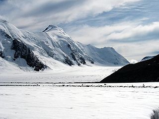
The Bertol Hut is a mountain hut overlooking the Bertol Pass, south of Arolla in the Swiss canton of Valais. It is known for its precarious position on a ridge at 3,311 metres (10,863 ft) south of the Pointe de Bertol and is accessed by a number of fixed ladders and chains from the glacier pass. All accesses to the hut involve glacier crossing. On its east side it overlooks the large plateau of the Mont Miné Glacier.

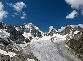
The Argentière Glacier is a glacier in the French Alps. It is one of the larger glaciers found within the Mont Blanc massif, and is situated above the village of Argentière. It lies perpendicular to the Chamonix valley and falls within the Auvergne-Rhône-Alpes region.
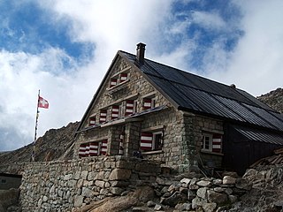
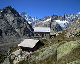
The Trient hut is a mountain hut in the Swiss alps, near the Swiss town of Martigny and the French town of Chamonix. The hut sits at an altitude of 3,170 m (10,400 ft), on a rock perched above the Trient Glacier. It can be reached on foot by mountaineers and strong hikers with experience of glacier travel. From the hut you can walk to the Albert Premier and Argentière huts in France, as well as the Cabane de Saleina (Switzerland) at the foot of the Aiguille d'Argentière. The hut is run by the SAC, the Swiss Alpine Club, and has 130 beds. It is a popular base for mountaineers exploring the area, e.g. Aiguille du Tour etc.

The Saleina Hut is a mountain hut in the Swiss Alps at 2,691 meters above sea level. It can be reached from the Val Ferret. The hut lies above the Saleina Glacier near the Aiguille d'Argentière in the Mont Blanc Massif, and has places for 48 people and is wardened between mid-June to mid-September.
The Saleina Glacier is a 6 km (3.7 mi) long glacier (2002) situated on the north-eastern edge of the Mont Blanc Massif in the canton of Valais in Switzerland. It flows in a roughly north-easterly direction from the Aiguille d'Argentière, down towards the Val Ferret. The Saleina Hut sits above its right bank at an altitude of 2,691 meters above sea level.

The Konkordia Hut is a mountain hut of the Swiss Alpine Club, located north of Fieschertal in the canton of Valais. The hut lies above Konkordiaplatz, the point of convergence of several glaciers in the great Aletsch Glacier system of the Bernese Alps. It is located at a height of 2,850 metres above sea level, at the foot of the Fülbärg.
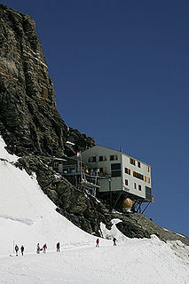
The Mönchsjoch Hut is a mountain hut located in the Bernese Alps in the canton of Valais in Switzerland. At an altitude of 3,658 metres (12,001 ft) is one of the highest huts owned by the Swiss Alpine Club.

The Tracuit Hut is a mountain hut of the Swiss Alpine Club, located above Zinal in the canton of Valais. The hut lies at an elevation of 3,256 metres (10,682 ft) above sea level, at the Tracuit Pass, between Les Diablons and the Tête de Milon in the Pennine Alps.

The Britannia Hut is a mountain hut of the Swiss Alpine Club, located south of Saas-Almagell in the canton of Valais. The hut lies at a height of 3,030 metres above sea level, at the foot of the Allalinhorn near the Allalin Glacier, in the Mischabel massif. It is a starting point for the ascents of Strahlhorn, Rimpfischhorn and Allalinhorn.

The Dom Hut is a mountain hut of the Swiss Alpine Club, located above Randa in the canton of Valais. The hut lies on the western sloped of the Dom, at a height of 2,940 m above sea level, near the bottom of the Festigletscher glacier in the Pennine Alps.

The Schönbiel Hut is a mountain hut located north of the Matterhorn. It is situated at 2,694 metres (8,839 ft) above sea level, north of the Zmutt Glacier, a few kilometers west of the town of Zermatt in the canton of Valais in Switzerland. The actual hut was built by the Swiss Alpine Club in 1955, after the demolition of an older hut, built in 1909.

The Finsteraarhorn Hut is a mountain hut of the Swiss Alpine Club, located north of Fieschertal in the canton of Valais. It lies at a height of 3,048 metres (10,000 ft) above sea level at the southern foot of the Finsteraarhorn, the highest peak of the Bernese Alps. The hut overlooks the upper basin of the Fiescher Glacier, which is among the largest of the range. It is located a few kilometres east of the Grünhornlücke.

The Mischabel Hut is a mountain hut of the Academic Alpine Club of Zurich, located west of Saas Fee in the canton of Valais. It lies at a height of 3,340 metres (10,960 ft) above sea level near the Hohbalmgletscher glacier, on the eastern flanks of the Dom and the Lenzspitze in the Mischabel group.
The Oberaarjoch Hut is a mountain hut of the Swiss Alpine Club, located north of Fieschertal in the canton of Valais, close to the canton of Bern. The hut lies at a height of 3,258 metres above sea level at the foot of the Oberaarhorn, just above the Oberaarjoch, the glacier pass connecting the Fiescher Glacier from the Oberaar Glacier. All accesses to the hut involve glacier crossing.

The Dent Blanche Hut is a mountain hut of the Swiss Alpine Club, located south of Les Haudères in the canton of Valais. The hut lies at a height of 3,507 metres above sea level, at the foot of the Dent Blanche in the Pennine Alps. The hut, located at the upper end of the valley of Hérens near the watershed with the valley of Zermatt, overlooks the Ferpècle Glacier.

The Weisshorn Hut is a mountain hut of the Swiss Alpine Club, located above Randa in the canton of Valais. It is located on the southern slopes of the Weisshorn, at a height of 2,932 metres above sea level, near the bottom of the Schali Glacier.
The Lauteraar Hut is a mountain hut of the Swiss Alpine Club, located south-west of Handegg in the canton of Bern. The hut lies at a height of 2,392 metres (7,848 ft) above sea level, above the Unteraar Glacier, at the foot of the Hienderstock in the Bernese Alps.

The Dix Hut is a mountain hut of the Swiss Alpine Club, located south of Hérémence in the canton of Valais. The hut lies above the Cheilon Glacier, at a height of 2,928 metres above sea level, approximately halfway between the Lac des Dix and the Mont Blanc de Cheilon.

The Rottal Hut is a mountain hut of the Swiss Alpine Club, located south of Lauterbrunnen in the canton of Bern. It lies at a height of 2,755 metres above sea level, above the Rottal Glacier on the western slopes of the Jungfrau.

The Mutthorn Hut is a mountain hut of the Swiss Alpine Club, located between Kandersteg and Lauterbrunnen in the canton of Bern. It lies at a height of 2,900 metres above sea level, above the watershed between the Kander Glacier and the Tschingel Glacier, at the foot of the Mutthorn.