
The Metropolitan Borough of Dudley is a metropolitan borough of West Midlands, England. It was created in 1974 following the Local Government Act 1972, through a merger of the existing Dudley County Borough with the municipal boroughs of Stourbridge and Halesowen.

Brierley Hill is a town and electoral ward in the Metropolitan Borough of Dudley, West Midlands, England, 3 miles (4.8 km) south of Dudley and 1 mile (1.6 km) north of Stourbridge. Part of the Black Country and in a heavily industrialised area, it has a population of 13,935 at the 2011 census. It is best known for glass and steel manufacturing, although the industry has declined considerably since the 1970s. One of the largest factories in the area was the Round Oak Steelworks, which closed down and was redeveloped in the 1980s to become the Merry Hill Shopping Centre. Brierley Hill was originally in Staffordshire.

Kingswinford is a town of the Metropolitan Borough of Dudley in the English West Midlands, situated 5 miles (8 km) west-southwest of central Dudley. In 2011 the area had a population of 25,191, down from 25,808 at the 2001 Census.

Amblecote is a village in the Metropolitan Borough of Dudley in the West Midlands, England. It lies immediately north of the historic town of Stourbridge on the southwestern edge of the West Midlands conurbation. Historically, Amblecote was in the parish of Oldswinford, but unlike the rest of the parish it was in Staffordshire, and as such was administered separately. It borders Audnam, Quarry Bank and Wollaston.

Pensnett is a village of the Metropolitan Borough of Dudley, West Midlands County, England, 2 miles (3.2 km) south-west of Dudley. Pensnett has been a part of Dudley since 1966, when the Brierley Hill Urban District, of which it was a part, was absorbed into the County Borough of Dudley, later the Metropolitan Borough of Dudley from 1974.

Stourbridge is a constituency in West Midlands represented in the House of Commons of the UK Parliament since 2024 by Cat Eccles from the Labour Party.
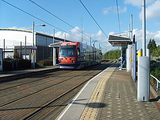
Wednesbury Great Western Street tram stop is a tram stop in Wednesbury, Sandwell, England. It was opened on 31 May 1999 and is situated on West Midlands Metro Line 1. The stop is next to the West Midlands Metro tram depot.
The County Borough of Dudley was a local government district in the English Midlands from 1865 to 1974. Originally a municipal borough, it became a county borough in 1889, centred on the main town centre of Dudley, along with the suburbs of Netherton and Woodside. Although surrounded by Staffordshire, the borough was associated with Worcestershire for non-administrative purposes, forming an exclave of the county until 1966, when it was transferred to Staffordshire after an expansion of the borough boundaries. Following local government reorganization in 1974, Dudley took in the boroughs of Halesowen and Stourbridge to form the present-day Metropolitan Borough of Dudley, in the newly formed West Midlands county.
The Priory Estate is a housing estate in Dudley, West Midlands, England, which has largely been developed since 1929.
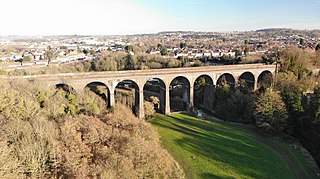
Stambermill Viaduct is a viaduct situated in Stourbridge, West Midlands, England. It was constructed in 1850 to carry the Oxford Worcester and Wolverhampton Railway across the River Stour, and it carried passenger trains until 1964. It is still in use for goods trains, as the railway continues on to the Round Oak Steel Terminal at Brierley Hill. Freight trains can still be seen passing over the viaduct.

Round Oak Steel Terminal is a railway freight terminal dealing in steel from the Round Oak Steel Works until 1982 and from other sources thereafter, in Brierley Hill, West Midlands, England managed by Tata Steel Europe.
Cradley High School was a secondary school located in the Cradley area of Halesowen, which is a village in the West Midlands county of England. It is situated in the west end of Halesowen near the borders with Stourbridge and Brierley Hill, namely Homer Hill. As of 2006, the school had 606 pupils on roll.

Woodside is a residential area of Dudley in the West Midlands of England.

Delph Locks or the Delph Nine are a series of eight narrow canal locks on the Dudley No. 1 Canal in Brierley Hill, in the West Midlands, England. They were opened in 1779, and reopened in 1967 following restoration of the Dudley Canal and the Stourbridge Canal in a joint venture between the Staffordshire and Worcestershire Canal Society and the British Waterways Board.
Thorns Collegiate Academy is a coeducational secondary school located in Brierley Hill, West Midlands, England.
Wolverhampton Street School was a secondary school located in Dudley, Worcestershire, England.
This article details a number of defunct schools that were once located in the Metropolitan Borough of Dudley. For details of currently operating schools in the area, please see: List of schools in Dudley.

Pegasus Academy is a mixed secondary school located in the Holly Hall area of Dudley, West Midlands, England. Situated by the Scotts Green roundabout near the Russells Hall Estate, it was originally opened in 1968 to replace an earlier, smaller building several hundred yards further along the road towards Brierley Hill.