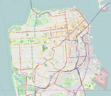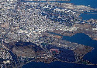
Bayview–Hunters Point is the San Francisco, California, neighborhood combining the Bayview and Hunters Point neighborhoods in the southeastern corner of the city. The decommissioned Hunters Point Naval Shipyard is located within its boundaries and Candlestick Park, which was demolished in 2015, was on the southern edge. Due to the South East location, the two neighborhoods are often merged. Bayview–Hunter's Point has been labeled as San Francisco's "Most Isolated Neighborhood".

Bernal Heights is a residential neighborhood in southeastern San Francisco, California. The prominent Bernal Heights hill overlooks the San Francisco skyline and features a microwave transmission tower. The nearby Sutro Tower can be seen from the Bernal Heights neighborhood.

Mission Dolores Park, often abbreviated to Dolores Park, is a city park in San Francisco, California. It is located two blocks south of Mission Dolores at the western edge of the Mission District.

John McLaren Park is a park in southeastern San Francisco. At 312.54 acres (126.48 ha), McLaren Park is the third largest park in San Francisco by area, after Golden Gate Park and the Presidio. The park is surrounded mostly by the Excelsior, Crocker-Amazon, Visitacion Valley, Portola and University Mound neighborhoods.
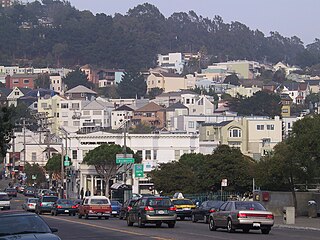
Glen Park is a residential neighborhood in San Francisco, California, located south of Twin Peaks and adjacent to Glen Canyon Park.
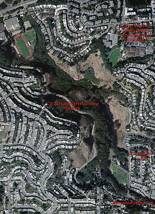
Glen Canyon Park is a city park in San Francisco, California. It occupies about 70 acres (28 ha) along a deep canyon adjacent to the Glen Park, Diamond Heights, and Miraloma Park neighborhoods. O'Shaughnessy Hollow is a rugged, undeveloped 3.6 acres (1.5 ha) tract of parkland that lies immediately to the west and may be considered an extension of Glen Canyon Park.

Diamond Heights is a neighborhood in central San Francisco, California, roughly bordered by Diamond Heights Boulevard and Noe Valley to the north and east and Glen Canyon Park to the south and west. It is built on three hills: Red Rock Heights on the northwest, Gold Mine Hill in center, and Fairmount Heights on the southeast.

The Randall Museum is a museum in central San Francisco, California, owned and operated by the San Francisco Recreation & Parks Department with the support of the Randall Friends. The museum focuses on science, nature and the arts. On exhibit are live native and domestic animals and interactive displays about nature. Other facilities include a theater, a wood shop, and art and ceramics studios.

The San Francisco and San Jose Railroad (SF&SJ) was a railroad which linked the communities of San Francisco and San Jose, California, running the length of the San Francisco Peninsula. The company incorporated in 1860 and was one of the first railroads to employ Chinese laborers in its construction. It opened the first portion of its route in 1863, completing the entire 49.5-mile (80 km) route in 1864. The company was consolidated with the Southern Pacific Railroad in 1870. Today, Caltrain and the Union Pacific Railroad continue to operate trains over part of the company's original route.

Precita Eyes Muralists Association is a community-based non-profit muralist and arts education group located in the Bernal Heights neighborhood of San Francisco, California. It was founded in 1977 by Susan and Luis Cervantes.

India Basin is neighborhood, named after the body of water, in the southeastern part of San Francisco, California, considered to be part of the larger Bayview–Hunters Point neighborhood.

Corona Heights Park is a park in the Castro and Corona Heights neighborhoods of San Francisco, California, United States. It is situated immediately to the south of Buena Vista Park. Corona Heights is bounded in part by Flint Street on the east, Roosevelt Way to the north, and 16th Street to the south. The base of the hill is at approximately 300 feet (91 m), while the peak extends to 520 feet (160 m) above sea level.
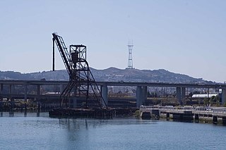
Islais Creek or Islais Creek Channel is a small creek in San Francisco, California. The name of the creek is derived from a Salinan Native American word "slay" or "islay", the name for the Prunus ilicifolia wild cherries. Around the time of the Gold Rush, the area became an industrial hub, and the condition of the creek worsened. After the devastating 1906 San Francisco earthquake, the city decided to reclaim the creek using earthquake debris, reducing the waterbody to its present size. Though much of Islais Creek has been converted to an underground culvert, remnants still exist today at both Glen Canyon Park and Third Street. Several community organizations are dedicated to preserve these remnants, as they are important wildlife habitats.

Bernal Heights Summit or Bernal Heights Hill is a hill in the San Francisco, California neighborhood of Bernal Heights. Upper elevations are part of Bernal Heights Park, which is managed by the San Francisco Recreation & Parks Department. At its highest elevation (466 ft.) is a privately owned equipment building and 50-foot tall telecommunications tower. The tower does not have an official name, but some residents call it "Sutrito", as it resembles a shorter version of Sutro Tower. The park and summit are largely surrounded by Bernal Heights Boulevard.

The Santa Teresa Hills are a range of mountains in Santa Clara County, California, located primarily in the city of San Jose. They separate the San Jose neighborhoods of Almaden Valley to the west and Santa Teresa to the east.
Rancho Rincón de las Salinas y Potrero Viejo was a 4,446-acre (17.99 km2) Mexican land grant, largely within present day southeastern San Francisco, California, and extending to San Mateo County, California.

Bayview Park is a 46.63-acre (18.87 ha) park in the Bayview-Hunters Point neighborhood of southeast San Francisco. The park's land is mainly occupied by a large hill named either Bayview Hill or Candlestick Hill, west of the former site of Candlestick Park and east of the Bayshore Freeway; it is prominently visible from both. The hill was initially proposed as parkland by Daniel Burnham in his 1905 Burnham Plan for San Francisco as Visitacion Park, but the park was not created until 1915. Prior to that, the title to the land was held by the Bay View Land Company, which intended to erect luxury houses on the site. After plans for housing fell through, it was proposed to create a pest house on the site in 1902 until the Crocker Land Company donated adjacent land to the city to block plans for the pest house. KYA (1260 AM) opened a studio and 5000-watt radio transmitter on the hill in 1937, and further development of the area occurred in 1958, when part of the hill was quarried to create fill and land for Candlestick Park. Currently, the park receives relatively few visitors to what is considered one of the best-preserved remnants of pre-Columbian open spaces in San Francisco.

Precita Creek is a small creek in the Bernal Heights and Mission District neighborhoods of San Francisco, California. Its course is mirrored by the current Precita Avenue, which ran along the creek when it was laid out sometime during the early 1850s. The creek gets its name from precita, the Spanish word meaning dam or weir. The stream was buried before the beginning of the 20th century.

