
Rutherglen is a town in South Lanarkshire, Scotland, immediately south-east of the city of Glasgow, three miles from its centre and directly south of the River Clyde. Having previously existed as a separate Lanarkshire burgh, in 1975 Rutherglen lost its own local council and administratively became a component of the City of Glasgow District within the Strathclyde region. In 1996 the towns were reallocated to the South Lanarkshire council area.

Cathcart is an area of Glasgow between Battlefield, Mount Florida, King's Park, Muirend and Newlands. The White Cart Water flows through Cathcart, downstream from Linn Park. In 2014, it was rated one of the most attractive postcode areas to live in Scotland.

Pollokshields is an area in the Southside of Glasgow, Scotland. Its modern boundaries are largely man-made, being formed by the M77 motorway to the west and northwest with the open land of Pollok Country Park and the Dumbreck neighbourhood beyond, by the Inverclyde Line railway and other branches which separate its territory from the largely industrial areas of Kinning Park, Kingston and Port Eglinton, and by the Glasgow South Western Line running from the east to south, bordering Govanhill, Strathbungo, Crossmyloof and Shawlands residential areas. There is also a suburban railway running through the area.
Glasgow South is a burgh constituency of the House of Commons of the Parliament of the United Kingdom (Westminster). It elects one Member of Parliament (MP) by the first past the post system of election.
Mount Florida is an area in the south-east of the city of Glasgow, Scotland.
Donaldson's School is Scotland's national school for the deaf. Originally situated in Edinburgh, it moved to a new location in Linlithgow in 2008. It is a residential and day school that provides education, therapy and care for pupils who are deaf or who have communication difficulties.
Croftfoot is a residential area on the southeastern side of the Scottish city of Glasgow. It is bordered by Castlemilk to the south and King's Park to the west within Glasgow, and by the Rutherglen areas of Spittal to the east and Bankhead to the north. Historically within the civil parish of Cathcart in Renfrewshire, it is within the Linn ward of Glasgow City Council.
Sighthill is a neighbourhood in the Scottish city of Glasgow. It is situated north of the River Clyde and is part of the wider Springburn district in the north of the city. It is bordered to the north by Cowlairs, to the east by the Springburn Bypass road and the Royston neighbourhood, to the west by the Glasgow to Edinburgh via Falkirk Line and to the south by the Townhead interchange of the M8 Motorway.

Newlands is a suburb in the south side of Glasgow, Scotland. The area is mainly residential in character. Shawlands and Langside lie to the north of the district, Pollokshaws and Auldhouse to the west, Giffnock to the south, and Merrylee and Cathcart to the east.
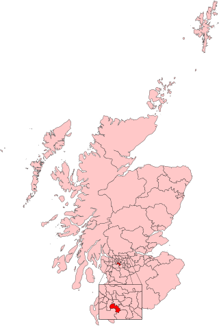
Simshill is an area of Glasgow, Scotland. It is on the South Side of the city, approximately 3.7 miles (6.0 km) south of the city centre. Adjacent areas are Cathcart, King's Park, Croftfoot and Castlemilk. Linn Park is to the south-west of Simshill.
Merrylee is a neighbourhood in the Scottish city of Glasgow. It is situated south of the River Clyde within the Newlands/Auldburn ward surrounded by other residential areas: Newlands, Cathcart and Muirend, and is a housing scheme consisting of mostly ex-local authority homes constructed in the 1950s and 60s.

King's Park is a district in the city of Glasgow, Scotland. It is situated south of the River Clyde and borders the Glasgow areas of Croftfoot, Cathcart, Simshill, Mount Florida and Toryglen and the neighbourhood of Bankhead in the adjoining town of Rutherglen.

Pacific Quay is an area south of the River Clyde in Glasgow, Scotland. It is located at the former Plantation Quay and Princes' Dock Basin. The Princes' Dock Basin was the largest on the River Clyde when it was opened by the Clyde Navigation Trust in 1900. It ceased to be used as a commercial dock by the Clyde Port Authority in the 1970s as the volume of Shipping using the Upper Clyde declined with the onset of containerization. The site was later used for the Glasgow Garden Festival in 1988. The former electric generating station and pumping house, "Four Winds" which was used to pump water between the rotundas and generate power for the electric cranes still stands and is now home to a consultant engineers and radio station. The name 'Pacific Quay' has no historical significance, as it was created simply as a marketing enterprise following the land being reclaimed for commercial use after the Garden Festival closure. It did not reflect the site as a departure point for ships bound for the Pacific Rim.

Duke Street is a major street in Glasgow, Scotland, and is of the major road arteries connecting the City Centre to the East End. It begins at High Street and runs east through the residential districts of Ladywell and Dennistoun, and on towards Haghill and Parkhead, meeting the Gallowgate, Tollcross Road and Westmuir Street to form a turreted Edwardian junction at Parkhead Cross. It takes its name from the Duke of Montrose. At a total distance of 2 miles (3.2km), Duke Street is the longest designated street in Glasgow.
Scotus College was a seminary in Bearsden, Glasgow. It was founded in 1985 under the name of Chesters College and in 1993 was reconstituted as Scotus College. It was then the only remaining Roman Catholic seminary in Scotland.

Clarkston is a suburban town in East Renfrewshire, in the Central Lowlands of Scotland. A dormitory town with a population of around 10,000, Clarkston is on the southern fringe of the Greater Glasgow conurbation and directly adjoins the neighbouring suburban villages of Busby and Netherlee, as well as the towns of Newton Mearns and Giffnock.

Calderwood is a neighbourhood of the Scottish new town of East Kilbride, in South Lanarkshire. It lies on its north-east edge and is one of the largest areas of the town.

Andrew Balfour FRIBA was a Scottish architect.

Cathcart Cemetery is a cemetery in East Renfrewshire, Scotland, which was opened in 1876. It is named after the nearby neighbourhood of Cathcart on the southern outskirts of Glasgow, but does not actually fall within the city boundaries, instead being a salient of East Renfrewshire. It is bounded to the east by the White Cart Water, with Linn Park on the opposite bank. Other surrounding residential areas to the west are Muirend and Netherlee. The grounds of Holmwood House, a mansion designed by Alexander 'Greek' Thomson, are located a short distance to the north.
Queen's Park Secondary School was a secondary school in Glasgow, Scotland.

