History and presence
The first documented mention of Holzlar was in 1394, where it was referred to as “Hultzelar”. Other documented names are Hultzlair, Holtzlar, Holtzlohr, Holzlahr, and Holtzlahr.
In 1757 the brown coal quarrying started for private use. About 50 years later the brothers Leopold and Abraham Bleibtreu bought properties in Holzlar-Kohlkaul und Holzlar Gielgen and began quarrying brown coal and alum.
In 1969 Holzlar became part of Bonn's district Beuel. Before 1969, Holzlar belonged to the Amt Menden.
Today there are mainly housing estates of higher standard in Roleber, Gielgen, Heidebergen and Holzlar. The north of Holzlar-Kohlkaul as well as other areas offer in addition subsidized housing.
Columbia is a town in Washington County, Maine, United States. The population was 435 at the 2020 census.

The River Maun is a river in Nottinghamshire, England. Its source lies in Kirkby-in-Ashfield, and from there it flows north east through Mansfield, Edwinstowe and Ollerton, these being the heart of the Sherwood Forest area. It becomes known as Whitewater near the village of Walesby and connects to the River Meden temporarily where the Robin Hood Way crosses them. They diverge, and near Markham Moor it merges again with the River Meden this time becoming the River Idle. Its main tributaries are Rainworth Water, Vicar Water and Cauldwell Water.

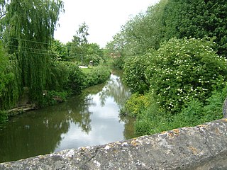
The River Blackwater is a tributary of the Loddon in England and sub-tributary of the Thames. It rises at two springs in Rowhill Nature Reserve between Aldershot, Hampshire and Farnham, Surrey. It curves a course north then west to join the Loddon in Swallowfield civil parish, central Berkshire. Part of the river splits Hampshire from Surrey; a smaller part does so as to Hampshire and Berkshire.

The River Eden is a tributary of the River Medway in south east England. It rises at the foot of the North Downs escarpment near Titsey in Surrey and runs initially southwards through Oxted before turning eastwards to enter Kent. After flowing through Edenbridge and passing Hever Castle, the Eden meets the Medway at Penshurst.
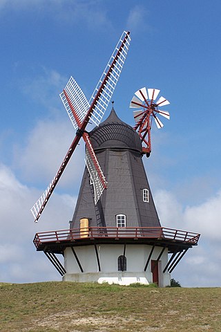
The smock mill is a type of windmill that consists of a sloping, horizontally weatherboarded, thatched, or shingled tower, usually with six or eight sides. It is topped with a roof or cap that rotates to bring the sails into the wind. This type of windmill got its name from its resemblance to smocks worn by farmers in an earlier period.

Lauterecken is a town in the Kusel district in Rhineland-Palatinate, Germany. It is the seat of the Verbandsgemeinde Lauterecken-Wolfstein, to which it also belongs. Lauterecken bears the nickname Veldenzstadt, after the comital family that once held sway here. It is also a state-recognized tourism resort town, and in terms of state planning is laid out as a lower centre.

Rhaunen is an Ortsgemeinde – a municipality belonging to a Verbandsgemeinde, a kind of collective municipality – in the Birkenfeld district in Rhineland-Palatinate, Germany. It was the seat of the former Verbandsgemeinde Rhaunen.
Munesa is one of the Aanaas in the Oromia Regional State of Ethiopia. Part of the Arsi Zone located in the Great Rift Valley, Munesa is bordered on the south and west by the West Arsi Zone and Lake Langano, on the northwest by Batu Dugda, on the north by Tiyo, on the northeast by Digeluna Tijo, and on the east by Bekoji. The administrative center of the woreda is Kersa; other towns in Munesa include Ego.

Natural Bridge State Park is a Massachusetts state park located in the city of North Adams in the northwestern part of the state. Named for its natural bridge of white marble, unique in North America, the park also offers woodland walks with views of a dam made of white marble, and a picturesque old marble quarry.

Schöneberg is an Ortsgemeinde – a municipality belonging to a Verbandsgemeinde, a kind of collective municipality – in the Bad Kreuznach district in Rhineland-Palatinate, Germany. It belongs to the Verbandsgemeinde Langenlonsheim-Stromberg, whose seat is in Langenlonsheim. Schöneberg is a winegrowing village.

Odenbach is an Ortsgemeinde – a municipality belonging to a Verbandsgemeinde, a kind of collective municipality – in the Kusel district in Rhineland-Palatinate, Germany. It belongs to the Verbandsgemeinde Lauterecken-Wolfstein.

The Loose Stream sometimes called the River Loose or Langley Stream is a tributary of the River Medway notable for the number of watermills that it powered in its short length. It rises in Langley, flows through Boughton Monchelsea, Loose and enters the Medway at Tovil. The river valley is deep sided, and there is much evidence of the paper and wool trades which once flourished here: the stream has been dammed in many places, resulting in many mill ponds.
The River Beult is a tributary of the River Medway in South East England.

Hedgecourt is a 33.6-hectare (83-acre) biological Site of Special Scientific Interest (SSSI) north of Felbridge in Surrey. An area of 5 ha is managed by the Surrey Wildlife Trust.
The Medway and its tributaries and sub-tributaries have been used for over 1,150 years as a source of power. There are over two hundred sites where the use of water power is known. These uses included corn milling, fulling, paper making, iron smelting, pumping water, making gunpowder, vegetable oil extraction, and electricity generation. Today, there is just one watermill working for trade. Those that remain have mostly been converted. Such conversions include a garage, dwellings, restaurants, museums and a wedding venue. Some watermills are mere derelict shells, lower walls or lesser remains. Of the majority, there is nothing to be seen. A large number of tributaries feed into the River Medway. The tributaries that powered watermills will be described in the order that they feed in. The mills are described in order from source to mouth. Left bank and right bank are referred to as though the reader is facing downstream. This article covers the tributaries that feed in above Penshurst.
The Medway and its tributaries and sub-tributaries have been used for over 1,150 years as a source of power. There are over two hundred sites where the use of water power is known. These uses included corn milling, fulling, paper making, iron smelting, pumping water, making gunpowder, vegetable oil extraction, and electricity generation. Today, there is just one watermill working for trade. Those that remain have mostly been converted. Such conversions include a garage, dwellings, restaurants, museums and a wedding venue. Some watermills are mere derelict shells, lower walls or lesser remains. Of the majority, there is nothing to be seen. A large number of tributaries feed into the River Medway. The tributaries that powered watermills will be described in the order that they feed in. The mills are described in order from source to mouth. Left bank and right bank are referred to as though the reader is facing downstream. This article covers the watermills on the tributaries that feed in below Penshurst and above Yalding.

Ifield Water Mill is a 19th-century weatherboarded watermill in the Ifield neighbourhood of Crawley, a town and borough in West Sussex, England. Built on the site of an earlier, smaller flour mill, which itself replaced an iron forge—one of many in the Crawley area—it fell into disuse in the 1930s. The local council, which acquired the land for housing development in the 1970s, leased the mill to local enthusiasts, who restored it to working order. The mill and an associated house are listed buildings, and there is also a cottage on the site.

Oberdöbling was an independent municipality until 1892 and is today a part of Döbling, the 19th district of Vienna. It is also one of the 89 Katastralgemeinden.

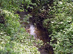
The Alaunbach is a left tributary of the Vilicher Bach in Bonn, district of Beuel. Its total length is 2.51 kilometers and its catchment area is 1.7 square kilometers. It is located in Germany. The creek is heavily anthropogenic, especially in its lower section in the commercial area of Pützchen and in the settlement area of Bechlinghoven. Site-appropriate riparian trees are rarely found. The stream areas above the “Am Rehsprung” allotment gardens are more natural.

Esrum Å is the principal drainage of Lake Esrum, Denmark's second largest lake, located in Gribskov Municipality, some 50 km north of Copenhagen, Denmark. The 10-km-long stream extends from the northwestern part of the lake and flows past Esrum Watermill and Esrum Abbey on its way to The Kattegat at Dronningmølle.