
The Deep Freeze Range is a rugged mountain range, over 128 km (80 mi) long and about 16 km (10 mi) wide, rising between Priestley and Campbell glaciers in Victoria Land, Antarctica, and extending from the edge of the polar plateau to Terra Nova Bay. Peaks in the low and mid portions of the range were observed by early British expeditions to the Ross Sea.

Mornington Island is an island in the Gulf of Carpentaria in the Shire of Mornington, Queensland, Australia. It is the northernmost and largest of 22 islands that form the Wellesley Islands group. The largest town Gununa is on the south-west of the island. The Manowar and Rocky Islands Important Bird Area lies about 40 kilometres (25 mi) to the north-west.
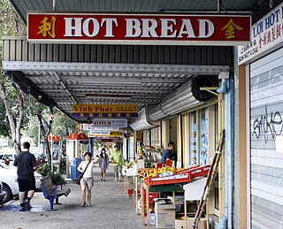
Darra is a Brisbane suburb located about 14 kilometres (8.7 mi) southwest of Brisbane central business district. The first subdivisions in the area occurred in 1864.

Whitsunday Island is the largest island in the Whitsunday group of islands located off the coast of Central Queensland, Australia. Whitehaven Beach was rated as the top Eco Friendly Beach in the world by CNN.com in July 2010. The island should not be confused with Pinaki in the Tuamotu group which was named "Whitsunday Island" by Samuel Wallis in 1767. It is uninhabited today but was once settled by the sea-faring Ngaro people. The first of the logging camps on the island was set up by Eugene Fitzalan in 1861 to exploit the large hoop pine for construction of buildings on the mainland.

The Northumberland Islands are a scattered island chain off the eastern coast of Queensland, Australia.

North Queensland or the Northern Region is the northern part of the Australian state of Queensland that lies just south of Far North Queensland. Queensland is a massive state, larger than many countries, and the tropical northern part of it has been historically remote and undeveloped, resulting in a distinctive regional character and identity.
Cholmondeley Islet is a small island in the Boydong cays Shelburne Bay in far north Queensland, Australia about 105 km north of Cape Grenville, Cape York Peninsula in the Great Barrier Reef Marine Park Queensland, Australia.
Milman Islet is a small island north of Shelburne Bay in far north Queensland, Australia about 140 km North of Cape Grenville, Cape York Peninsula in the Great Barrier Reef Marine Park Queensland, Australia. It is a Hawksbill Turtle nesting site.
Aplin Islet is a small island north of Shelburne Bay in far north Queensland, Australia about 140 km north of Cape Grenville, Cape York Peninsula in the Great Barrier Reef Marine Park Queensland, Australia. It is within the Shire of Cook.

Woombye is a town and locality in the Sunshine Coast Region, Queensland, Australia. In the 2016 census, Woombye had a population of 3,246 people.
The Shire of Mornington is a local government area in north-west Queensland, Australia. The Shire covers Mornington Island and neighbouring islands in the Wellesley Islands group in the Gulf of Carpentaria. The Shire Council employees are 93% local indigenous residents.
South Townsville is a coastal suburb of the City of Townsville, Queensland, Australia. In the 2011 census, South Townsville had a population of 2,138 people.

Willem Janszoon made the first recorded European landing on the Australian continent in 1606, sailing from Bantam, Java, in the Duyfken. As an employee of the Dutch East India Company, Janszoon had been instructed to explore the coast of New Guinea in search of economic opportunities. He had originally arrived in Dutch East Indies from the Netherlands in 1598 and became an officer of the VOC on its establishment in 1602.

Cape Grenville, is a small, east-facing promontory along the Queensland, Australia coast of Cape York Peninsula. It lies between Shelburne Bay to the north and Temple Bay to the south. The nearest significant settlement is Weipa, along the western coast of Cape York.
Griffin is a coastal suburb in Moreton Bay Region, Queensland, Australia. It is north of Brisbane, the state capital. The origin of the suburb name is from the Griffin family who migrated to Australia from the Orkney Islands off the northern coast of Scotland.
Gore Island is an island about 1 km southeast of Cape Grenville in the Great Barrier Reef Marine Park Queensland, Australia, in Temple Bay about 200 km northeast of Iron Range National Park and Lockhart River in the Cape York Peninsula. This island is part of Home Islands. It is also part of the Cape York to Cape Grenville Islands Important Bird Area.
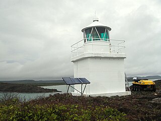
Eborac Island Light is an active lighthouse on Eborac Island, a small rocky island in the Adolphus Channel just off Cape York, the northern tip of Cape York Peninsula, Far North Queensland, Australia. It guides ships into the coastal channel inside the Great Barrier Reef. The concrete structure was built in 1921 and converted to solar power in 1990.
The Town of South Coast was a local government area in South East Queensland, Australia.
Neurum is small rural town in the Moreton Bay Region 65 kilometres (40 mi) north of Brisbane, Australia. At the 2011 Australian Census Neurum recorded a population of 168. The northern boundary is marked by the Stanley River. The eastern boundary is naturally vegetated and elevated along a ridge which peaks at Neurum Mountain which lies within a large reserve.


