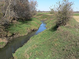
Honey Creek is a stream in Pottawattamie and Harrison counties, Iowa, in the United States. [1] It is a tributary of Missouri River.
Pottawattamie County is a county located in the U.S. state of Iowa. At the 2010 census, the population was 93,158. The county takes its name from the Potawatomi Native American tribe. The county seat is Council Bluffs.
Harrison County is a county located in the U.S. state of Iowa. As of the 2010 census, the population was 14,928. The county seat is Logan. The county was formed in 1851. It was named for ninth US President William Henry Harrison.
Iowa is a state in the Midwestern United States, bordered by the Mississippi River to the east and the Missouri River and Big Sioux River to the west. It is bordered by six states; Wisconsin to the northeast, Illinois to the east, Missouri to the south, Nebraska to the west, South Dakota to the northwest and Minnesota to the north.
The stream headwaters are at 41°33′48″N95°46′51″W / 41.56333°N 95.78083°W and the confluence with the Missouri is at 41°25′25″N95°55′52″W / 41.42361°N 95.93111°W Coordinates: 41°25′25″N95°55′52″W / 41.42361°N 95.93111°W . [1]
In geography, a confluence occurs where two or more flowing bodies of water join together to form a single channel. A confluence can occur in several configurations: at the point where a tributary joins a larger river ; or where two streams meet to become the source of a river of a new name ; or where two separated channels of a river rejoin at the downstream end.
A geographic coordinate system is a coordinate system that enables every location on Earth to be specified by a set of numbers, letters or symbols. The coordinates are often chosen such that one of the numbers represents a vertical position and two or three of the numbers represent a horizontal position; alternatively, a geographic position may be expressed in a combined three-dimensional Cartesian vector. A common choice of coordinates is latitude, longitude and elevation. To specify a location on a plane requires a map projection.
Honey Creek was named by settlers for the great number of honeybees seen at the creek. [2]
Modale is a city in Harrison County, Iowa, United States. The population was 283 at the 2010 census.
Ida Grove is a city in Ida County, Iowa, United States. The population was 2,142 at the 2010 census. It is the county seat of Ida County.
Honey Creek may refer to some places in the United States:
Polwarth is a mainly residential area of Edinburgh, Scotland. It is bounded by Bruntsfield and Merchiston to the east and south, Gorgie and Dalry to the north, Fountainbridge to the north and east, and Craiglockhart to the west.
Rock Creek is a 19.1-mile-long (30.7 km) tributary of the Elkhorn River that flows south of Wisner and enters the Elkhorn one mile west of Beemer. The railway water stop and original plats where the village of Beemer is now located were named "Rock Creek" before Beemer was incorporated as a village in 1886.
The Omaha Blues, Jazz, & Gospel Festival is an annual event of blues, jazz and gospel music that has been held at Rosenblatt Stadium in South Omaha and Fort Omaha in North Omaha, Nebraska in August.
Honey Creek is an unincorporated community in Pottawattamie County, Iowa, United States. Its elevation is 1,014 feet (309 m). Although it is unincorporated, it has a ZIP code of 51542.
California Junction is an unincorporated community and census-designated place (CDP) in Harrison County, Iowa, United States. It lies just east of the junction between the east-west and north-south lines of the former Sioux City and Pacific Railroad. In the 2010 census it had a population of 85 inhabitants and a population density of 184.38 people per square mile (71.19/km²).
The Tarkio River is a non-navigable river that stretches for approximately 140 miles (225 km) from Cass County, Iowa to its mouth on the Missouri River in Holt County, Missouri.
Bell Creek is a stream in Washington, Dodge and Burt counties, Nebraska, in the United States.
Battle Creek is a stream in Ida County, Iowa, in the United States. It is a tributary of the Maple River.
Honey Creek is a stream in Iowa and Poweshiek counties, Iowa, in the United States. It is a tributary of Iowa River.
Lake Creek is a stream in Calhoun and Pocahontas counties, Iowa, in the United States. It is a tributary of the North Raccoon River.
Long Pine Creek is a stream in Rock and Brown counties, Nebraska, in the United States.
Pierson Creek is a stream in Woodbury and Cherokee counties, in the U.S. state of Iowa. It is a tributary of the Little Sioux River.
Plum Creek is a stream in Kossuth and Hancock counties, in the U.S. state of Hancock County, Iowa. It is a tributary of the east fork of the Des Moines River.
Preparation is a ghost town in Monona County, in the U.S. state of Iowa.
Earl is an unincorporated community in Callaway County, in the U.S. state of Missouri.
Honey Creek is a stream in Tayler County, Iowa and Nodaway County, Missouri. It is a tributary of Platte River.
Fox Creek is a stream in southern Taney County, Missouri. It is a tributary of Bee Creek. The headwaters of the stream are just east of Missouri Route JJ west of Mincy. The stream flows southeast passing through a portion of the Drury-Mincy Conservation Area to its confluence with Bee Creek which flows into Bull Shoals Lake to the southeast near the Missouri-Arkansas border.
This article related to a river in Iowa is a stub. You can help Wikipedia by expanding it. |