
Rama-bhadra-puram is a village and Ramabhadrapuram mandal headquarters in Vizianagaram district of Andhra Pradesh, India.
Kurupam is a village in Vizianagaram district of the Indian state of Andhra Pradesh.

Padmanabham mandal is one of the 46 mandals in Visakhapatnam District. It is under the administration of Visakhapatnam revenue division and the headquarters is located at Padmanabham. The Mandal is bounded by Bheemunipatnam, Anandapuram mandals in Visakhapatnam District and Bhogapuram mandal in Vizianagaram District.
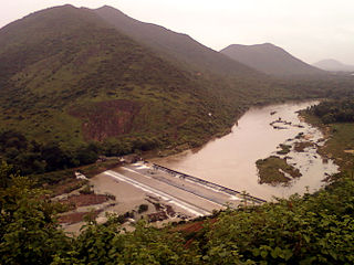
Challapalli, officially known as Challapalle, is a village in Krishna district of the Indian state of Andhra Pradesh. It is located in Challapalli mandal of Machilipatnam revenue division. Challapalli is one of the villages in the mandal to be a part of Andhra Pradesh Capital Region.
Pachi-penta is a village in Vizianagaram district of the Indian state of Andhra Pradesh. It is located in Pachipenta mandal.
Makkuva is a village in Vizianagaram district of the Indian state of Andhra Pradesh.
Mentada is a village in Vizianagaram district of the Indian state of Andhra Pradesh, India.
Denkada is a village in Vizianagaram district of the Indian state of Andhra Pradesh, India. Denkada is located on the banks of River Champavathi.
Vepada is a village in Vizianagaram district of the Indian state of Andhra Pradesh, India.
Lakka-varapu-kota or L. Kota is a village in Vizianagaram district of the Indian state of Andhra Pradesh.
Merakamudidam is a village in Vizianagaram district of the Indian state of Andhra Pradesh, India.
Datti-rajeru is a village and Mandal Headquarters in Vizianagaram district of the Indian state of Andhra Pradesh, India.
Garugu-billi is a village in Vizianagaram district of the Indian state of Andhra Pradesh, India.
Jiyyammavalasa is a village in Vizianagaram district of the Indian state of Andhra Pradesh.
Seethanagaram is a mandal in Vizianagaram district of the Indian state of Andhra Pradesh.
Burja or Boorja is a village in Srikakulam district of the Indian state of Andhra Pradesh. Burja is located near River Nagavali.
Lakshminarasupeta is a village in Srikakulam district of the Indian state of Andhra Pradesh.
Sarubujjili is a village in Srikakulam district of the Indian state of Andhra Pradesh. Sarubujjili mandal is bordered by Burja, Seethampeta, Hiramandalam, Jalumuru and Narasannapeta mandals of Srikakulam district.

Pendurthi is a neighbourhood in the city of Visakhapatnam, India. The neighbourhood is considered as the major residential and commercial area in the district. It is located within the jurisdiction of the Greater Visakhapatnam Municipal Corporation, which is responsible for the civic amenities in Pendurthi. It is located on the west fringe of Visakhapatnam city.
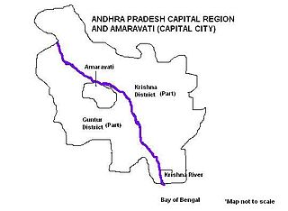
Andhra Pradesh Capital Region is the conurbation or metropolitan area surrounding Amaravati, the new capital city of Andhra Pradesh. The entire region is under the jurisdiction of Andhra Pradesh Capital Region Development Authority, and covers an area of 8,603 km2 (3,322 sq mi) under 58 mandals, of which 29 are in Krishna district and 29 in Guntur district. The capital region covers 18 mandals fully and 11 mandals partially in Guntur district. In Krishna district, it covers 15 mandals fully and 14 mandals partially under the jurisdiction of APCRDA. The capital city is an Urban Notified Area, and will cover 217.23 km2 (83.87 sq mi), within the Andhra Pradesh Capital Region.


