Hoogheemraadschap van Rijnland

Last updated
Gemeenlandshuis of the Hoogheemraadschap van Rijnland on the Breestraat in Leiden Gemeenlandshuis - Leiden.jpg
Gemeenlandshuis of the Hoogheemraadschap van Rijnland on the Breestraat in Leiden

The Hoogheemraadschap van Rijnland is the oldest water authority in the Netherlands, having received commission to coordinate protection of the land from flooding in 1248 from Count William II of Holland and Zeeland. The council conducts surface water management activities in the area known as Rijnland in the province of South Holland. The Netherlands has 21 Waterboards or Waterschappen acting independently from administrative governing bodies to manage Dutch water control activities along with the fine-mazed polder systems. [1]

Contents

History

Count William II of Holland and Zeeland Granting Privileges in 1255 to the local Dike-wardens of Spaarndam by Caesar van Everdingen, 1654, originally commissioned for the Gemeenlandshuis Zwanenburg in Halfweg, and today in the collection of the Gemeenlandshuis Rijnland in Leiden Count William II grants the charter to the Water Board of Rhineland, by Caesar van Everdingen and Pieter Jansz Post.jpg
Count William II of Holland and Zeeland Granting Privileges in 1255 to the local Dike-wardens of Spaarndam by Caesar van Everdingen, 1654, originally commissioned for the Gemeenlandshuis Zwanenburg in Halfweg, and today in the collection of the Gemeenlandshuis Rijnland in Leiden

The first steps towards a governing organisation of water management were taken in the 12th century when the Oude Rijn river silted shut at the North Sea mouth near Katwijk. Even though the Lek river some 60 kilometer upstream had become the main Rhine water drainage channel, the populated area along Oude Rijn, from Utrecht to Leiden, suffered from flooding because the river water couldn't flow properly into the sea anymore. To deal with this problem, the local nobility of Leiden decided to build a dam at Zwadenburg, now Zwammerdam, close to the border with the German Kingdom. This moved the problem upstream the Rhine and people living there, did complain to their king, Frederick I Barbarossa. In 1165, he decided in favor of Utrecht and the dam had to be improved with a sluice, so at low tide water could be drained out of the upstream area towards the sea. [2]

Meanwhile, around Leiden digging work had started to increase the draining efficiency of the small rivers called the "Zyl" and "Does", which would carry the overflow towards the Haarlem Lake and the Kagerplassen. [3] This ambitious project was the result of 15 neighborhoods working together towards a common goal. By 1255, according to the oldest dated document in the Rijnland archives, there was a collaborating group of officials called heemraden who oversaw the dikes along the IJ river at Amsterdam and in the Rhine at Zwammerdam. Their privileges were described in this document that was given to the dike warden of the area between Wassenaar, the Zwammerdam, and Spaarndam. At that time Rijnland was one of the many water districts within the area. Each district had a bailiff, and it was the bailiff who was put in charge of dike maintenance. The term Dijkgraaf (official) began to be used around 1400, when the water district borders differed greatly from the borders of the nearby municipalities. [3]

Heraldic shields of the Halfweg Water Board members in 1646, the year that the Water Board built this house for board meetings, on the facade of the Gemeenlandshuis Zwanenburg in Halfweg. Sugar city 6.jpg
Heraldic shields of the Halfweg Water Board members in 1646, the year that the Water Board built this house for board meetings, on the facade of the Gemeenlandshuis Zwanenburg in Halfweg.

The success of the Zijl and Does river outlets was not enough to avoid heavy floods, and in 1248, a heavy storm again caused a lot of damage, so a dam was built at Spaarndam. This caused a fierce dispute with Haarlem, since that city was dependent on free access for ships to the IJ. The dispute was solved by building an extra sluice in 1253 for ships that could pass when the water levels on both sides of the sluice were the same. [4] To emphasize that control over the sluices and dikes at Spaarndam were under the jurisdiction of the Hoogheemraadschap van Rijnland, Count Willem II granted the privileges to levy a toll on ships to the Dike wardens, and not to the city of Haarlem. It is this document from 1255 that is referred to in the painting by Caesar van Everdingen in 1654. From that point on, the heemraden at Spaarndam were called the heemraden van Rijnland.

This would not be the last time that the city of Haarlem got into an argument with the Hoogheemraadschap van Rijnland. In 1514 a heavy storm broke the sluices and the dike at Spaarndam. Haarlem was happy to have the free passage of ships and refused to repair the dike. When the Hof van Holland decided in favor of repairs, Haarlem asked to have the dam (and sluices with their tolls) moved closer to the city. This would mean that Haarlem would have the dam on its own property, and they would have more control. The heemraden voted against it, and repairs were ordered. In 1517 the dam was not yet ready and Haarlem sent soldiers to destroy the work underway. Again the Hof van Holland needed to mediate the heated tempers and again the decision was in favor of the Heemraden. Haarlem was allowed its own sluice gate for small ships, the Klein Haarlemmersluis, which kept working until 1897, when a new sluice was built. To manage the finances of building and maintaining the dam and all its sluices, it was decided to split the costs (and toll income) among the water boards downstream. Haarlem paid for its own sluice gate, and the Woerdersluis was paid for by the Water board called the Grootwaterschap Woerden, which also released its water overflow via the Spaarndam sluices. [4]

Gemeenlandshuis

The management of these complicated funding arrangements led to the formation of a new governing body in addition to the hoogheemraden, and these were the hoofdingelanden. These were large landowners with the Water board district who could oversee and approve the finances of the Water board. [3] For several centuries, the daily work of the Hoogheemraadschap van Rijnland was run by one Dike warden and seven hoogheemraden, of which two came from Haarlem and five from Leiden. Their responsibilities were traditionally to oversee the dam at Spaarndam and the dikes along the Zijl and the Does.

To meet efficiently, the Hoogheemraadschap bought a meeting hall in 1578, that was also the permanent residence of the Dike warden. The facade was renovated twenty years later in 1598 to keep up with the new town hall. [3] This Gemeenlandshuis is the first one used by the Hoogheemraadschap van Rijnland, but to meet with the Amsterdam Water Board and inspect the dikes along the Haarlemmertrekvaart and the sluices at Halfweg, the Gemeenlandshuis Zwanenburg was built by Pieter Post in 1645-1648. Though nearly demolished today, there is a town named after this building in the Haarlemmermeerpolder called Zwanenburg.

Related Research Articles

<span class="mw-page-title-main">Nederrijn</span> Dutch portion of the Rhine river

Nederrijn is the Dutch part of the Rhine from the confluence at the town of Angeren of the cut-off Rhine bend of Oude Rijn (Gelderland) and the Pannerdens Kanaal. The city of Arnhem lies on the right (north) bank of the Nederrijn, just past the point where the IJssel branches off. The Nederrijn flows on to the city of Wijk bij Duurstede, from where it continues as the Lek. The once-important but now small Kromme Rijn branch carries the name "Rhine" towards the city of Utrecht.

<span class="mw-page-title-main">Oude Rijn (Utrecht and South Holland)</span> River in Netherlands

The Oude Rijn is a branch of the Rhine delta in the Dutch provinces of Utrecht and South Holland, starting west of Utrecht, at Harmelen, and running by a mechanical pumping station into the North Sea at Katwijk. Its present-day length is 52 kilometres.

<span class="mw-page-title-main">Zwammerdam</span> Village in South Holland, Netherlands

Zwammerdam is a village in the Dutch province of South Holland along Oude Rijn river. It is a part of the municipality of Alphen aan den Rijn, and lies about 6 km southeast of Alphen aan de Rijn. The name derives from a dam built in the Rhine river in 1165 AD by Count Floris III of Holland, to protect the land stream downwards from floods.

<span class="mw-page-title-main">Zwanenburg</span> Village in North Holland, Netherlands

Zwanenburg is a town in the Dutch province of North Holland. It is a part of the municipality of Haarlemmermeer, and lies about 11 km west of Amsterdam.

<span class="mw-page-title-main">Halfweg</span> Village in North Holland, Netherlands

Halfweg is a village in the Dutch province of North Holland. Previously a part of the municipality of Haarlemmerliede en Spaarnwoude, it is currently a part of the municipality of Haarlemmermeer and lies about 8 km (5.0 mi) east of Haarlem. Its name, which translates as "halfway," comes from its location approximately halfway between Haarlem and Amsterdam.

<span class="mw-page-title-main">Flood control in the Netherlands</span> Manmade control of flooding in the Netherlands

Flood control is an important issue for the Netherlands, as due to its low elevation, approximately two thirds of its area is vulnerable to flooding, while the country is densely populated. Natural sand dunes and constructed dikes, dams, and floodgates provide defense against storm surges from the sea. River dikes prevent flooding from water flowing into the country by the major rivers Rhine and Meuse, while a complicated system of drainage ditches, canals, and pumping stations keep the low-lying parts dry for habitation and agriculture. Water control boards are the independent local government bodies responsible for maintaining this system.

The Netherlands has several levels of administrative subdivisions. The first level of subdivision consists of 12 provinces. The second level of subdivision consists of 342 municipalities.

<span class="mw-page-title-main">Pieter Post</span> Dutch painter

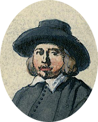
Pieter Jansz Post was a Dutch Golden Age architect, painter and printmaker.

<span class="mw-page-title-main">Haarlemmertrekvaart</span>

The Haarlemmertrekvaart [ˌhaːrlɛmərˈtrɛkfaːrt] is a canal between Amsterdam and Haarlem in the province of North Holland, the Netherlands. It was dug in 1631, making it the oldest tow-canal in Holland. Travel on such canals was historically done by barges which were towed by animals on a path along the canal's edge (towpath).

Nicolaas Samuelszoon Kruik, also known as Klaas Kruik and Nicolaes Krukius, was a Dutch land surveyor, cartographer, astronomer and weatherman. He is commemorated by the Museum De Cruquius.

<span class="mw-page-title-main">Water board (Netherlands)</span> Water management authorities in the Netherlands

In the Netherlands, a water board, water council or water authority is a regional governing body solely charged with the management of surface water in the environment. Water boards are independent of administrative governing bodies like provinces and municipalities. In general, they are responsible for managing rivers and canals, issues with the flow of watercourses and drainage issues, water collection, flood and erosion prevention and provision of potable water. They manage polder systems, water levels, water barriers and locks, enforcements, water quality and sewage treatment in their respective regions. The concept of a coordinating "High Water Authority" (Hoogheemraadschap) originated in what now is the province of South Holland in the 12th century.

<span class="mw-page-title-main">Rijnland</span>

The name Rijnland means "Rhineland" in Dutch. When referring to the Rhine in Germany, "Rijnland" has the same meaning as "Rhineland" in English or "Rheinland" in German. However, "Rijnland" has a specific, different meaning in a Dutch context - the area along the Oude Rijn.

Drainage districts occur in England and Wales, varying in size from a few hundred acres to over 100,000 acres (400 km2), all in low-lying areas of the country where flood risk management and land drainage are sensitive issues. Most drainage districts are administered by an internal drainage board (IDB), which are single purpose local drainage authorities, dealing with the drainage and water level management of clean water only. Each drainage district has a defined area, and the IDB only has powers to deal with matters affecting that area.

<span class="mw-page-title-main">Gemeenlandshuis</span> Building of the headquarters of the Netherlands water authority

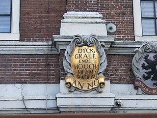
A Gemeenlandshuis, or Waterschapshuis is a building that is the headquarters of one of the Waterboards of the Netherlands.

<span class="mw-page-title-main">Gemeenlandshuis van Rijnland</span>

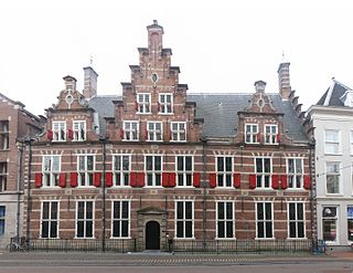
The Gemeenlandshuis van Rijnland on the Breestraat in Leiden is the oldest Gemeenlandshuis of the Netherlands that kept its function until the current century. Currently, it is still in use by the Hoogheemraadschap van Rijnland, but only for meetings and special occasions. Their day-to-day seat of water management is housed today on the Archimedesweg in Leiden.

<span class="mw-page-title-main">Gemeenlandshuis Zwanenburg</span> Former headquarters of the Netherlands water authority

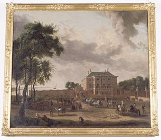
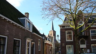
The Gemeenlandshuis Zwanenburg on the Haarlemmerstraatweg in Halfweg is a former Gemeenlandshuis of the Hoogheemraadschap van Rijnland designed by Pieter Post and built 1645–1648.

<span class="mw-page-title-main">Christiaan Brunings</span> Dutch hydraulic engineer (1736–1805)

Christiaan Brunings was a Dutch hydraulic engineer.

<span class="mw-page-title-main">Hoogheemraadschap van Delfland</span> Place in Netherlands

The Hoogheemraadschap van Delfland is a Dutch waterboard, which is responsible for water management. It covers the municipalities of Delft, Midden-Delfland and The Hague, and is fully located in the province of South Holland. The organization was established in 1289 when William I, Duke of Bavaria authorized the "Heemraden of Delft" to manage water and serve as a court.

<i>The Officers of the St George Militia Company in 1639</i> Painting by Frans Hals

The Officers of the St George Militia Company in 1639 refers to the last and largest schuttersstuk painted by Frans Hals for the St. George civic guard of Haarlem, and today is considered one of the main attractions of the Frans Hals Museum in Haarlem.

<span class="mw-page-title-main">Zijl</span> River of the Netherlands

The Zijl is a short river in the Dutch province of South Holland that connects the Old Rhine with the Kagerplassen. The Zijl flows in a south–north direction and is only 4.56 kilometers long, running from the Spanjaardsbrug in the city of Leiden to the Kager plas Zweiland. There are two islands in the Zijl: Zijleiland and Boterhuiseiland. The northern section was previously referred to as the Rechte Zijl, while the southern part was known as the Kromme Zijl.

References

  1. "Over de Unie". Unie van Waterschappen (in Dutch). Retrieved 2020-11-13.
  2. (in Dutch) 'Ontstaan van het Hoogheemraadschap', website Hoogheemraadschap Rijnland
  3. 1 2 3 4 Website Archived 2010-10-22 at the Wayback Machine of the Hoogheemraadschap van Rijnland
  4. 1 2 De Kleine Haarlemmer sluis on the website of the North Holland Archives

Sources