Related Research Articles

Georgetown is the capital and largest city of Guyana. It is situated in Demerara-Mahaica, region 4, on the Atlantic Ocean coast, at the mouth of the Demerara River. It is nicknamed the "Garden City of the Caribbean." It is the retail, administrative, and financial services centre of the country, and the city accounts for a large portion of Guyana's GDP. The city recorded a population of 118,363 in the 2012 census.

The River Rother flows for 35 miles (56 km) through the English counties of East Sussex and Kent. Its source is near Rotherfield in East Sussex, and its mouth is on Rye Bay, part of the English Channel. Prior to 1287, its mouth was further to the east at New Romney, but it changed its course after a great storm blocked its exit to the sea. It was known as the Limen until the sixteenth century. For the final 14 miles (23 km), the river bed is below the high tide level, and Scots Float Sluice is used to control levels. It prevents salt water entering the river system at high tides, and retains water in the river during the summer months to ensure the health of the surrounding marsh habitat. Below the sluice, the river is tidal for 3.7 miles (6.0 km).
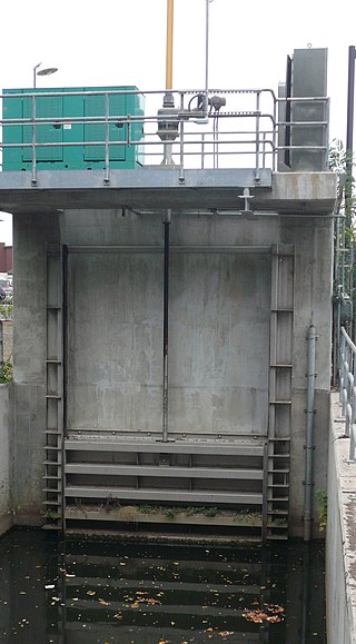
A sluice is a water channel containing a sluice gate, a type of lock to manage the water flow and water level. It can also be an open channel which processes material, such as a river sluice used in gold prospecting or fossicking. A mill race, leet, flume, penstock or lade is a sluice channeling water toward a water mill. The terms sluice, sluice gate, knife gate, and slide gate are used interchangeably in the water and wastewater control industry.

Guyana is divided into 10 regions:
Bow Back Rivers or Stratford Back Rivers is a complex of waterways between Bow and Stratford in east London, England, which connect the River Lea to the River Thames. Starting in the twelfth century, works were carried out to drain Stratford Marshes and several of the waterways were constructed to power watermills. Bow Creek provided the final outfall to the Thames, and the other channels were called Abbey Creek, Channelsea River, City Mill River, Prescott Channel, Pudding Mill River, Saint Thomas Creek, Three Mills Back River, Three Mills Wall River and Waterworks River.
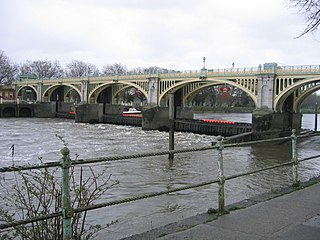
Richmond Lock and Footbridge is a lock, rising and falling low-tide barrage integrating controlled sluices and pair of pedestrian bridges on the River Thames in southwest London, England, and is a Grade II* listed structure. It is the furthest downstream of the forty-five Thames locks and the only one owned and operated by the Port of London Authority. It was opened in 1894 and is north-west of the centre of Richmond in a semi-urban part of southwest London. Downstream are Syon Park and Kew Gardens on opposite banks. It connects the promenade at Richmond with the neighbouring district of St. Margarets on the west bank during the day and is closed at night to pedestrians – after 19:30 GMT or after 21:30 when BST is in use. At high tide the sluice gates are raised and partly hidden behind metal arches forming twin footbridges.

The Berbice River, located in eastern Guyana, is one of the country's major rivers. It rises in the highlands of the Rupununi region and flows northward for 595 kilometres (370 mi) through dense forests to the coastal plain. The river's tidal limit is between 160 and 320 km (99–199 mi) from the sea.

The Demerara River is a river in eastern Guyana that rises in the central rainforests of the country and flows to the north for 346 kilometres until it reaches the Atlantic Ocean. Georgetown, Guyana's largest seaport and capital, is situated on the east bank of the river's mouth. The river divides Essequibo Islands-West Demerara on the west bank from Demerara-Mahaica to the east.
The Torani Canal in northeastern Guyana serves to move water from the Berbice River into the Canje River. It was to serve as irrigation for the sugar industry, and subsequently the rice industry.

The Demerara Harbour Bridge is a 6,074-foot (1,851 m) long floating toll bridge. It was commissioned on 2 July 1978. The bridge crosses the Demerara River 4 miles (6.4 km) south of the Guyanese capital Georgetown, from Peter's Hall, Demerara-Mahaica, East Bank Demerara to Schoon Ord, Essequibo Islands-West Demerara, West Bank Demerara. There is a pedestrian footwalk. A raised section lets small vessels pass under. A retractor span lets large vessels pass.
The Mahaica River is a small river in northern Guyana that drains into the Atlantic Ocean. The village of Mahaica is found at its mouth.

King's Sedgemoor Drain is an artificial drainage channel which diverts the River Cary in Somerset, England along the southern flank of the Polden Hills, to discharge into the River Parrett at Dunball near Bridgwater. As the name suggests, the channel is used to help drain the peat moors of King's Sedgemoor. There was opposition to drainage schemes from the local inhabitants, who feared that they would lose their common grazing rights. However, the main channel was constructed between 1791 and 1795, and despite some defects, brought some relief from flooding to the area.
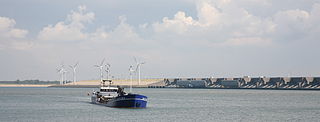
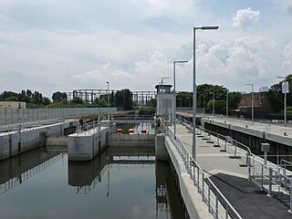
The Haringvlietdam, incorporating the Haringvliet sluices, are hydraulic engineering structures which closed off the estuary of the Haringvliet, Netherlands, as part of the Delta Works. The structure consists of 17 sluices, several kilometres of dam and a shipping lock, and formed the sixth project of the Delta Works.
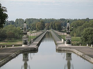
The Briare Aqueduct in central France carries the Canal latéral à la Loire over the river Loire on its journey to the Seine. It replaced a river-level crossing from the canal to meet the Briare Canal that was hazardous in times of flood. Between 1896 and 2003 it was the longest navigable aqueduct in the world, until the opening of the Magdeburg Water Bridge.

The Fens Waterways Link is a project to improve recreational boating opportunities in the counties of Cambridgeshire and Lincolnshire, England. By a combination of improvements to existing waterways and the construction of new links a circular route between Lincoln, Peterborough, Ely and Boston is planned. The project is being organised by the Environment Agency and financed from the Regional Development Agency and the European Union.

Three Mills Wall River Weir is a weir on the Bow Back Rivers, in Mill Meads in the London Borough of Newham, England, near to Three Mills. It was built in 2009, when the Bow Back Rivers were refurbished to make them a key feature of the Queen Elizabeth Olympic Park, and maintains water levels through much of the park in conjunction with the Three Mills Lock and sluice on the Prescott Channel.
Sophia is a ward of Georgetown, the capital of Guyana. It's a predominantly Afro-Guyanese community, and one of Georgetown's poorest neighborhoods.
The East Demerara Water Conservancy (EDWC) is one of Guyana's major water storage and flood control facilities. Over 500,000 residents inhabit the basin that lies below and between the sea wall and the EDWC Dam in a 48 km band from Georgetown to Mahaica. Located in Demerara-Mahaica, the EDWC serves to irrigate thousands of hectares of rice and other crops within this area by storing rain water for dry periods and it also provides one of the primary source of drinking water for the capital city of Georgetown.
The 2005 Georgetown flood was a major flood in and around Georgetown, the capital of Guyana. It started during heavy rains in 2004, and came to a head in January, when sustained heavy rains and high tides over-topped the deteriorating water conservancy. Approximately 290,000 people were affected and the economic impact was estimated to be about US$465 million, or 59% of Guyana's GDP.
Meenkara Dam is an embankment or earthen dam built on the banks of the river Gayatripuzha, a tributary of the river Bharathapuzha, at Muthalamada in the Muthalamada Grama Panchayat near Kollengode in the Palakkad district of Kerala with masonry spillway sections. It is part of the Gayatri Irrigation Project. The project was started in 1956 and partially commissioned in 1960. The project was fully completed in 1964. The irrigation scheme has been prepared for agriculture and drinking water in Palakkad district. Farms in Chittoor, Nemmara, Alathur in Palakkad district and Vadakkancherry in Thrissur district will benefit from this irrigation scheme.
References
- 1 2 GTIMES (2016-06-26). "Residents say Hope Canal is a blessing". Guyana Times. Retrieved 2021-02-01.
- ↑ Chabrol, Denis (2016-06-12). "Hope Canal cost more than publicly stated". Demerara Waves Online News- Guyana. Retrieved 2021-02-01.
- ↑ "Guyana: Tenders for Hope canal structures to be advertised soon - Guyana". ReliefWeb. Retrieved 2021-02-01.
- ↑ Pooran Ballchan- Engineering Student, University of Guyana
- ↑ NDIA Brochure "EDWC Northern Reilef Channel & Associated Works"
- ↑ INEWS (2014-08-29). "GNIC completes construction of Hope Canal sluice doors". INews Guyana. Retrieved 2021-02-01.
- ↑ "Hope Canal project still incomplete". News Room Guyana. 2016-07-01. Retrieved 2021-02-01.
- ↑ "Hope Canal study on the cards". Guyana Chronicle. Retrieved 2021-02-01.