
Lake Ladoga is a freshwater lake located in the Republic of Karelia and Leningrad Oblast in northwestern Russia, in the vicinity of Saint Petersburg.

Lake Constance refers to three bodies of water on the Rhine at the northern foot of the Alps: Upper Lake Constance (Obersee), Lower Lake Constance (Untersee), and a connecting stretch of the Rhine, called the Lake Rhine (Seerhein). These waterbodies lie within the Lake Constance Basin, which is part of the Alpine Foreland and through which the Rhine flows.
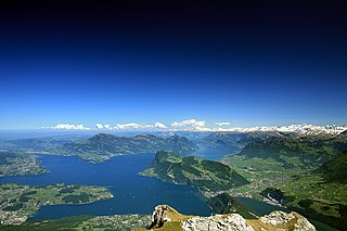
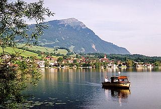
Lake Lucerne is a lake in central Switzerland and the fourth largest in the country.

Lake Neusiedl or Fertő is the largest endorheic lake in Central Europe, straddling the Austrian–Hungarian border. The lake covers 315 km2 (122 sq mi), of which 240 km2 (93 sq mi) is on the Austrian side and 75 km2 (29 sq mi) on the Hungarian side. The lake's drainage basin has an area of about 1,120 km2 (430 sq mi). From north to south, the lake is about 36 km (22 mi) long, and it is between 6 km and 12 km wide from east to west. On average, the lake's surface is 115.45 m (378.8 ft) above the Adriatic Sea and the lake is no more than 1.8 m deep.

Lake Ossiach is a lake in the Austrian state of Carinthia. It is the state's third largest lake, superseded only by Lake Wörth and Lake Millstatt.

Lake Narach is a lake in north-western Belarus, located in the basin of the Viliya river. It is the largest lake in Belarus.

Lake Starnberg, or Starnberger See[ˈʃtaʁnbɛʁɡɐ ˌzeː](listen)) — called Lake Würm, or Würmsee[ˈvʏʁmˌzeː], until 1962 — is Germany's second-largest body of fresh water, having great depth, and fifth-largest lake by area. It and its surroundings lie in three different Bavarian districts, or Landkreise. The lake is property of the state and accordingly managed by the Bavarian Administration of State-Owned Palaces, Gardens and Lakes.
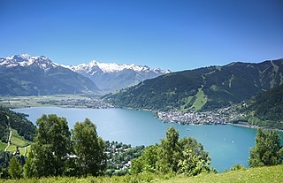
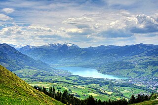
Zell am See is the administrative capital of the Zell am See District in the Austrian state of Salzburg. The town is an important tourist destination known as Zell am See-Kaprun and is a transportation hub for the region.

The Schluchsee is a reservoir lake in the district of Breisgau-Hochschwarzwald, southeast of the Titisee in the Black Forest near Freiburg im Breisgau, Germany.
The Dümmer or officially Dümmer See is a large lake in southern Lower Saxony (Germany). It has a surface of 13.5 km² and an average depth of one metre. Its elevation is 37 metres.

The Sacrower See is a German lake in the northern part of Potsdam in the State of Brandenburg.
Lake Sarnen is a lake in the Swiss canton of Obwalden. The lake is on the Sarner Aa, which flows out of the Lake Lungern, through the Lake Sarnen, and into Lake Lucerne. The municipalities of Sarnen and Sachseln are located on the shores of the lake, and the Brünig railway line follows the eastern shore.

Plauer See (help·info) is a lake in Mecklenburg-Vorpommern, Germany, located at 53°27′57″N12°18′27″E. Its surface is approximately 38.4 km2 and its maximum depth is 25.5 metres (84 ft).

The Großer Plöner See or Lake Plön is the largest lake (30 km²) in Schleswig-Holstein, Germany. It is located near the town of Plön. Its main tributary, as well as its main outflow, is the River Schwentine.
Lake Lauerz is a lake in the Canton of Schwyz, Switzerland. Its water area varies between 310 ha and 360 ha, a maximum depth of 14 m (45.9 ft), and a water level elevation above sea level of 447 m (1,466.5 ft).

Germany is a country in west-central Europe, that stretches from the Alps, across the North European Plain to the North Sea and the Baltic Sea. Germany has the second largest population in Europe and is seventh largest in area. The territory of Germany covers 357,021 km2 (137,847 sq mi), consisting of 349,223 km2 (134,836 sq mi) of land and 7,798 km2 (3,011 sq mi) of waters.

The Alfsee is a reservoir in the north of the district of Osnabrück in the state of Lower Saxony in north Germany. It has an area of 2.2 km².

Keutschacher See is a lake of Carinthia, Austria. It is sixth-largest in Carinthia, with an area of 1.32 km2 (0.51 sq mi). It has a Neolithic stilt settlement, discovered by Ferdinand von Hochstetter in 1864.

The Untersee, also known as Lower Lake Constance, is the smaller of the two lakes that together form Lake Constance and forms part of the boundary between Switzerland and Germany.

The Blausteinsee Leisure and Recreation Area is an artificial lake north of the Eschweiler municipality in the Aachen district of North Rhine-Westphalia, Germany. Its area is around 100 hectares and depth is 46m. It was created during the regeneration of the Zukunft opencast coal mine in the Rhineland coalfield, made by flooding the pit left by the mine with water. Today, the lake is a holiday area for the surrounding towns. The surface of the lake is 129 metres above sea level and its volume is around 25 million cubic metres. The filling of the lake began in 1994.


