
Rhineland-Palatinate is a western state of Germany. It covers 19,846 km2 (7,663 sq mi) and has about 4.05 million residents. It is the ninth largest and sixth most populous of the sixteen states. Mainz is the capital and largest city. Other cities are Ludwigshafen am Rhein, Koblenz, Trier, Kaiserslautern, Worms and Neuwied. It is bordered by North Rhine-Westphalia, Saarland, Baden-Württemberg and Hesse and by the countries France, Luxembourg and Belgium.

The Palatinate is a region of Germany. In the Middle Ages it was known as the Rhenish Palatinate (Rheinpfalz) and Lower Palatinate (Unterpfalz), which strictly speaking designated only the western part of the Electorate of the Palatinate, as opposed to the Upper Palatinate (Oberpfalz). It occupies roughly the southernmost quarter of the German federal state of Rhineland-Palatinate (Rheinland-Pfalz), covering an area of 2,105 square miles (5,450 km2) with about 1.4 million inhabitants. Its residents are known as Palatines (Pfälzer).
The Rhineland is a loosely defined area of Western Germany along the Rhine, chiefly its middle section.

The Moselle is a river that rises in the Vosges mountains and flows through north-eastern France and Luxembourg to western Germany. It is a left bank tributary of the Rhine, which it joins at Koblenz. A small part of Belgium is in its basin as it includes the Sauer and the Our.
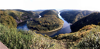
The Saar is a river in northeastern France and western Germany, and a right tributary of the Moselle. It rises in the Vosges mountains on the border of Alsace and Lorraine and flows northwards into the Moselle near Trier. It has two headstreams, that both start near Mont Donon, the highest peak of the northern Vosges. After 246 kilometres (153 mi) the Saar flows into the Moselle at Konz (Rhineland-Palatinate) between Trier and the Luxembourg border. It has a catchment area of 7,431 square kilometres (2,869 sq mi).

The Nahe is a river in Rhineland-Palatinate and Saarland, Germany, a left tributary to the Rhine. It has also given name to the wine region Nahe situated around it.

Moselle Franconian is a West Central German language, part of the Central Franconian languages area, that includes Luxembourgish. It is spoken in the southern Rhineland and along the course of the Moselle, in the Siegerland of North Rhine-Westphalia, throughout western Rhineland-Palatinate and Saarland, Luxembourg, the south of the German-speaking Community of Belgium and in the neighboring French département of Moselle. The Transylvanian Saxon dialect spoken in the Transylvania region of Romania is derived from this dialect as a result of the emigration of numerous "Transylvanian Saxons" between 1100 and 1300, primarily from areas in which the Moselle Franconian dialect was then spoken. Another variety of Moselle Franconian, the Hunsrik, is spoken in some rural areas of southern Brazil, brought by 19th century immigrants from the Hunsrück region in modern Germany.
The Kyll, noted by the Roman poet Ausonius as Celbis, is a 128-kilometre-long (80 mi) river in western Germany, left tributary of the Moselle. It rises in the Eifel mountains, near the border with Belgium and flows generally south through the towns Stadtkyll, Gerolstein, Kyllburg and east of Bitburg. It flows into the Moselle in Ehrang, a suburb of Trier.

Rhenish Franconian or Rhine Franconian is a dialect chain of West Central German. It comprises the varieties of German spoken across the western regions of the states of Saarland, Rhineland-Palatinate, northwest Baden-Württemberg, and Hesse in Germany. It is also spoken in northeast France, in the eastern part of the département of Moselle in the Lorraine region, and in the north-west part of Bas-Rhin in Alsace. To the north, it is bounded by the Sankt Goar line which separates it from Moselle Franconian; to the south, it is bounded by the Main line which is also referred to as the Speyer line which separates it from the Upper German dialects.
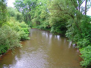
The Schwarzbach is a river in southwestern Germany, left tributary of the Blies. Its source is in the Palatinate Forest, near Trippstadt. It flows through the states Rhineland-Palatinate and Saarland. Towns along its course are Waldfischbach-Burgalben, Contwig and Zweibrücken. After 50 km (31 mi), it flows into the Blies in Homburg-Einöd.
Schwarzbach is a German name meaning "dark stream."

The Lauter is a river in Germany and France.

Nittel, on the Upper Moselle, is an ortsgemeinde in the Landkreis [county] of Trier-Saarburg in the state of Rhineland-Palatinate. It belongs to the Verbandsgemeinde [United Municipalities] of Konz. The place, located between dolomite and limestone cliffs, is a nationally recognized resort.
Haspelschiedt is a commune in the Moselle department of the Grand Est administrative region in north-eastern France. The population in 2018 was 301 inhabitants.

The Alf is a small river in Rhineland-Palatinate, Germany, a left tributary of the Moselle. It rises in the Eifel, near Darscheid, east of Daun. The Alf flows south through Mehren, Gillenfeld and Bausendorf, where it turns east to flow into the Moselle at the village of Alf.

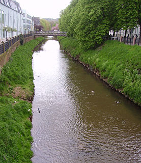
The Lieser is a small river in Rhineland-Palatinate, Germany, a left tributary of the Moselle. It rises in the Eifel, near Boxberg, north of Daun. The Lieser flows south through Daun, Manderscheid and Wittlich. It flows into the Moselle west of the village of Lieser.

The Palatine Watershed forms the main drainage divide in the Palatinate between the Upper Rhine and the Middle Rhine, the two successive sections of the river Rhine that flow through the German state of Rhineland-Palatinate.

The Pays de Bitche is a natural region located in the Moselle department of the Grand Est region of France. It corresponds to the present French part of the former principality of Zweibrücken-Bitsch and to the part of the Northern Vosges that lies within Lorraine.

The Saargau was a Frankish Gau county (Gaugrafschaft). Today the name is given to the ridge between the rivers Saar and Moselle in Germany and, in the south, the region between the Saar and the French border.

