
Sanquhar Castle, now a ruin, was built in the 13th century; the ruins are situated north east of Dumfries overlooking the River Nith. Situated on the southern approach to the former royal burgh of Sanquhar in Dumfries and Galloway, south west Scotland, it sits on the trail of the Southern Upland Way. The castle is a stronghold bounded on the west by the River Nith, to the north by a burn, and made strong by a deep ditch running the remainder of the boundary.

Hawthornden Castle is located on the River North Esk in Midlothian, Scotland. The castle lies a mile to the east of Roslin at grid reference NT287637, and is just downstream from Roslin Castle. Hawthornden comprises a 15th-century ruin, with a 17th-century L-plan house attached. The house has been restored and now serves as a writer's retreat. Man-made caves in the rock beneath the castle have been in use for much longer than the castle itself.

Fatlips Castle is a peel tower in Roxburghshire, in the Scottish Borders. Situated at the top of Minto Crags, above the River Teviot, it was built in the 16th century by the Turnbulls of Barnhills, notorious Border reivers, and owners of nearby Barnhills Tower and farm. In 1545, during the War of the Rough Wooing, the Earl of Hertford burned "Mantoncrake", or Mynto Crag.

Craiglockhart Castle is a ruined tower house in the Craiglockhart district of Edinburgh, Scotland.

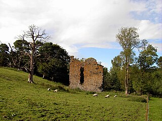
Dryhope Tower is a ruined Scottish peel tower in the valley of the Yarrow Water, in the historic county of Selkirkshire, now part of the Scottish Borders. It lies approximately equidistant between the burghs of Moffat and Selkirk, and defended the north eastern end of St Mary's Loch. The site itself was protected on two sides, to the east by the Dryhope Burn and to the west by the Kirkstead Burn.

Lincluden Collegiate Church, known earlier as Lincluden Priory or Lincluden Abbey, is a ruined religious house, situated in the historic county of Dumfries to the north of the Royal Burgh of Dumfries, Scotland. Situated in a bend of the River Cairn, at its confluence with the River Nith, the ruins are on the site of the Bailey of the very early Lincluden Castle, as are those of the later Lincluden Tower. This religious house was founded circa 1160 and was used for various purposes, until its abandonment around 1700. The remaining ruins are protected as a scheduled monument.
Nether Horsburgh Castle is a ruined tower house near Cardrona, in the Scottish Borders, in the former county of Peebleshire. It is situated at the back of a farmstead, 3.5 miles (5.6 km) southwest of the market town of Peebles, at grid reference grid reference NT304396, on the A72 road. Access may be gained by permission from the adjoining farmstead, Nether Horsburgh Farm.
Timpendean Tower (tim-pen-deen) or Typenden Castle as it was once known, is a ruined 15th-century tower house near Lanton, around 1.5 miles (2.4 km) north-west of Jedburgh in the Scottish Borders.

Bonkyl Church is a Church of Scotland kirk situated at grid reference NT808595 5 miles northeast of Duns in the old county of Berwickshire. The nearest hamlet is Preston just over 2 miles to the south-west.

Kailzie Gardens is a walled garden near Kirkburn in the Scottish Borders area of Scotland, in the Tweed valley, 2.5 miles (4 km) east of Peebles, off the B7062.
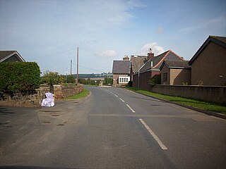
Dryhope is a village in the Scottish Borders area of Scotland, by St. Mary's Loch, on the A708. Known for its rolling green hills and ample walking paths. Also home of St Mary's Loch, the largest natural loch in the Scottish Borders.

Legerwood is a village by the Eden Water, in the Scottish Borders area of Scotland, near Lauder, near the Southern Upland Way.
Kirkburn is a village on the B7062, close to Peebles and the River Tweed, in the Scottish Borders area of Scotland, at the edge of the Cardrona Forest.
Eckford is a small village located between the larger towns of Kelso and Jedburgh in the Scottish Borders. The village is in close proximity to both the River Teviot and its tributary the Kale Water, and the A698 and the B6401 which run approximately parallel to the respective rivers.

Buckholm is a farm near to the A7, in the Scottish Borders, Galashiels area of Scotland.

Liddel Castle is a ruined castle in Liddesdale, by the Liddel Water, near Castleton in the Scottish Borders area of Scotland, in the former county of Roxburghshire. Liddel Castle is a scheduled monument.

Cranshaws is a village on the B6355 road, near Duns, in the Scottish Borders area of Scotland, in the former Berwickshire.
Darnhall Mains is a farm and settlement off the A703, near Eddleston and the Eddleston Water in the Scottish Borders area of Scotland, in the former Peeblesshire.

Drochil Castle is a ruined castle in the Scottish Borders. It is located above the Lyne Water, 10 kilometres (6.2 mi) north-west of Peebles, and 8 kilometres (5.0 mi) south of West Linton.

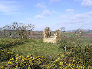
Corsbie Castle is a ruined 16th-century tower house, about 2.5 miles (4.0 km) west of Gordon, Scottish Borders, Scotland, and north of the Eden Water. It was also known as Corsbie Tower. It has been designated as a scheduled monument.
