
Bowen Island, British Columbia, is an island municipality that is part of Metro Vancouver, and within the jurisdiction of the Islands Trust. Located in Howe Sound, it is approximately 6 kilometres (3.7 mi) wide by 12 kilometres (7.5 mi) long, and at its closest point is about 3 kilometres (1.9 mi) west of the mainland. There is regular ferry service from Horseshoe Bay provided by BC Ferries, and semi-regular water taxi services. The population of 4,256 is supplemented in the summer by about 1,500 visitors. It has a land area of 50.12 km2 (19.35 sq mi).
British Columbia Ferry Services Inc., operating as BC Ferries (BCF), is a former provincial Crown corporation, now operating as an independently managed, publicly owned Canadian company. BC Ferries provides all major passenger and vehicle ferry services for coastal and island communities in the Canadian province of British Columbia. Set up in 1960 to provide a similar service to that provided by the Black Ball Line and the Canadian Pacific Railway, which were affected by job action at the time, BC Ferries has become the largest passenger ferry line in North America, operating a fleet of 41 vessels with a total passenger and crew capacity of over 27,000, serving 47 locations on the B.C. coast.

West Vancouver is a district municipality in the province of British Columbia, Canada. A member municipality of the Metro Vancouver Regional District, West Vancouver is to the northwest of the city of Vancouver on the northern side of English Bay and the southeast shore of Howe Sound, and is adjoined by the District of North Vancouver to its east. Together with the District of North Vancouver and the City of North Vancouver, it is part of a local regional grouping referred to as the North Shore municipalities, or simply "the North Shore".
British Columbia Highway 101, also known as the Sunshine Coast Highway, is a 156 kilometres (97 mi) long highway that is the main north–south thoroughfare on the Sunshine Coast in British Columbia, Canada.
The North Shore of Burrard Inlet is a term commonly used to refer to several areas adjacent to Vancouver, British Columbia, Canada:

Porteau Cove Provincial Park is a provincial park located along the eastern shore of Howe Sound in British Columbia, Canada.
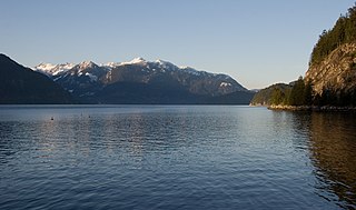
Howe Sound is a roughly triangular sound, that joins a network of fjords situated immediately northwest of Vancouver, British Columbia, Canada. It was designated as a UNESCO Biosphere Reserve in 2021.
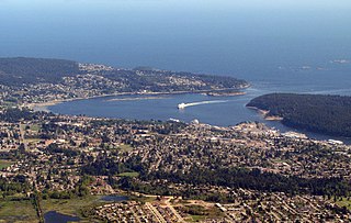
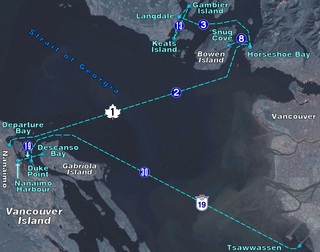
Departure Bay is a bay in central Nanaimo, British Columbia, on the east coast of Vancouver Island. The surrounding neighbourhood is also referred to as "Departure Bay" —once a settlement of its own, it was amalgamated into the City of Nanaimo in the 1970s.

Plumper Cove Marine Provincial Park is a provincial park in British Columbia, Canada. The park is located on the northwest shore of Keats Island in Howe Sound, northwest of Vancouver, British Columbia.
Woodfibre, originally Britannia West, was a pulp mill and at one time a small company town, on the west side of upper Howe Sound near Squamish, British Columbia. The mill closed in March 2006.
Gambier Island is an island located in Howe Sound near Vancouver, British Columbia. It is about 17,049 acres in size and is located about 10 kilometres north of the Horseshoe Bay community and ferry terminal in westernmost West Vancouver.

The Puget Sound Navigation Company (PSNC) was founded by Charles E. Peabody in 1898. Today the company operates an international passenger and vehicle ferry service between Port Angeles, Washington, United States and Victoria, British Columbia, Canada on the MV Coho, through its operating company, Black Ball Ferry Line.

Langdale is a small residential community in British Columbia, Canada, located within the territory of the Squamish Nation, and part of West Howe Sound, Electoral Area F within the Sunshine Coast Regional District (SCRD).
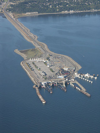
Tsawwassen is a ferry terminal and a major transportation facility in Delta, British Columbia, part of the BC Ferries system and Highway 17. Positioned less than 500 metres (1,600 ft) from the 49th parallel along the Canada–United States border, it is located at the southwestern end of a 2-kilometre (1.2 mi) causeway that juts out into the Strait of Georgia off the mainland at the community of Tsawwassen. With an approximate size of 23 hectares, it is the largest ferry terminal in North America.

Active Pass is a strait separating Galiano Island in the north and Mayne Island in the south in the southern Gulf Islands, British Columbia, Canada. It connects the Trincomali Channel in the west and the Strait of Georgia in the east. The pass stretches 5.5 km from northeast to southwest with two roughly right-angle bends, one at each end.

Keats Island is an inhabited island located in Howe Sound near Vancouver, British Columbia. Most people who spend time on the island are visitors to one of the camps or the Marine Park, or owners of seasonal cottages.

Victoria Harbour is a harbour, seaport, and seaplane airport in the Canadian city of Victoria, British Columbia. It serves as a cruise ship and ferry destination for tourists and visitors to the city and Vancouver Island. It is both a port of entry and an airport of entry for general aviation. Historically it was a shipbuilding and commercial fishing centre. While the Inner Harbour is fully within the City of Victoria, separating the city's downtown on its east side from the Victoria West neighbourhood, the Upper Harbour serves as the boundary between the City of Victoria and the district municipality of Esquimalt. The inner reaches are also bordered by the district of Saanich and the town of View Royal. Victoria is a federal "public harbour" as defined by Transport Canada. Several port facilities in the harbour are overseen and developed by the Greater Victoria Harbour Authority, however the harbour master's position is with Transport Canada.

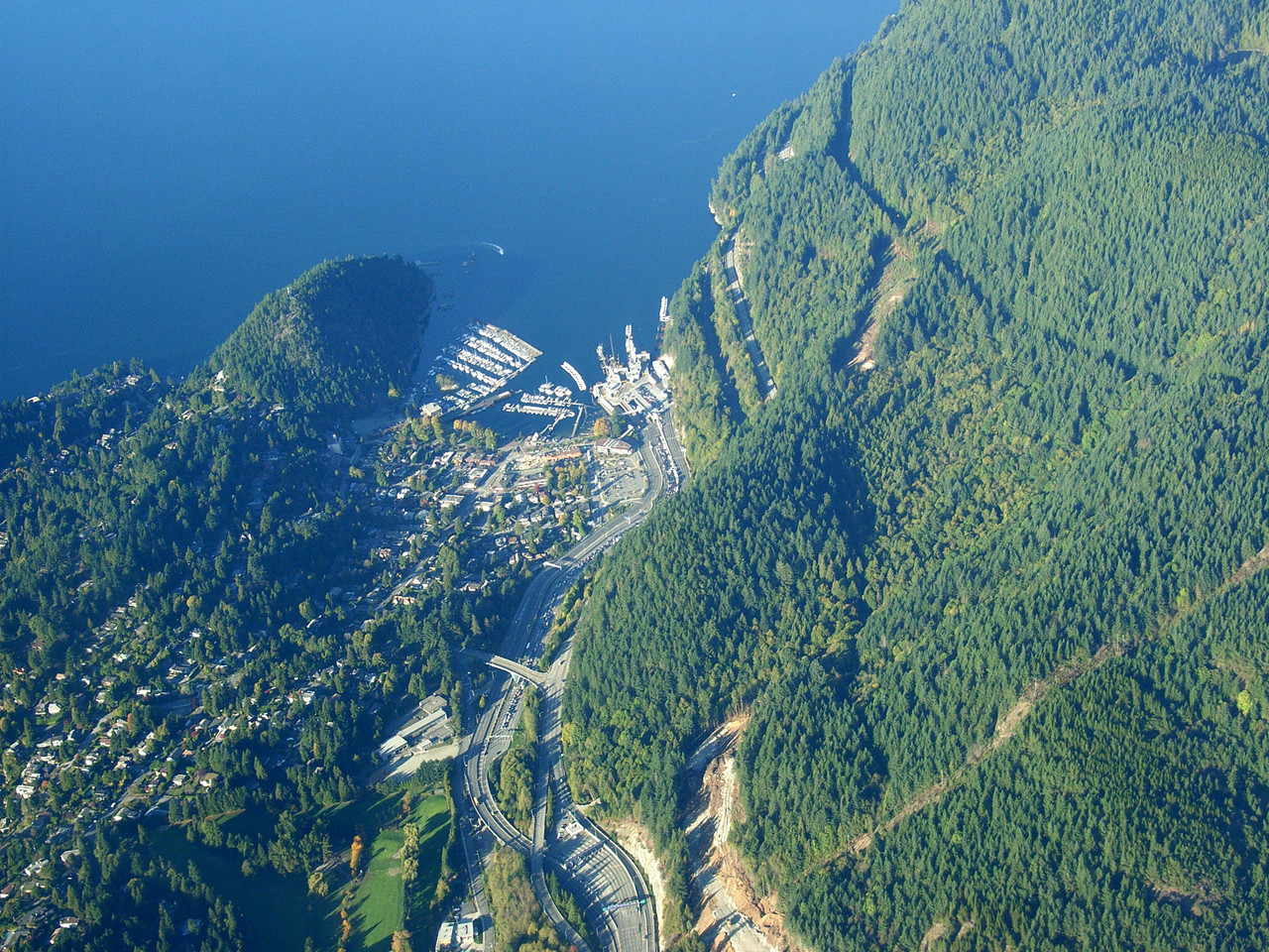
Horseshoe Bay is a major ferry terminal owned and operated by BC Ferries in British Columbia, Canada. Located in the community of Horseshoe Bay, a neighbourhood of West Vancouver, the terminal provides a vehicle ferry link from the Lower Mainland to Vancouver Island, the Sunshine Coast, and to Bowen Island, a small island in the southern part of Howe Sound.
The Bowen Island ferry travels between Snug Cove on Bowen Island, and Horseshoe Bay in the District of West Vancouver, British Columbia, Canada, a trip of three nautical miles across Queen Charlotte Channel. A scheduled ferry has been in operation since 1921, when Bowen Island was a popular holiday destination. Prior to that year, transportation to the island was by steamship from Vancouver, with only one trip daily. The Bowen Island ferry used a fleet of small passenger vessels until 1956, when a single car ferry began passenger service, and that ferry began carrying vehicles in 1958. In 2022 the route carried in excess of 1.2 million passengers plus 570,000 vehicles.
Langdale is a ferry terminal owned and operated by BC Ferries, which provides ferry services from the Sunshine Coast to the Lower Mainland, Gambier Island, and Keats Island in the Canadian province of British Columbia.


