
Entre Ríos is a central province of Argentina, located in the Mesopotamia region. It borders the provinces of Buenos Aires (south), Corrientes (north) and Santa Fe (west), and Uruguay in the east.

Rosario is the largest city in the central Argentina province of Santa Fe. The city is located 300 km (186 mi) northwest of Buenos Aires, on the west bank of the Paraná River. Rosario is the third most populous city in the country, and is also the most populous city in Argentina that is not a capital(provincial or national). With a growing and important metropolitan area, Greater Rosario has an estimated population of 1,700,000 as of 2020.. One of its main attractions includes the neoclassical, Art Nouveau, and Art Deco architecture that has been retained over the centuries in hundreds of residences, houses and public buildings.

Villa Constitución is a city in the province of Santa Fe, Argentina, and the head town of the Constitución Department. It is located on the south-western banks of the Paraná River between the courses of the Arroyo Pavón and the Arroyo del Medio, about 214 km south from the provincial capital, the city of Santa Fe, and 50 km from Rosario. It has a population of more than 47,374 inhabitants as per the 2010 census [INDEC].

Greater Rosario is the metropolitan area of the city of Rosario, in the province of Santa Fe, Argentina. This metropolis has a population of about 1.3 million thus being Argentina's third most populated urban settlement, after Buenos Aires and Córdoba.

Granadero Baigorria is a city in the south of the province of Santa Fe, Argentina, located directly north of Rosario, on the western shore of the Paraná River, and forming part of the Greater Rosario metropolitan area. Its population is about 43,000 inhabitants (2015).

The Ludueña Stream is a small river in the province of Santa Fe, Argentina, which starts near the city of Rosario and flows through it, mostly east-southwards, ending in the Paraná River in the neighbourhood commonly known as Arroyito, near Rosario Central's football stadium.
Funes is a small city in the province of Santa Fe, Argentina, located within the metropolitan area of Greater Rosario, about 15 km west from downtown Rosario. It has a population of about 23,500 inhabitants.

This article is about the geography and urban structure of Rosario, which is the largest city of the province of Santa Fe, Argentina, and the third most populous in the country, after Córdoba and Buenos Aires. It is located about 300 km (190 mi) north of Buenos Aires, on the Western shore of the Paraná River, and it has about 910,000 inhabitants. It is surrounded by smaller cities and towns that form a metropolitan area with a population of about 1.2 million according to the 2001 census [INDEC].

The Port of Rosario is an inland port and a major goods-shipping center of Argentina, located in the city of Rosario, province of Santa Fe, on the western shore of the Paraná River, about 550 km upstream from the Atlantic Ocean.
Oliveros is a town in the province of Santa Fe, Argentina. The municipality has 4,750 inhabitants and is classed as a comuna. It is located in the Iriondo Department, 126 km south from the capital of the province.

The Hospital Provincial de Rosario is a general hospital in Rosario, Argentina, which depends on the Health Ministry of the provincial state of Santa Fe. It is a public hospital and serves as the base hospital for Programmatic Area III of Zone VIII of the Santa Fe Ministry of Health.

Pellegrini Avenue is a street in Rosario, Santa Fe Province, Argentina. It is a two-way avenue that runs east–west through the center-south of the city, from the coastal avenue by the Paraná River to the western limit of the urbanized area. Together with the river and with Oroño Boulevard, it also marks the unofficial limit of the downtown area.

Carlos Pellegrini is a town in the center-west of Santa Fe Province, Argentina.
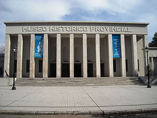
The Dr. Julio Marc Provincial Historical Museum is a museum in Rosario, Argentina. It comprises more than 30 rooms hosting collections of archaeological items, Spanish-American art, numismatics, pre-Columbian textile and silverwork crafts, and weapons, complemented by archives, a library, and collections of historical newspapers and maps.

Sunchales is a city in the province of Santa Fe, Argentina. It has 21,304 inhabitants per the 2010 census [INDEC]. It lies in the center-west of the province, 135 km (84 mi) from the provincial capital Santa Fe, on National Route 34.
Ibarlucea is a town (comuna) in the province of Santa Fe, Argentina. It has 2,549 inhabitants per the 2001 census [INDEC]. It is located on National Route 34, immediately north-west of Rosario, forming part of the Greater Rosario metropolitan area, and 155 km (96 mi) south of the provincial capital Santa Fe.

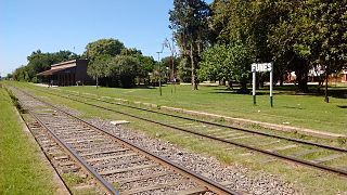
Patio Parada is a rail yard in Rosario, province of Santa Fe, Argentina. It is an important part of the railway system of the city and has been designed as the future site of a multi-modal public transport terminus. Formerly belonging to the Ferrocarril General Bartolomé Mitre company, it is now managed by the Nuevo Central Argentino (NCA) railway company. It employs a broad 5 ft 6 in (1676 mm) gauge railway.

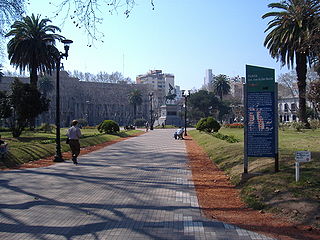
Plaza 25 de Mayo is a plaza in Rosario, province of Santa Fe, Argentina. It is Rosario's civic center, and the core of the original settlement. Its name alludes to the date of the May Revolution, which led to the establishment of the first local Argentine government in Buenos Aires. Before 1852, when this name was adopted, it was simply called Plaza Principal.
Plaza San Martín is a plaza in Rosario, province of Santa Fe, Argentina. Its name is an homage to General José de San Martín, hero of the Argentine War of Independence.

The Clemente Álvarez Emergency Hospital is an emergency hospital and trauma center in Rosario, province of Santa Fe, Argentina. It is located on the 3200 block of Pellegrini Avenue, west of the city center.
