
Adventures of Huckleberry Finn is a picaresque novel by American author Mark Twain that was first published in the United Kingdom in December 1884 and in the United States in February 1885.

Yellowstone Caldera, also known as the Yellowstone Plateau Volcanic Field, is a Quaternary caldera complex and volcanic plateau spanning parts of Wyoming, Idaho, and Montana. It is driven by the Yellowstone hotspot and is largely within Yellowstone National Park. The field comprises four overlapping calderas, multiple lava domes, resurgent domes, crater lakes, and numerous bimodal lava flows and tuff layers of basaltic and rhyolitic composition, originally covering about 17,000 km2 (6,600 sq mi).

The Chenango River is a 90-mile-long (140 km) tributary of the Susquehanna River in central New York in the United States. It drains a dissected plateau area in upstate New York at the northern end of the Susquehanna watershed.

The West Branch Delaware River is one of two branches that form the Delaware River. It is approximately 90 mi (144 km) long, and flows through the U.S. states of New York and Pennsylvania. It winds through a mountainous area of New York in the western Catskill Mountains for most of its course, before joining the East Branch along the northeast border of Pennsylvania with New York. Midway or so it is empounded by the Cannonsville Dam to form the Cannonsville Reservoir, both part of the New York City water supply system for delivering drinking water to the City.

The Sacandaga River is a 64-mile-long (103 km) river in the northern part of New York in the United States. Its name comes from the Native American Sa-chen-da'-ga, meaning "overflowed lands".

The Huckleberry Railroad is a 3 ft narrow gauge heritage railroad located in Genesee Township, Michigan, near Flint. The railroad operates alongside Crossroads Village, both of which are owned and maintained by the Genesee County Parks and Recreation Commission.

Stony Clove Creek is a 10.3-mile-long (16.6 km) creek in the Catskill Mountains in New York. It is a tributary of Esopus Creek, which in turn is a tributary of the Hudson River. It joins the Esopus in the village of Phoenicia, and has two smaller tributaries up north of Phoenicia.

The Yellowstone Plateau Volcanic Field, also known as the Yellowstone Supervolcano or the Yellowstone Volcano, is a complex volcano, volcanic plateau and volcanic field located mostly in the western U.S. state of Wyoming, but it also stretches into Idaho and Montana. It is a popular site for tourists.
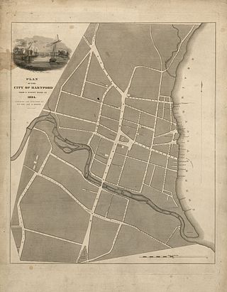
The Park River is a tributary of the Connecticut River in Hartford, Connecticut. It was officially named the Park River in 1892 after Bushnell Park, through which it flowed in downtown Hartford. A local newspaper had advocated for that name rather than the “’Hog River’” name which was then in use. Between 1940 and the 1980s, the 2.3-mile (3.7 km) river was buried by the Army Corps of Engineers to prevent the spring floods regularly caused by increased surface runoff from urban development.

Mill Creek Falls, is a waterfall located in the Rogue River Canyon within the Prospect State Scenic Viewpoint in Jackson County, in the U.S. state of Oregon. The waterfall is located at the south end of Mill Creek as it plunges into the Rogue River over a carved cliff surrounded by walls of petrified volcanic ash consequence of Mount Mazama eruption.

Gaylussacia brachycera, commonly known as box huckleberry or box-leaved whortleberry, is a low North American shrub related to the blueberry and the other huckleberries. It is native to the east-central United States.

Huckleberry "Huck" Finn is a fictional character created by Mark Twain who first appeared in the book The Adventures of Tom Sawyer (1876) and is the protagonist and narrator of its sequel, Adventures of Huckleberry Finn (1884). He is 12 to 13 years old during the former and a year older at the time of the latter. Huck also narrates Tom Sawyer Abroad and Tom Sawyer, Detective, two shorter sequels to the first two books.

The Titicus River is an 8.5-mile-long (13.7 km) river in southwestern Connecticut and southeastern New York that drains into the Titicus Reservoir, part of New York City's water supply system. Part of both the Croton River watershed and the system's Croton Watershed, has a 23.8 square miles (62 km2) drainage area. It is one of the few rivers with headwaters in Connecticut that is part of the system. The source of the river is in Ridgefield, Connecticut. About one mile down stream, the stream marks the southern boundary of the Kiahs Brook Reserve. Another 0.5 miles downriver, it joins with Kiahs Brook, and then runs fairly close to Route 116. Once past the New York border, the Titicus River still runs close to New York 116 until emptying into the Titicus Reservoir. After the Titicus Reservoir, it runs another 0.5 miles, under I-684, and drains into the Muscoot Reservoir.
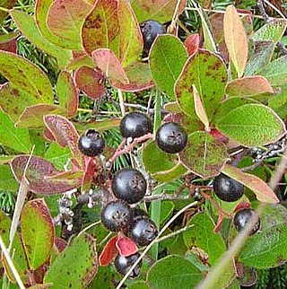
Huckleberry is a name used in North America for several plants in the family Ericaceae, in two closely related genera: Vaccinium and Gaylussacia.

The Undergraduate Student Government (USG) at Stony Brook University is a governing body representing the undergraduate students of Stony Brook University. As with most student governments in the United States, one of USG's main functions is to recognize, fund and regulate student organizations. The USG is composed of an executive, a legislative, and a judicial branch. Along with the Graduate Student Organization, USG is the only other organization authorized to distribute the Student Activity Fee (SAF) in a viewpoint-neutral manner. In accordance with State University of New York Policies and Procedures, the mandatory SAF provides the USG with an annual budget of approximately $3.1 million, independently of the state budget.
West Branch Fishing Creek is one of the northernmost major tributaries of Fishing Creek in Sullivan County, Pennsylvania and Columbia County, Pennsylvania, in the United States. It is 11.1 miles (17.9 km) long and flows through Davidson Township, Sullivan County and Sugarloaf Township, Columbia County. The creek's watershed has an area of 33.5 square miles, nearly all of which is forested land.

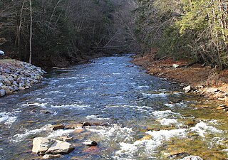
Trout Brook, also called Ball Brook, is a cold water tributary of the Quinapoxet River located in Holden, Massachusetts. Trout Brook is stocked with trout each spring by the Massachusetts Fisheries and Wildlife Division. As the Quinapoxet River is part of the water supply for Worcester, Massachusetts, both the Quinapoxet and all of its major tributaries including Trout Brook are monitored by the USGS for water quality.
Arden is an unincorporated community in Stevens County, Washington, United States.
Charlotte Creek is a river located in Delaware County, New York. Charlotte Creek borders the southern border of Otsego County, New York for a few miles near the mouth. The creek converges with the Susquehanna River by Emmons, New York.

Bowmans Creek is a river in Montgomery County, New York. It begins west of the hamlet of Hessville and just south of the hamlet of Ripple Corners. It then flows in a mostly southeast direction for a few miles passing through the hamlet of Sprout Brook before flowing into the Canajoharie Creek just east of the hamlet of Sprout Brook.
