The Continental Divide of the Americas is the principal, and largely mountainous, hydrological divide of the Americas. The Continental Divide extends from the Bering Strait to the Strait of Magellan, and separates the watersheds that drain into the Pacific Ocean from those river systems that drain into the Atlantic and Arctic oceans.

Lake Bonneville was the largest Late Pleistocene paleolake in the Great Basin of western North America. It was a pluvial lake that formed in response to an increase in precipitation and a decrease in evaporation as a result of cooler temperatures. The lake covered much of what is now western Utah and at its highest level extended into present-day Idaho and Nevada. Many other hydrographically closed basins in the Great Basin contained expanded lakes during the Late Pleistocene, including Lake Lahontan in northwestern Nevada.

The Interior Plains is a vast physiographic region that spreads across the Laurentian craton of central North America, extending along the east flank of the Rocky Mountains from the Gulf Coast region to the Arctic Beaufort Sea. In Canada, it encompasses the Canadian Prairies separating the Canadian Rockies from the Canadian Shield, as well as the Boreal Plains and Taiga Plains east of the Mackenzie and Richardson Mountains; while in the United States, it includes the Great Plains of the West/Midwest and the tallgrass prairie region to the south of the Great Lakes extending east to the Appalachian Plateau region.

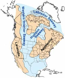
The Western Interior Seaway was a large inland sea that split the continent of North America into two landmasses. The ancient sea, which existed from the early Late Cretaceous to the earliest Paleocene, connected the Gulf of Mexico, through the United States and Canada, to the Arctic Ocean. The two land masses it created were Laramidia to the west and Appalachia to the east. At its largest extent, it was 2,500 feet (760 m) deep, 600 miles (970 km) wide and over 2,000 miles (3,200 km) long.
The Late Cretaceous is the younger of two epochs into which the Cretaceous Period is divided in the geologic time scale. Rock strata from this epoch form the Upper Cretaceous Series. The Cretaceous is named after creta, the Latin word for the white limestone known as chalk. The chalk of northern France and the white cliffs of south-eastern England date from the Cretaceous Period.

The Laurentide Ice Sheet was a massive sheet of ice that covered millions of square miles, including most of Canada and a large portion of the Northern United States, multiple times during the Quaternary glacial epochs, from 2.58 million years ago to the present.

The Appalachian Plateau is a series of rugged dissected plateaus located on the western side of the Appalachian Mountains. The Appalachian Mountains are a mountain range that run down the Eastern United States.
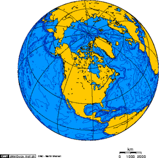
North America is the third largest continent, and is also a portion of the third largest supercontinent if North and South America are combined into the Americas and Africa, Europe, and Asia are considered to be part of one supercontinent called Afro-Eurasia. With an estimated population of 580 million and an area of 24,709,000 km2 (9,540,000 mi2), the northernmost of the two continents of the Western Hemisphere is bounded by the Pacific Ocean on the west; the Atlantic Ocean on the east; the Caribbean Sea on the south; and the Arctic Ocean on the north.

The San Juan Basin is a geologic structural basin located near the Four Corners region of the Southwestern United States. The basin covers 7,500 square miles and resides in northwestern New Mexico, southwestern Colorado, and parts of Utah and Arizona. Specifically, the basin occupies space in the San Juan, Rio Arriba, Sandoval, and McKinley counties in New Mexico, and La Plata and Archuleta counties in Colorado. The basin extends roughly 100 miles (160 km) N-S and 90 miles (140 km) E-W.
The Laurentian Divide also called the Northern Divide and locally the height of land, is a continental divide in central North America that separates the Hudson Bay watershed to the north from the Gulf of Mexico watershed to the south and the Great Lakes-St. Lawrence watershed to the southeast.

The Dakota is a sedimentary geologic unit name of formation and group rank in Midwestern North America. The Dakota units are generally composed of sandstones, mudstones, clays, and shales deposited in the Mid-Cretaceous opening of the Western Interior Seaway. The usage of the name Dakota for this particular Albian-Cenomanian strata is exceptionally widespread; from British Columbia and Alberta to Montana and Wisconsin to Colorado and Kansas to Utah and Arizona. It is famous for producing massive colorful rock formations in the Rocky Mountains and the Great Plains of the United States, and for preserving both dinosaur footprints and early deciduous tree leaves.

The Trans-Hudson orogeny or Trans-Hudsonian orogeny was the major mountain building event (orogeny) that formed the Precambrian Canadian Shield and the North American Craton, forging the initial North American continent. It gave rise to the Trans-Hudson orogen (THO), or Trans-Hudson Orogen Transect (THOT), which is the largest Paleoproterozoic orogenic belt in the world. It consists of a network of belts that were formed by Proterozoic crustal accretion and the collision of pre-existing Archean continents. The event occurred 2.0–1.8 billion years ago.
The geology of Saskatchewan can be divided into two main geological regions, the Precambrian Canadian Shield and the Phanerozoic Western Canadian Sedimentary Basin. Within the Precambrian shield exists the Athabasca sedimentary basin. Meteorite impacts have altered the natural geological formation processes. The prairies were most recently affected by glacial events in the Quaternary period.
The Nikanassin Formation is a stratigraphic unit of Late Jurassic (Portlandian) to Early Cretaceous (Barremian) age. It is present along the western edge of the Western Canada Sedimentary Basin in western Alberta and northeastern British Columbia. Its name was first proposed by D.B. Dowling in 1909 (Coal Fields South of Grand Trunk Pacific Railway, in the foothills of the Rocky Mountain, Alberta Page 140 paragraph 4 " to this it is proposed to give the name Nikanassin, from the Cree word meaning outer range" Also it is noted on the map by D.B. Dowling.(Geological Survey of Canada. Incorrect info follows: It was named by B.R. MacKay in 1929 for the Nikanassin Range of the front-central ranges of the Canadian Rockies. Mackay did not designate a type locality for the formation, although he described outcrops near the hamlet of Brûlé, north of the Yellowhead Highway outside of Jasper National Park.
Colorado is a geologic name applied to certain rocks of Cretaceous age in the North America, particularly in the western Great Plains. This name was originally applied to classify a group of specific marine formations of shale and chalk known for their importance in Eastern Colorado. The surface outcrop of this group produces distinctive landforms bordering the Great Plains and it is a significant feature of the subsurface of the Denver Basin and the Western Canadian Sedimentary Basin. These formations record important sequences of the Western Interior Seaway, and as the geology of this seaway was studied, this name came to be used in states beyond Colorado, but was later replaced in several of these states with more localized names.

The Straight Cliffs Formation is a stratigraphic unit in the Kaiparowits Plateau of south central Utah. It is Late Cretaceous in age and contains fluvial, paralic, and marginal marine (shoreline) siliciclastic strata. It is well exposed around the margin of the Kaiparowits Plateau in the Grand Staircase – Escalante National Monument in south central Utah. The formation is named after the Straight Cliffs, a long band of cliffs creating the topographic feature Fiftymile Mountain.
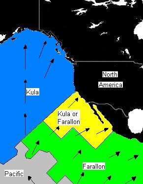
Laramidia was an island continent that existed during the Late Cretaceous period, when the Western Interior Seaway split the continent of North America in two. In the Mesozoic era, Laramidia was an island land mass separated from Appalachia to the east by the Western Interior Seaway. The seaway eventually shrank, split across the Dakotas, and retreated toward the Gulf of Mexico and the Hudson Bay. The masses joined, forming the continent of North America.
During most of the Late Cretaceous the eastern half of North America formed Appalachia, an island land mass separated from Laramidia to the west by the Western Interior Seaway. This seaway had split North America into two massive landmasses due to a multitude of factors such as tectonism and sea-level fluctuations for nearly 40 million years. The seaway eventually expanded, divided across the Dakotas, and by the end of the Cretaceous, it retreated towards the Gulf of Mexico and the Hudson Bay. This left the island masses joined in the continent of North America as the Rocky Mountains rose. From the Cenomanian to the end of the Campanian ages of the Late Cretaceous, Appalachia was separated from the rest of North America. As the Western Interior Seaway retreated in the Maastrichtian, Laramidia and Appalachia eventually connected. Because of this, its fauna was isolated, and developed very differently from the tyrannosaur, ceratopsian, hadrosaurid, pachycephalosaur and ankylosaurid dominated fauna of the western part of North America, known as "Laramidia".
Three Western Interior Seaway anoxic events occurred during the Cretaceous in the shallow inland seaway that divided North America in two island continents, Appalachia and Laramidia. During these anoxic events much of the water column was depleted in dissolved oxygen. While anoxic events impact the world's oceans, Western Interior Seaway anoxic events exhibit a unique paleoenvironment compared to other basins. The notable Cretaceous anoxic events in the Western Interior Seaway mark the boundaries at the Aptian-Albian, Cenomanian-Turonian, and Coniacian-Santonian stages, and are identified as Oceanic Anoxic Events I, II, and III respectively. The episodes of anoxia came about at times when very high sea levels coincided with the nearby Sevier orogeny that affected Laramidia to the west and Caribbean large igneous province to the south, which delivered nutrients and oxygen-adsorbing compounds into the water column.
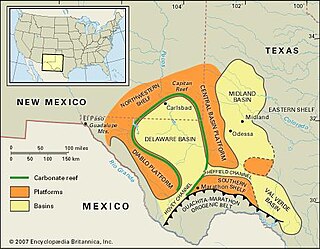
The Val Verde Basin is a marginal foreland basin located in West Texas, just southeast of the Midland Basin. The Val Verde is a sub-basin of the larger Permian Basin and is roughly 24–40 km wide by 240 km long. It is an unconventional system and its sediments were deposited during a long period of flooding during the Middle to Late Cretaceous. This flooding event is referred to as the Western Interior Seaway, and many basins in the Western United States can attribute their oil and gas producing basins to carbonate deposition during this time period.