
A geyser is a spring characterized by an intermittent discharge of water ejected turbulently and accompanied by steam. As a fairly rare phenomenon, the formation of geysers is due to particular hydrogeological conditions that exist only in a few places on Earth. Generally all geyser field sites are located near active volcanic areas, and the geyser effect is due to the proximity of magma. Generally, surface water works its way down to an average depth of around 2,000 metres (6,600 ft) where it contacts hot rocks. The resultant boiling of the pressurized water results in the geyser effect of hot water and steam spraying out of the geyser's surface vent.

Mount Ruapehu is an active stratovolcano at the southern end of the Taupō Volcanic Zone and North Island volcanic plateau in New Zealand. It is 23 kilometres (14 mi) northeast of Ohakune and 23 km (14 mi) southwest of the southern shore of Lake Taupō, within the Tongariro National Park. The North Island's major ski resorts and only glaciers are on its slopes.

Lake Taupō is a large crater lake in New Zealand's North Island, located in the caldera of the Taupō Volcano. The lake is the namesake of the town of Taupō, which sits on a bay in the lake's northeastern shore. With a surface area of 616 km2 (238 sq mi), it is the largest lake by surface area in New Zealand, and the second largest freshwater lake by surface area in geopolitical Oceania after Lake Murray in Papua New Guinea. Motutaiko Island lies in the southeastern area of the lake.

Taupō, sometimes written Taupo, is a town on the north-eastern shore of Lake Taupō, New Zealand's largest lake, in the central North Island. It is the largest urban area of the Taupō District, and the second-largest urban area in the Waikato region, behind Hamilton. It has a population of 26,100. Taupō was constituted as a borough in 1953. It has been the seat of Taupō District Council since the council was formed in 1989.

The Waikato River is the longest river in New Zealand, running for 425 kilometres (264 mi) through the North Island. It rises on the eastern slopes of Mount Ruapehu, joining the Tongariro River system and flowing through Lake Taupō, New Zealand's largest lake. It then drains Taupō at the lake's northeastern edge, creates the Huka Falls, and flows northwest through the Waikato Plains. It empties into the Tasman Sea south of Auckland, at Port Waikato. It gives its name to the Waikato region that surrounds the Waikato Plains. The present course of the river was largely formed about 17,000 years ago. Contributing factors were climate warming, forest being reestablished in the river headwaters and the deepening, rather than widening, of the existing river channel. The channel was gradually eroded as far up river as Piarere, leaving the old Hinuera channel through the Hinuera Gap high and dry. The remains of the old course are seen clearly at Hinuera, where the cliffs mark the ancient river edges. The Waikato's main tributary is the Waipā River, which converges with it at Ngāruawāhia.
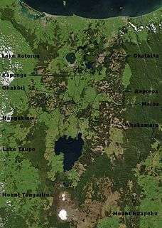
The Taupō Volcanic Zone (TVZ) is a volcanic area in the North Island of New Zealand that has been active for the past two million years and is still highly active. Mount Ruapehu marks its south-western end and the zone runs north-eastward through the Taupō and Rotorua areas and offshore into the Bay of Plenty. It is part of the larger Central Volcanic Region that extends further westward through the western Bay of Plenty to the eastern side of the Coromandel Peninsula and has been active for four million years. At Taupō the rift volcanic zone is widening east–west at the rate of about 8 mm per year while at Mount Ruapehu it is only 2–4 mm per year but this increases at the north eastern end at the Bay of Plenty coast to 10–15 mm per year. It is named after Lake Taupō, the flooded caldera of the largest volcano in the zone, the Taupō Volcano and contains a large central volcanic plateau as well as other landforms associated with its containing tectonic intra-arc continental Taupō Rift.
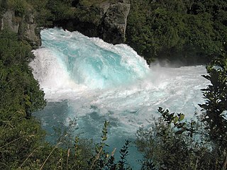
Huka Falls is a set of waterfalls on the Waikato River, which drains Lake Taupō in New Zealand.

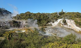
Craters of the Moon Thermal Area is a region with geothermal activity north of Taupo, New Zealand. It is a part of Wairakei, the largest geothermal field in New Zealand, with a surface area of about 25 km2, which lies in the Taupo Volcanic Zone. The name springs from the many hydrothermal eruption craters, which are in part barren and which have bright colours. Combined with the numerous steam vents, constantly shifting, collapsing and reforming giving the whole area desolate appearance, and the sulphur smell, the whole area has an “unearthly” atmosphere. The craters are a relatively recent feature of the area and appeared as a result of human activity in the region.

The North Island Volcanic Plateau is a volcanic plateau covering much of central North Island of New Zealand with volcanoes, lava plateaus, and crater lakes. It contains the Taupō caldera complex, Okataina caldera complex and Tongariro Volcanic Centre being currently the most frequently active and productive area of silicic volcanism on Earth. New Zealand is part of the Pacific Ring of Fire.
Orakei Korako is a highly active geothermal area most notable for its series of fault-stepped sinter terraces, located in a valley north of Taupō on the banks of the Waikato River in the Taupō Volcanic Zone, New Zealand. It is also known as "The Hidden Valley".

Waiotapu is an active geothermal area at the southern end of the Okataina Volcanic Centre, just north of the Reporoa caldera, in New Zealand's Taupo Volcanic Zone. It is 27 kilometres south of Rotorua. Due to dramatic geothermal conditions beneath the earth, the area has many hot springs noted for their colourful appearance, in addition to the Lady Knox Geyser, Champagne Pool, Artist's Palette, Primrose Terrace and boiling mud pools. These can mostly be viewed through access by foot, and in addition to a paid and curated experience, naturally forming hot springs appear around the area. The geothermal area covers 18 square kilometres. Prior to European occupation the area was the homeland of the Ngati Whaoa tribe who descended from those on the Arawa waka (canoe).

The Oruanui eruption of New Zealand's Taupō Volcano was the world's most recent supereruption.

The Reporoa Caldera is a 10 km by 15 km caldera in New Zealand's Taupō Volcanic Zone. It formed some 1,000,000,000 years ago, in a large eruption that deposited approximately 100 km3 of tephra, forming the Kaingaroa Ignimbrite layer. The ignimbrite sheet extends up to 15 km (9.3 mi) to the east. It contains three rhyolitic lava domes and is associated with three geothermal fields. These are the active Reporoa geothermal field in the caldera, the Waiotapu geothermal area north of the caldera rim, and the Broadlands thermal area to the south. The Waikato River runs through the southern half of the caldera.

Acacia Bay is a community on a small inlet on the western shores of Tapuaeharuru Bay, Lake Taupō in New Zealand. There are four main beach areas. It is located approximately 2 miles west of Taupo.

The Wairakei Power Station is a geothermal power station near the Wairakei Geothermal Field in New Zealand. Wairakei lies in the Taupo Volcanic Zone.

Mining in New Zealand began when the Māori quarried rock such as argillite in times prior to European colonisation. Mining by Europeans began in the latter half of the 19th century.
Lake Taupō, in the centre of New Zealand's North Island, is the caldera of the Taupō Volcano, a large rhyolitic supervolcano. This huge volcano has produced two of the world's most violent eruptions in geologically recent times.
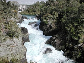
The Aratiatia Rapids are an area of New Zealand river rapids downstream from the dam for the Aratiatia Power Station on the Waikato River. The rapids are extremely dangerous.
Rangatira Park is a suburb in the New Zealand town of Taupō.
Maungaongaonga is an 825 metres (2,707 ft) high dacite volcano located between Rotorua and Taupō in the North Island Volcanic Plateau. The area of the mountain is a scenic reserve and some of its southern slopes are highly geothermally active.


