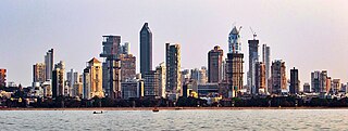
Mumbai is the capital city of the Indian state of Maharashtra. Mumbai is the de facto financial centre and the most populous city of India with an estimated city proper population of 12.5 million (1.25 crore). Mumbai is the centre of the Mumbai Metropolitan Region, the sixth most populous metropolitan area in the world with a population of over 23 million living under the Brihanmumbai Municipal Corporation. Mumbai lies on the Konkan coast on the west coast of India and has a deep natural harbour. In 2008, Mumbai was named an alpha world city.
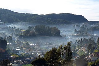
Ooty, officially known as Udhagamandalam, is a town and a municipality in the Nilgiris district of the South Indian state of Tamil Nadu. It is located 86 km (53 mi) north west of Coimbatore, 100 km north west of Tirupur, 128 km (80 mi) south of Mysore and is the headquarters of the Nilgiris district. It is a popular hill station located in the Nilgiri Hills. It is popularly called the "Queen of Hill Stations". It was the summer capital of the Madras Presidency.

Imphal is the capital city of the Indian state of Manipur. It is the second largest city in Northeast India. The metropolitan centre of the city contains the ruins of Kangla Palace, the royal seat of the former Kingdom of Manipur, surrounded by a moat. Spread over parts of the districts of Imphal West and Imphal East, the former contains the majority of the city's area and population. Imphal is part of the Smart Cities Mission under the Ministry of Housing and Urban Affairs.

The Mahanadi River is a major river in East Central India. It drains an area of around 132,100 square kilometres (51,000 sq mi) and has a total length of 900 kilometres (560 mi). Mahanadi is also known for the Hirakud Dam which was the first major multipurpose river valley project after India's independence in 1947. The river flows through the states of Chhattisgarh and Odisha and before finally ending in the Bay of Bengal.

Cuttack in Odia, is the former capital and the second largest city in the Indian state of Odisha. It is the headquarters of the Cuttack district. The name of the city is an anglicised form of the Odia and Sanskrit name Kataka which literally means The Fort, a reference to the ancient Barabati Fort around which the city initially developed. Cuttack is known as the Millennium City as well as the Silver City due to its history of 1000 years and famous silver filigree works. The Orissa High Court is located there. It is the commercial capital of Odisha which hosts many trading and business houses in and around the city. Cuttack is famous for its Durga Puja which is one of the most important festivals of Odisha. Cuttack is also the birthplace of Indian nationalist & freedom fighter Netaji Subhas Chandra Bose from Bengal. The city is categorised as a Tier-II city as per the ranking system used by Government of India.

The Brahmani is a major seasonal river in the Odisha state of eastern India. The Brahmani is formed by the confluence of the Sankh and South Koel rivers, and flows through the districts of Sundargarh, Deogarh, Angul, Dhenkanal, Cuttack, Jajapur and Kendrapara. Also South Koel can be considered as upper reaches of Brahmani. Together with the river Baitarani, Brahmani forms a large delta before emptying into the Bay of Bengal at Dhamra. It is the second widest river in Odisha after Mahanadi.
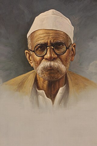
Pandurang Mahadev Bapat, popularly known as Senapati Bapat, was a figure in the Indian independence movement. He acquired the title of Senapati, meaning commander, as a consequence of his leadership during the Mulshi satyagraha. In 1977, the Indian government issued a postage stamp to commemorate him.
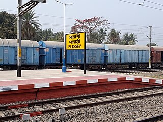
Palashi or Plassey is a town on the east bank of Bhagirathi River, located approximately 50 kilometres north of the city of Krishnanagar in Kaliganj CD Block in the Nadia District of West Bengal, India. The nearest major town is Beldanga. It has its own two local gram panchayat.

Senapati, is one of the 16 districts of the Indian state of Manipur. The present Senapati district was formed in December 2016, after spawning off the Sadar Hills region in the south into a separate Kangpokpi district. The district headquarter is located in the municipality of Tahamzam.

Boudh District is an administrative and a municipal district, one of the thirty in the Odisha, India. The district headquarters of the Boudh District is the city of Boudh.
Sambalpur is the fifth largest city in the Indian State of Odisha. It is located on the banks of river Mahanadi, with a population of 335,761. Prehistoric settlements have been recorded there. It is the home of the Sambalpuri sari.

Hirakud Dam is built across the Mahanadi River, about 15 kilometres (9 mi) from Sambalpur in the state of Odisha in India. It is the longest earthen dam in the world. Behind the dam extends a lake, Hirakud Reservoir, 55 km (34 mi) long. It is one of the first major multipurpose river valley projects started after India's independence. Hirakud Reservoir was declared a Ramsar site on 12 October 2021.

Ashis Nandy is an Indian political psychologist, social theorist, and critic. A trained clinical psychologist, Nandy has provided theoretical critiques of European colonialism, development, modernity, secularism, Hindutva, science, technology, nuclearism, cosmopolitanism, and utopia. He has also offered alternative conceptions relating to cosmopolitanism and critical traditionalism. In addition to the above, Nandy has offered an original historical profile of India's commercial cinema as well as critiques of state and violence.

The history of Odisha begins in the Lower Paleolithic era, as Acheulian tools dating to the period have been discovered in various places in the region. The early history of Odisha can be traced back to writings found in ancient texts like the Mahabharata, Maha Govinda Sutta and some Puranas. The region was also known to other kingdoms in region of East Indies due to maritime trade relations.

Odisha is one of the 28 states in the Republic of India. Odisha is located in the eastern part of the Indian peninsula and the Bay of Bengal lies to its East while Chhattisgarh shares its border in the west and north-west. The state also shares geographic boundaries with West Bengal in the north-east, Jharkhand in the north and Andhra Pradesh in the south. The state is spread over an area of 1,55,707 km2 and extends for 700 km from north to south and 500 kilometres from east to west. Its coastline is 450 km long. The state is divided into 30 districts which are further subdivided into 314 blocks.
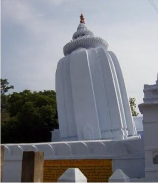
The Leaning Temple of Huma in India is one of only a very few leaning temples in the world. It is located in Huma, a village situated on the bank of the Mahanadi, 23 km south of Sambalpur in the Indian state of Odisha. The temple is dedicated to the Hindu god Lord Bimaleshwar.

The Kharagpur–Puri Line is a railway line connecting Kharagpur in the Indian state of West Bengal and Puri in Odisha. The total line can be divided into sections. The Kharagpur–Khurda Road portion of this line, which is a part of the Howrah–Chennai main line and Khurda Road - Puri portion.

The Chhattisgarh Vidhan Sabha or the Chhattisgarh Legislative Assembly is the unicameral state legislature of Chhattisgarh state in India.
The Anglo-Manipur War was an armed conflict between the British Empire and the Kingdom of Manipur. The war lasted between 31 March and 27 April 1891 and ended in a British victory.


