Humboldt Bay Harbor Recreation & Conservation District
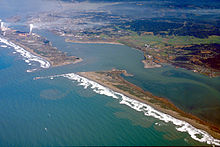
Last updated Aerial view of Humboldt Bay, the Port facilities (primarily in the upper left of photo) and the City of Eureka, California
The Humboldt Bay Harbor Recreation & Conservation District (HBHRCD), created in 1972 by local voters, is the governing body of the Port of Humboldt Bay, a deep water port, and the Port of Eureka. Facilities include those in Eureka (Port of Eureka), the principal city of the region, and much larger facilities in the smaller unincorporated communities Samoa, Fairhaven, and Fields Landing (all in Greater Eureka) on the shore of the adjacent peninsula, known as Samoa. The District is responsible for the immediate environs of Humboldt Bay, California, United States (including marsh lands, estuaries, etc.) and all improvements and facilities located at Shelter Cove, a small oceanside facility and dock in southern Humboldt County. Due to conditions at the Bar (entrance to Humboldt Bay), only pilots trained and employed by the District are used to bring vessels beyond a certain size into or out of the harbor unless the ship's pilot has proper certification.
Humboldt Bay, California's second largest enclosed natural bay, located on the Northern California coast, approximately 225 miles (362km) north of San Francisco and 156 nautical miles (289km) south of Coos Bay, Oregon, is 14 miles long and contains the only large deep water port for the entirety of Northern California north of San Francisco Bay.
San Francisco Bay is a large tidal estuary in the U.S. state of California, and gives its name to the San Francisco Bay Area. It is dominated by the cities of San Francisco, San Jose, and Oakland.
Humboldt County is a county located in the U.S. state of California. As of the 2020 census, the population was 136,463. The county seat is Eureka.
Arcata is a city adjacent to the Arcata Bay (northern) portion of Humboldt Bay in Humboldt County, California, United States. At the 2020 census, Arcata's population was 18,857. Arcata was first founded in 1850 as Union, was officially established in 1858, and was renamed Arcata in 1860. It is located 280 miles (450 km) north of San Francisco, and is home to California State Polytechnic University, Humboldt. Arcata is also the location of the Arcata Field Office of the Federal Bureau of Land Management, which is responsible for the administration of natural resources, lands and mineral programs, including the Headwaters Forest, on approximately 200,000 acres (810 km2) of public land in Northwestern California.
Eureka is a city and the county seat of Humboldt County, located on the North Coast of California. The city is located on U.S. Route 101 on the shores of Humboldt Bay, 270 miles (435 km) north of San Francisco and 100 miles (161 km) south of the Oregon border. At the 2020 census, the population of the city was 26,512 and the population of the greater Eureka area was 48,119.
Ferndale is a city in Humboldt County, California, United States. Its population was 1,481, up from 1,371 at the 2010 census. The city contains dozens of well-preserved Victorian storefronts and homes. Ferndale is the northern gateway to California's Lost Coast and the city, which is sited on the edge of a wide plain near the mouth of the Eel River, is also located near extensive preserves of coast redwood forests.
The Eel River is a major river, about 196 miles (315 km) long, in northwestern California. The river and its tributaries form the third-largest watershed entirely in California, draining a rugged area of 3,684 square miles (9,540 km2) in five counties. The river flows generally northward through the Coast Ranges west of the Sacramento Valley, emptying into the Pacific Ocean about 10 miles (16 km) downstream from Fortuna and just south of Humboldt Bay. The river provides groundwater recharge, recreation, and industrial, agricultural and municipal water supply.
San Diego Bay is a natural harbor and deepwater port in San Diego County, California, near the Mexico–United States border. The bay, which is 12 miles (19 km) long and 1 to 3 miles wide, is the third largest of the three large, protected natural bays on California's 840 miles (1,350 km) of coastline, after San Francisco Bay and Humboldt Bay. The highly urbanized land adjacent to the bay includes the city of San Diego and four other cities: National City, Chula Vista, Imperial Beach and Coronado. The bay is considered to be one of the premier natural harbors on the West Coast.
San Pedro Bay is an inlet on the Pacific Ocean coast of southern California, United States. It is the site of the Port of Los Angeles and the Port of Long Beach, which together form the fifth-busiest port facility in the world and the busiest in the Americas. The Los Angeles community of San Pedro borders a small portion of the western side of the bay. The city of Long Beach borders the port on the eastern side of the bay. The northern part of the bay, which is the largest part of the port, is bordered by the Los Angeles neighborhood of Wilmington.
Humboldt Bay is a natural bay and a multi-basin, bar-built coastal lagoon located on the rugged North Coast of California, entirely within Humboldt County, United States. It is the largest protected body of water on the West Coast between San Francisco Bay and Puget Sound, the second-largest enclosed bay in California, and the largest port between San Francisco and Coos Bay, Oregon. The largest city adjoining the bay is Eureka, the regional center and county seat of Humboldt County, followed by the city of Arcata. These primary cities, together with adjoining unincorporated communities and several small towns, comprise a Humboldt Bay Area with a total population of nearly 80,000 people. This comprises nearly 60% of the population of Humboldt County. The bay is home to more than 100 plant species, 300 invertebrate species, 100 fish species, and 200 bird species. In addition, the bay and its complex system of marshes and grasses support hundreds of thousands of migrating and local shore birds. Commercially, this second-largest estuary in California is the site of the largest oyster production operations on the West Coast, producing more than half of all oysters farmed in California.
Bayside is an unincorporated community 2.25 miles (3.6 km) south-southeast of Arcata, at an elevation of 33 feet in Humboldt County, California. The ZIP Code is 95524, the area code is 707. The relatively large area was originally covered by large, ancient Coast Redwood trees down to what was the edge of a significantly larger Humboldt Bay at high tide. Later, the mammoth redwoods made it the natural placement of some of the area's earliest redwood lumber operations. A rock quarry was located in the area's hills, which form the beginning of the Coast Ranges, the source of water for an early public water system for the City of Arcata. Today, Bayside provides Arcata a buffer from Eureka's northward expansion along US Route 101 and the area, with the exception of some business and public buildings, is largely rural, with homes and small ranches dotting the landscape. Second growth forests exist mostly apart from cleared lands, which show some evidence of the extensive redwood forest that once existed in the form of large stumps. Some of the area's older Victorian era houses, are still present on the Old Arcata Road, the original main road connecting Arcata to Eureka. Jacoby Creek runs alongside a road of the same name from the hills in the direction of the Bay.
The North Coast of California is a region in Northern California that lies on the Pacific coast between San Francisco Bay and the Oregon border. It commonly includes Mendocino, Humboldt, and Del Norte counties and sometimes includes Lake and two counties from the San Francisco Bay Area, Marin and Sonoma.
Fieldbrook is a census-designated place in Humboldt County, California. It is located 7 miles (11 km) north-east of Arcata, at an elevation of 203 feet (62 m). The population was 860 following the 2010 census.
Samoa is a census-designated place in Humboldt County, California. It is located 1.5 miles (2.4 km) northwest of Eureka, at an elevation of 23 feet (7 m). Samoa is located in the northern peninsula of Humboldt Bay and is the site of the Samoa Cookhouse, one of the last remaining original lumber camp–style cookhouses. The name Samoa is used interchangeably to refer to the peninsula it occupies. The population was 258 at the 2010 census.
Coast Guard Sector/Air Station Humboldt Bay is a United States Coast Guard Air Station and Sector, with command and primary assets located at the Arcata-Eureka Airport in McKinleyville, California, 16 miles north of Eureka in Humboldt County. The station is the site of the command center for all Coast Guard personnel stationed and assets located on the coasts of Humboldt, Mendocino, and Del Norte Counties. It is one of four air stations in the Eleventh Coast Guard District.
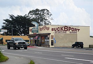
Bucksport was a town in Humboldt County, California. The original location was 2.5 miles (4 km) southwest of downtown Eureka, on Humboldt Bay about 5 miles (8 km) northeast of entrance. at an elevation of 16 feet (4.9 m). Prior to American settlement a Wiyot village named Kucuwalik stood here.
Freshwater is an unincorporated community in Humboldt County, California. It is located on Freshwater Creek, a major tributary to Humboldt Bay, 7.5 miles (12 km) south of Arcata, at an elevation of 92 feet. The area is the site of a now logged massive old-growth redwood forest and prevalent remaining second-growth forest. The trees in the area are storied to have been some of the largest coast redwoods to have ever existed. On September 24, 1964, the large area and all its residents became part of unincorporated Eureka, within the 95503 zipcode. Freshwater Park, a Humboldt County Park, which has picnic areas and a swimming area each summer, is located nearby on Freshwater Creek.
The Humboldt Bay Life-Saving Station was originally built in November 1878 on the north side of the entrance to Humboldt Bay in northern California, United States, near Eureka, adjacent to the site of the first Humboldt Harbor Light (1856–1892). Rebuilt in 1936 with marine railways to launch rescue surfboats, the historic facility was placed on the National Register of Historic Places on October 30, 1979. The station continues to function as an important asset of the United States Coast Guard in the Coast Guard Group/Air Station Humboldt Bay.
The Salt River is a formerly navigable hanging channel of the Eel River which flowed about 9 miles (14 km) from near Fortuna and Waddington, California, to the estuary at the Pacific Ocean, until siltation from logging and agricultural practices essentially closed the channel. It was historically an important navigation route until the early 20th century. It now intercepts and drains tributaries from the Wildcat Hills along the south side of the Eel River floodplain. Efforts to restore the river began in 1987, permits and construction began in 2012, and water first flowed in the restored channel in October 2013.
The Elk River is a river in the U.S. state of California, originating at 2,000 feet (610 m) elevation in forested highlands southeast of Eureka, California. The north and south forks combine to flow 15 miles (24 km) into Humboldt Bay on the south edge of Eureka. The river was called Ka-sha-reh by the Wiyot people, but received its present name after Josiah Gregg's party enjoyed a meal of elk meat near the river on Christmas, 1849.
Freshwater Creek is a 23 kilometres (14 mi) long creek in Humboldt County, California that is a tributary of the Eureka Slough that in turn feeds Humboldt Bay. It flows into the south-east corner of the Arcata Bay sub-bay of Humboldt Bay. Its downstream reach is also known as Freshwater Slough and its upstream reach as Freshwater Gulch.
This page is based on this Wikipedia article Text is available under the CC BY-SA 4.0 license; additional terms may apply. Images, videos and audio are available under their respective licenses.