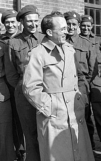
Royal University Hospital, often abbreviated RUH, is one of three hospitals in Saskatoon, Saskatchewan. It is located on the University of Saskatchewan campus. RUH is a teaching hospital and closely tied to the College of Medicine within the university. It was opened on May 14, 1955 by Saskatchewan premier Tommy C. Douglas.

Highway 5 is a major highway in the Canadian province of Saskatchewan. It begins in downtown Saskatoon and runs eastward to the Manitoba border near Togo, where it becomes Provincial Road 363. The highway is approximately 393 kilometres (244 mi) long. Between the early 1900s (decade) and 1976, Provincial Highway 5 was a trans-provincial highway travelling approximately 630 kilometres (390 mi) in length. At this time it started at the Alberta border in Lloydminster and traveled east to the Manitoba border.

Nutana is a primarily residential neighbourhood located near the centre of Saskatoon, Saskatchewan, Canada. It includes the business district of Broadway Avenue. It comprises a nearly even mixture of low-density, single detached dwellings and apartment-style multiple unit dwellings. As of 2009, the area is home to 6,261 residents. The neighbourhood is considered a middle to upper-income area, with an average family income of $67,657, an average dwelling value of $206,830 and a home ownership rate of 51.3%. According to MLS data, the average sale price of a home as of 2013 was $409,891. First established in 1883, Nutana was the original settlement of what now makes up the city of Saskatoon.
Saskatoon is the most populous city in the Canadian province of Saskatchewan. Canada is a constitutional monarchy, and connections to the Crown in Saskatoon are visible in visits from the Sovereign, the Royal Family and vice-regal representatives, and also in the prominence of names and symbols in civic traditions. The Crown's image appears in the centrepiece portrait at Saskatoon City Council chamber and also in the badges of Saskatoon Police Service officers. On one of several visits to Saskatoon, the Queen said "Constitutional Monarchy has always placed the emphasis on people in community – as it were, a national family with the Sovereign as its head." Saskatoon's manifold connections include more than a dozen royal visits, frequent vice-regal visitors, namesakes for schools, streets and neighbourhoods, and the regular inclusion of its own namesake, the saskatoon berry, on menus for royal and vice-regal functions. Canada's definitive postage stamp features a photograph of the Queen taken in Saskatoon.

The Central Business District is one of seven development districts in Saskatoon, Saskatchewan, Canada. The central business district is Ward 6 of a Mayor-Council government represented by councillor Cynthia Block. Formerly called West Saskatoon, this area arose when the steam engines built their pumping stations on the lower west bank of the South Saskatchewan River. Retail enterprises sprang up around the newly created train station and rail yards. The city of Saskatoon's Central Business District has shopping malls and boutiques.

Pleasant Hill is a neighbourhood of Saskatoon, Saskatchewan, Canada. The Governments are undertaking a major re-vitalization project of Pleasant Hill. $3.5 million is being invested in the business, and residential areas as well as in St. Mary's School. Together the Saskatoon Urban Renewal Project, the provincial government and the Western Economic Diversification project of the federal Government will result in neighbourhood overhauls. 29 lots zoned for business along 20th Street will be levelled and modern commercial upgrades put into place. Selected lots along Avenue N and Avenue O zoned as residential will be demolished to make way for affordable and decent homes. St. Mary's School will receive major renovations or replacement, possibly even a new community centre.

City Park is a mixed-use neighbourhood located near the center of Saskatoon, Saskatchewan, Canada. It comprises a mix of single-family detached homes, apartment buildings and other semi-detached dwellings. It also contains a number of commercial zones with businesses. As of 2009, the area was home to 4,405 residents. The neighbourhood is considered a middle-income area, with an average family income of $42,236, an average dwelling value of $245,254 and a home ownership rate of 28.6%.

The Exhibition subdivision of Saskatoon, Saskatchewan, Canada, is located on the banks of the South Saskatchewan River and was developed between the two major World Wars. To the west is the Diefenbaker Management Area which boasts the Diefenbaker park and Pioneer Cemetery. The park includes a medium-sized hill which is used for tobogganing and snowboarding, and the park itself is a frequently-used venue for picnics and public events and performances. The Exhibition community is also known as Thornton, after a (now-decommissioned) elementary school that formerly served the area and early in its history also went by the name Bellevue.

Bethlehem Catholic High School is a separate (Catholic) high school in Saskatoon, Saskatchewan, Canada, that opened in August 2007. It is located off 22nd Street West in the Blairmore Suburban Centre neighbourhood.

Parkridge is a residential community in western Saskatoon, Saskatchewan, located on land annexed by the city between 1975 and 1979. Development of the subdivision (initially called "Fairhaven II" after the neighbouring community to the east, began in the early 1980s. The extreme west end of the neighbourhood remained undeveloped until the subsequent creation of the adjacent Blairmore Suburban Centre led to the final phase of Parkridge being built out in the early 2010s. Whereas the majority of residents are employed in the sales and service sector, the next highest employer is business, finance and administration. The two main age groups are those in their 40s and teenagers as of 2005. Until recently Parkridge was the farthest western neighbourhood of Saskatoon south of 22nd Street. However, new construction will soon see Neighbourhood 2 of the Blairmore SDA bear that claim to fame. In comparison, the neighbourhood of Parkridge with a 2001 census population of 4,505 is larger than the Saskatchewan city of Melville which had a population of 4,149 in 2006, and 4,453 in 2001 and Parkridge is a little smaller than the provincial city of Humboldt which was 4,998 in 2006, and 5,161 in 2001. In Saskatchewan rural towns must maintain a population above 5,000 to apply for city status. According to MLS data, the average sale price of a home as of 2013 was $327,072.

University of Saskatchewan has over 200 academic programs on its Saskatoon, Saskatchewan campus, and is internationally known for its teaching and research. The on-campus synchrotron Canadian Light Source makes it the only Canadian institution for such nuclear and biotechnology research. Canadian Light Source nuclear research facility provides research and analysis of the internal structures of advanced materials and biological samples. The College of Arts and Science is the largest of the U of S and comprises five separate health science fields in addition to numerous other programs in the Arts, Social Sciences, Humanities, and Natural Sciences. The Department of Computer Science as well as the College of Engineering are ranked highly within their fields. The founding college, the College of Agriculture, is still providing agricultural breakthroughs which are utilized worldwide.
Bruno is a town located 90 km east of Saskatoon and 35 km west of Humboldt. Its current mayor is Dale Glessman.
River Heights is a neighbourhood in Lawson Suburban Development Area, Saskatoon, Saskatchewan. Its eastern boundary borders the South Saskatchewan River. The suburb is just south of the Mall at Lawson Heights. Development of the neighbourhood began in the very early 1960s, with full build out completed by the early 1980s. Most of the neighbourhood's land was annexed by the city in the late 1950s, with the eastern third of the district annexed in 1974.

U of S Lands South Management Area is an area of and located in east-central Saskatoon, Saskatchewan, Canada. It is a categorized as a management area, as it lacks the residential, industrial or future development characteristics present in most neighbourhoods. The area is home to 1,103 residents living in residences belonging to the University of Saskatchewan. The neighbourhood is considered a lower-income area, with an average family income of $36,760, an average dwelling value of $221,222 and a home ownership rate of 0.2%, though this is, of course, due to residents being primarily students renting accommodation from the university.
St. Paul's Hospital is a public hospital at 20th Street and Avenue P in the Pleasant Hill neighborhood of Saskatoon, Saskatchewan. St. Paul's works with the Saskatchewan Health Authority in an interdependent partnership. The hospital is owned by the Saskatchewan Catholic Health Corporation and was founded by the Grey Nuns.

The University of Colorado Anschutz Medical Campus is the campus that houses the University of Colorado's health sciences-related schools and colleges, including the University of Colorado School of Medicine, the CU School of Pharmacy, the CU College of Nursing, the University of Colorado School of Dentistry, and the Colorado School of Public Health, as well as the graduate school for various fields in the biological and biomedical sciences.
Jawahar (Jay) Kalra MD, PhD, FRCPC, FCAHS, CCPE is a Canadian physician, award-winning clinical researcher, educator, academic leader, and community builder. Dr. Kalra is a professor at the Department of Pathology and Laboratory Medicine at the University of Saskatchewan, a Fellow of the Royal College of Physicians and Surgeons of Canada, the Canadian Academy of Clinical Biochemistry, the Canadian Academy of Health Sciences, an Elected Fellow of the Royal Society of Medicine, UK and a Canadian Certified Physician Executive Leader (CCPE). Dr. Kalra also serves as a member, Board of Governors, University of Saskatchewan and Board of Directors, Council of Canadian Academies (CCA).