Related Research Articles

A chambered cairn is a burial monument, usually constructed during the Neolithic, consisting of a sizeable chamber around and over which a cairn of stones was constructed. Some chambered cairns are also passage-graves. They are found throughout Britain and Ireland, with the largest number in Scotland.

Caithness is a historic county, registration county and lieutenancy area of Scotland.

Sanday is one of the inhabited islands of Orkney that lies off the north coast of mainland Scotland. With an area of 50.43 km2 (19.5 sq mi), it is the third largest of the Orkney Islands. The main centres of population are Lady Village and Kettletoft. Sanday can be reached by Orkney Ferries or by plane from Kirkwall on the Orkney Mainland. On Sanday, an on-demand public minibus service allows connecting to the ferry.

Eday is one of the islands of Orkney, which are located to the north of the Scottish mainland. One of the North Isles, Eday is about 24 kilometres from the Orkney Mainland. With an area of 27 km2 (10 sq mi), it is the ninth-largest island of the archipelago. The bedrock of the island is Old Red Sandstone, which is exposed along the sea-cliffs.
Westray is one of the Orkney Islands in Scotland, with a usual resident population of just under 600 people. Its main village is Pierowall, with a heritage centre, the 15th-century Lady Kirk church and pedestrian ferry service to nearby Papa Westray island. Westray has a number of archeological sites dating from 3500 BC, and remains of several Norse-Viking settlements. The spectacular sea cliffs around Noup Head are home to thousands of seabirds.

The Knap of Howar on the island of Papa Westray in Orkney, Scotland is a Neolithic farmstead which may be the oldest preserved stone house in northern Europe. Radiocarbon dating shows that it was occupied from 3700 BC to 2800 BC, earlier than the similar houses in the settlement at Skara Brae on the Orkney Mainland.

Rendall is a parish on Mainland, Orkney, Scotland. It is in the north west of the island and lies east of the parishes of Birsay and Evie and north east of Harray. The island of Gairsay is also in the parish.

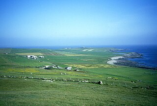
Huna is a small remote crofting township, located 1 mile northeast of Canisbay and 1.5 miles west of John o' Groats in Caithness, in Scotland. It is currently part of the Highland Council area.

Prehistoric Orkney refers only to the prehistory of the Orkney archipelago of Scotland that begins with human occupation. Although some records referring to Orkney survive that were written during the Roman invasions of Scotland, “prehistory” in northern Scotland is defined as lasting until the start of Scotland's Early Historic Period.

Unstan is a Neolithic chambered cairn located about 2 mi (3 km) north-east of Stromness on Mainland, Orkney, Scotland. The tomb was built on a promontory that extends into the Loch of Stenness near the settlement of Howe. Unstan is notable as an atypical hybrid of the two main types of chambered cairn found in Orkney, and as the location of the first discovery of a type of pottery that now bears the name of the tomb. The site is in the care of Historic Environment Scotland as a scheduled monument.

Midhowe Broch is an iron-age broch located on the west coast of the island of Rousay in the Orkney Islands, in Scotland.

The Port an Eilean Mhòir boat burial is a Viking boat burial site in Ardnamurchan, Scotland, the most westerly point on the island of Great Britain. Dated to the 10th century, the burial consists of a Viking boat about 5 metres long by 1.5 metres (5 ft) wide in which a man was laid to rest with his shield, sword and spear as well as other grave goods.

Scandinavian Scotland refers to the period from the 8th to the 15th centuries during which Vikings and Norse settlers, mainly Norwegians and to a lesser extent other Scandinavians, and their descendants colonised parts of what is now the periphery of modern Scotland. Viking influence in the area commenced in the late 8th century, and hostility between the Scandinavian earls of Orkney and the emerging thalassocracy of the Kingdom of the Isles, the rulers of Ireland, Dál Riata and Alba, and intervention by the crown of Norway were recurring themes.

The Scar boat burial is a Viking boat burial near the village of Scar, on Sanday, in Orkney, Scotland. The burial, which dates to between 875 and 950 AD, contained the remains of a man, an elderly woman, and a child, along with numerous grave goods. Although the site had to be excavated quickly because of the threat of coastal erosion owing to bad weather conditions, it yielded many important finds.
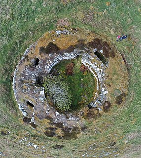
Ousdale Broch, also known as Ousdale Burn or Allt a’ Bhurg Broch, is an Iron Age broch located between the villages of Helmsdale and Berriedale in Caithness, Scotland.

Skaill House is a historic manor house in Sandwick parish on Mainland, the largest of the Orkney Islands, Scotland. The house overlooks the neolithic site, Skara Brae, and the Bay of Skaill.

The remains of the Orphir Round Church, dedicated to Saint Nicholas, are located in Orphir Parish on the Mainland of Orkney, Scotland. It has been a scheduled monument since 2014.
Telford Parliamentary church also known as the Telford Kirks are a series of presbyterian churches in Scotland built with money voted from the parliament of the United Kingdom as a result of the Church of Scotland Act 1824 for a grant of £50,000, designed by the surveyor William Thomson and built by the Scottish stonemason and architect Thomas Telford. In total, 32 churches were built and many are still in use today. Others have been abandoned, e.g. at Stoer, while others were destroyed and rebuilt, e.g. at Tobermory, while others have been converted to dwellings.

The Orkney Museum, formerly Tankerness House Museum, is a history museum in Kirkwall, Orkney, Scotland. Run by Orkney Islands Council, the museum covers the history of the Orkney Islands from the Stone Age through the Picts and Vikings to the present day.

Tofts Ness is a peninsula located on the north-east tip of the island of Sanday in Orkney, Scotland. It encompasses a prehistoric site which shows evidence of human occupation beginning in the late Neolithic Age and continuing through the Iron Age. The scheduled monument consists of mounds, cairns, enclosures, ancient soils and structural remains. Tofts Ness is also the location of multiple shipwrecks.
References
- ↑ "Huna House Hotel". Historic Environment Scotland. 2 January 2017.
- ↑ "Huna House Hotel". Canmore. 2 January 2017.
- ↑ "Resource list". Government of Scotland. p. 9. Retrieved 2 January 2017.
- ↑ Mountford John Byrde Baddeley (1901). Scotland: Northern Highlands. Dulau. p. 141.
- ↑ The Scots Law Times. C.E. Green. 1895. pp. 406–407.
- ↑ "Slater's Royal National Commercial Directory of Scotland". Manchester. 1903. Retrieved 2 January 2017– via National Library of Scotland.
- ↑ "Day 42 – Duncansby Head to Gill's Bay". Walking Scotlands Coast. Retrieved 2 January 2017.
- ↑ "Huna - Midden (Viking), Settlement (Viking) (Possible)". Canmore. Retrieved 2 January 2017.
- ↑ "Orkney Research Centre for Archaeology: Data Structure Report for a Watching Brief at Huna, Caithness, NGR ND 3592 7341" (PDF). Highland Historic Environment Record. pp. 7, 13. Retrieved 2 January 2017.
- ↑ Batey, C E. (1984), "Caithness coastal survey 1980-82: Dunnet Head to Ousdale", Occasional Paper No. 3. Durham. RCAHMS Shelf Number: E.2.1.BAT, Durham University Department of Archaeology
- ↑ "Huna Hotel - Ship Burial (Viking)". Canmore. Retrieved 2 January 2017.
- ↑ "Huna - Mound". Canmore. Retrieved 2 January 2017.